The Vava'u Island group in the Kingdom of Tonga is a group of more than 50 islands approximately 150 miles north of Tongatapu. All of the islands are either raised coral limestone or coral atolls. The beautiful anchorage opposite the main town of Neiafu (known as the Port of Refuge Harbour) is a common destination for South Pacific cruisers.
This island group has a year-round climate suitable for swimming, snorkelling, diving and sailing. Some islands are ringed by white sand beaches, while others have tropical forests, sea-level caves and dramatic limestone cliffs.
There are over 40 anchorages in the Vava’u group, all within 10 nms of each other. Neiafu, the main town welcomes cruisers with its mix of shoreside establishments and marine services. It is located on the southern coast of Utu Vava'u, the principal island of the Vava'u archipelago.
Vava'a is one of the areas in Tonga which is now subject to Special Management Areas (SMAs) and Fish Habitat Reserves (FHRs).
See the Tonga Restrictions section for full details
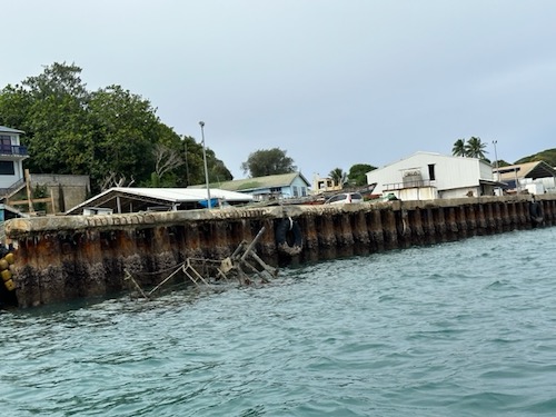
The Customs dock at Neiafu is tricky for docking, yet, coming alongside is necessary for international clearance. It is a lee shore and there are two sunken wrecks to keep clear of. Make sure you avoid the end of the dock nearest to the channel as there is a fishing boat that has sunk right next to the quay and is only visible at low tide. There is also another wreck at the other end of the dock. Only one is marked with a red buoy. It is recommended to inspect the dock first from the shore, before coming alongside.
Be aware that Vava'u has 3 FADs (Fish Aggregating Devices) on the reef south of Pangi.
Tonga Geological Services maintains a Hazard Alert warning for all marines to keep at least two nautical miles (4kms) away from the Home Reef Volcano due to ongoing volcanic activity. The Hazard Alert was updated in January 2026 after increased seismic activity around the volcano. Vava'u and Ha'apai are not considered at risk.
Home Reef is located 25 km southwest of Late Island, 22 km northeast of Lateiki (Metis Shoal), and 75 km northwest of Mo’unga’one Island at Latitude & Longitude 18.992°S & 174.775°W.
Greg Just
Email: greg@vavau.to
Phone +676 71322 (Tropicana Cafe)
Mobile: +676 881 2347 or +676 7512347
VHF Channel 26
Greg is port officer for all the well known cruising associations and produces this local info. pdf for visiting yachts (continually updated) which has a plethora of useful information.
18°40.4'S, 174° 01.95'W (Entrance channel)
18°39.47'S, 173° 58.98'W (Anchorage)
Last updated: February 2026

Leave a comment
You must Login or Register to submit comments.
Comms in Tonga update post-earthquakes:
Two earthquakes during August (6.9 and a 6.6) have caused no serious damage on land, although unfortunately have affected the undersea fibre cable which had just been repaired. The Boatyard Vava’u report “It has affected the local network providers, however Digicel have switched over to their backup systems so the phones are working and internet is ok, not 100% though. We still have several restaurants in town that have Starlink and offer use of their internet as well.”
Cruisers should be aware. On September 10th, 2019, the co-owner of the hideaway bar in neiafu physically attacked a customer at their establishment. During a conversation, she choked and tackled my wife. My wife now has bruises all over and is suffering neck and back pain from being tackled to the deck. We have reported the incident to the police, but thought the cruising community should know.
This was not a Tongan, but an expat who owns a business. This should not be a reflection of neiafu or the people here. The community is wonderful and this is an incident not at all to do with the people of neiafu
Brief updates from Royce Reid:
Wanted to briefly update a couple of things regarding Tonga.
The check-in in Vava’u was fast and simple. They told us how to extend our boat permit from 4 months to 12. the Customs guy also said there is a proposal under consideration to extend the cruising permit from 12 months to at least 18 months.
The immigration people were friendly and fast and told us where to go to extend our 30-day entry visas. We hauled out in Vava’u at the boatyard there and it was fast efficient and friendly.
We also got a quote for the bottom job and it was almost half price VS. New Zealand. they have also opened a chandlery there. If they don’t have it on hand they can order it tax-free from NZ and it arrives fast with fed ex ( within 7 days we were told ) or cheap by boat.
But takes three weeks. We replaced flares and brought interior paint and some nuts and bolts. Not a huge shop but it has the necessities and arranges for specifics! All in all, it was an awesome easy experience and that’s not even commenting on how amazing the cruising there is!
Royce Reid.
I had arrived Saturday (the 3rd of Nov.) at 1530 local time and managed to get cleared. I was told by the Customs agent that they stay on a stand-by basis every Saturday till 1600.
I managed to call when we were 30 miles away raising awareness of our arrival, and also contacted Vava’u Radio on VHF Ch 26 twice before arriving.
Posted on behalf of Clare Sudlow:
Vava’u Bluewater Festival
Calling all South Pacific Cruisers! – Don’t miss the 2016 Vava’u Blue Water Festival! A fun-filled week in Vava’u, Tonga from October 1st- 8th.
Enjoy the friendliest of welcomes & a week of local festivities, parades, informative talks & parties centered around a mid-week fun cruisers race day.
For full info visit: http://www.vavau.to/bluewaterfestival