
- https://www.facebook.com/YachtAidGlobal
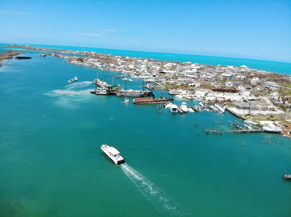
The Bahamas is an archipelago of over 700 islands spread out over 100,000 square miles of ocean and only a small portion of the country was impacted by Hurricane Dorian. The Abaco Islands and Grand Bahama Island were worst affected with aerial images showing a trail of destruction.
The hurricane made landfall on Sunday, 1 September at Elbow Cay as a Category 5 storm moving across the Abacos towards Grand Bahama Island where it paused for two days.
Storm surge is what has had a major destructive effect on the landscape and infrastructure and it is estimated that approx. 60% of Grand Bahama was inundated by flooding due to the storm.
Flooded roads and runways have made first response a big challenge and consequently, USCG helicopters are the only means by which rescues and medical evacuations can be carried out. The death toll has reached 20+ but is expected to be much higher.
Operation Topaz run by Yacht Aid Global successfully landed supplies and thousands of gallons of water yesterday at Marsh Harbour when motor yacht “Loon” arrived loaded to capacity.
Locations that are in need of re-supply or evacuation assistance are Green Turtle Cay, Elbow Cay, Turtle Cay and around Marsh Harbor.
The SCCA advise: Small private vessels are discouraged at this time from going into the disaster areas– from a logistical and a safety standpoint. People are desperate, and may not act in civilized manners while in that state; there is violence and in the aftermath of this disaster, the sewage and debris do raise health issues at this stage.
The United States Coast Guard News alert advises:
“For their safety, the Coast Guard advises mariners to not attempt voyages into the Northern Bahamas until further notice due to the devastating effects of Hurricane Dorian. The Government of the Bahamas is currently assessing its northern ports and harbors to determine if they are safe to enter. There is a high risk of debris in the water, sunken vessels, and destroyed or missing aids to navigation and pier facilities. There is also the risk of chemical spills and changes to the topography/hydrology in ports and marinas from the prolonged winds and storm surge of the Category 5 hurricane.”
The Bahamas Tourist Board has said: “Islands that were not impacted by Hurricane Dorian remain open and are receiving visitors. In the Northwest Bahamas, these include the Bahamas capital of Nassau and neighboring Paradise Island, as well as Eleuthera, Harbour Island and Andros. Islands in the Southeastern and Central Bahamas remain unaffected, including The Exumas, Cat Island, San Salvador, Rum Cay, Long Island, Acklins/Crooked Island, Ragged Island, Mayaguana and Inagua. Lynden Pindling International Airport (LPIA) in Nassau remains open.”
Where is Dorian Now?
Dorian has now moved off north and spent today pounding much of the Carolina coast with heavy rain and strong winds. Although the hurricane has lost strength and is now a category two storm (maximum sustained winds of 105mph (165km/h)), it has grown larger in area. It continues to weaken however as it moves NE up the East coast of the States with predicted strong winds for Nova Scotia and Prince Edward Island on Saturday.
Further Information and Useful Links:
Hopetown on Elbow Cay in the Abaco Islands suffered a direct hit by Dorian. The Hope Town Sailing Club’s website has current photos, donor links, and updates: https://www.hopetownsailingclub.com/
Lists of items needed by those affected by Hurricane Dorian:
https://www.facebook.com/ABMMarinas/
https://www.bahamas.com/relief
Yacht Aid Global: https://www.facebook.com/YachtAidGlobal/
Cruising World has a compilation of news updates and resources which they are continually updating: https://www.cruisingworld.com/hurricane-dorian-abacos-update/
Dorian Disaster: How to help the Bahamas… And how not to (Passagemaker Magazine)
Bahamas Facebook Groups: (from Bahamas Land and Sea)
Hope Town
https://www.facebook.com/hopetownbulletin/
Green Turtle Cay
https://www.facebook.com/groups/929753750421644/?ref=share
Great Guyana Cay
https://m.facebook.com/guanacay/
Walkers & Grand Cay
https://www.facebook.com/groups/114954548526916/?ref=share
Dorian Relief from the Yachting Community
https://www.facebook.com/groups/481196102716515/?ref=share
Abaco Living On Island Time
https://www.facebook.com/groups/52257991478/?ref=share
United States Coast Guard
https://www.facebook.com/USCoastGuardSoutheast/
Government of the Bahamas
https://www.facebook.com/Bahamas-Information-Services-446756285357857/
Related News:
Bahamas: Post-Dorian Recovery Three Weeks On
24 September – Noonsite
Relief for the Bahamas after Hurricane Dorian – How you can help
12 September – OCC
Hurricane Dorian: Scale of Bahamas devastation emerges
5 September – BBC
Hurricane Dorian makes landfall in the Bahamas
4 September – Noonsite
Noonsite has not independently verified this information.