
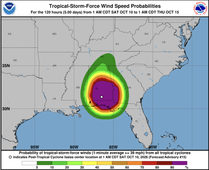
Hurricane Isaias formed in early October 2026 and rapidly intensified into a Category Three major hurricane over the Gulf of Mexico before making landfall along the U.S. Gulf Coast (near the Florida Panhandle/Mississippi region) as a Category Two system.
NOAA’s National Hurricane Center warned of dangerous and damaging hurricane force-winds torrential rainfall, severe storm surges (up to 7 feet) and localized flooding across the Florida Panhandle, southern Alabama and southern Mississippi.
Late-Season First Hurricane
Under normal atmospheric conditions, the timing of Hurricane Isaias is extraordinarily rare. According to NOAA, historical data (1991–2020), the first hurricane of the Atlantic season normally forms in early to mid-August.
A first hurricane reaching status in October ties a record going back to 1905 for the latest date a first hurricane was recorded in the Atlantic basin.
The primary driver behind the quiet Atlantic season in 2026 is a strong El Niño pattern which creates strong atmospheric wind shear (disruptive changes in wind speed and direction with height) across the Atlantic basin, which rips developing tropical disturbances apart before they can organize into hurricanes. Cool air-sea interactions and deeper cooler water layers in parts of the basin further suppressed storm development earlier in the northern hemisphere summer.
When a tropical disturbance entered the Gulf of Mexico in early October, localized atmospheric conditions temporarily relaxed the strong wind shear, allowing the storm to capitalize on warm surface waters in the Gulf and rapidly intensify into a major hurricane.
Meanwhile in the Pacific
The Pacific Ocean continues to experience significant activity due to the atmospheric patterns driven by El Niño. While El Niño suppress hurricane formation in the Atlantic, it creates ideal conditions—such as warmer ocean waters and reduced atmospheric resistance—across the Pacific.
Eastern Pacific
- Hurricane Simon rapidly organized in early October and reached major hurricane status with sustained winds exceeding 120 mph. Authorities are closely monitoring the system as it tracks north/northwest parallel to the Mexican coastline.
- Hurricane Rachel peaked as a major hurricane (Category 3/4) in late September before moving over cooler waters and gradually weakening into a tropical storm. Moisture from its outer circulation has brought increased cloud cover and moisture toward parts of the southwestern United States and Baja California.
Western Pacific
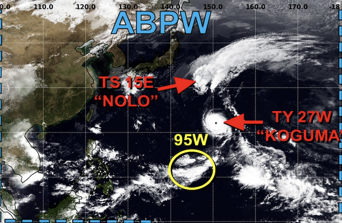
- In the Western Pacific Japan News is reporting that Typhoons Nolo and Koguma may impact the country from this weekend into next week.
- Typhoon Nolo was situated near Minamitori Island in the North Pacific. It is forecast to maintain its west-northwest path until around Friday, before pivoting northwest over the waters in the east of Ogasawara Islands.
- Typhoon Koguma was located near Wake Island and heading north-northwest at 15 kilometers per hour, with its central atmospheric pressure at 990 hectopascals as of 6 a.m. on Thursday.
- The remnants of Typhoon Choi-wan which is now a subtropical depression and was located in the waters east of the Japanese island of Hokkaido.
……………………………
Related News:
- Hurricane Isaias Makes Landfall in Florida (BBC)
- Atlantic Ocean Breaks 60 Year Record (CBS News)
- Typhoons Nola and Koguma Approaching Japan (Japan News)
- Weather, Hurricanes: Quiet in the Atlantic but Active in the Pacific (Noonsite)
………………………………
Related Links:
- National Hurricane Center
- National Oceanic and Atmospheric Administration
- Stormdom – Global Storm Tracker
- Joint Typhoon Warning Center
…………………………………
If you have found this information useful, become a paid member to enjoy unlimited use of Noonsite plus many other perks. Your membership fees really help our small, dedicated team keep country information up-to-date in support of cruisers worldwide. Find out more about Noonsite Membership levels and benefits here.
Subscribe to our FREE monthly newsletter: https://www.noonsite.com/newsletter/
Leave a comment
You must Login or Register to submit comments.