
Super Typhoon Bavi is expected to make landfall on Monday morning July 6, local time with hazardous seas and winds in excess of 150 kts (250kms/hour).
The Guam National Weather Service (GNWS) said the storm was strengthening in intensity and posed a serious threat to life for the island of Guam and the Northern Marianas.
By 7am Saturday local time, Bavi had become a Category 5 Super Typhoon, and people in the area were being warned to “prepare today”, the US National Weather Service said.
A Typhoon Warning remains in effect through to at least Tuesday night. Damaging winds are expected from late Sunday afternoon local time through to early Tuesday morning. Destructive typhoon force winds expected early Monday morning through early Monday afternoon.
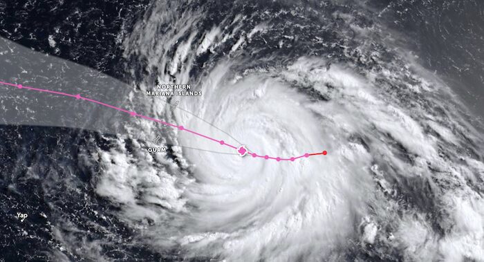
GNWS forecasters are expecting sustained winds of 150 kts (277kms/hour) with gusts to 180 kts (330kms/hour) and seas of up to 45 feet near the storm center.
However, there GNWS forecasters said there was still uncertainty as to which islands will receive the strongest impacts due to irregular longitudinal shifts in motion.
“The latest model guidance continues to indicate a path near or just north of Rota, but the forecast track will continue to change over the next 24 hours. All of the islands will see impacts, but the islands closest to the storm center passage will experience significantly worse conditions. Secure all vessels. Conditions are expected to be catastrophic for small craft, and extremely dangerous for any vessels of larger size,” the GNWS posted on their website.
The warnings as Bavi approaches come as some residents were still without electricity following super typhoon Sinlaku which battered the Marianas and Guam in April, causing widespread devastation to local infrastructure and the economy and wiping out up to 60 percent of the livestock on Saipan.
Strongest on Earth this Weekend
Super Typhoon Bavi remains the strongest storm on Earth this weekend as it churns through the western Pacific Ocean and is the western Pacific’s second super typhoon of 2026 according to the Weather Network.
Several powerful typhoons have affected these islands in recent years. Super Typhoon Yutu brought widespread destruction when it directly struck the Northern Marianas in 2018 and Typhoon Mawar caused further damage to the region in 2023.
Super Typhoon Bavi is the world’s third Category 5 equivalent storm so far this year. The first was Tropical Cyclone Horacio in the southern Indian Ocean in February, followed by Super Typhoon Sinlaku in April.
Above Normal Activity Predicted for Remainder of 2026
NOAA’s Western North Pacific (WNP) Tropical Cyclone Outlook for the remainder of 2026 was for above-normal activity for the Federated States of Micronesia (FSM), the Republic of the Marshall Islands (RMI), the Commonwealth of the Northern Mariana Islands (CNMI) and the Territory of Guam and below-normal to normal activity for the Republic of Palau (ROP).
The outlook said above-normal activity was consistent with the anticipated shift to El Niño as supported by the latest National Oceanic and Atmospheric Administration (NOAA), National Weather Service (NWS) ENSO Diagnostics Discussion. This is likely to result in considerably more regional activity than seen in the past several years. An eastward shift in TC genesis is predicted to keep TC activity near or below normal across the ROP, with more TCs passing to the north. TC activity will vary considerably from east to west and north to south due to the large extent of the Micronesia region.
…………………………………
Related News:
- Northern Marianas Warned to Prepare for Super Typhoon Bavi (Radio New Zealand)
- Super Typhoon Bavi is one of Earth’s Strongest Storms in 2026 (The Weather Network)
- NOAA – NWS Western North Pacific Tropical Cyclone Outlook 2026
…………………………………
Related Links:
- Guam National Weather Service
- Joint Typhoon Warning Center
- Zoom Earth – Satellite Images
- National Oceanic and Atmospheric Administration
- National Weather Service – Climate Prediction Center – ENSO Diagnostics Discussion
…………………………………
Find out all news, reports, links and comments posted on Noonsite, plus cruising information from around the world, by subscribing to our FREE monthly newsletter. Go to https://www.noonsite.com/newsletter/.
If you have found this information useful, become a paid member to enjoy unlimited use of Noonsite plus many other perks. Your membership fees really help our small, dedicated team keep country information up-to-date in support of cruisers worldwide. Find out more about Noonsite Membership levels and benefits here.
Leave a comment
You must Login or Register to submit comments.