
Earth Sciences New Zealand has installed a new Tsunami Monitoring Buoy in the South Pacific, east of Raoul Island in the area of the Kermadec Trench, according to a recent New Zealand Notice to Mariners.
Raoul Island is located in the South Pacific Ocean, about 1,100 kilometres (680 miles) northeast of New Zealand’s North Island. It is the largest and northernmost of the Kermadec Islands and sits roughly halfway between New Zealand and Tonga.
The new buoy is part of the Deep-ocean Assessment and Reporting of Tsunami project (DART) – deep-ocean instruments that monitor changes in pressure and allow scientists to detect and measure a tsunami before it hits New Zealand and other South Pacific nations.
The newly installed buoy is located in the area of the Kermadec Trench which is the southern section of a very active line of plate tectonic collision that extends over 2,500km from New Zealand to Tonga according to Earth Sciences New Zealand.
- Characteristics are: FL Y. 2s 1M ‘F’. i.e Flashing Yellow every 2 seconds, visible from 1nm and has the letter F on it
- Position: 29 40.5S, 175 00.57W
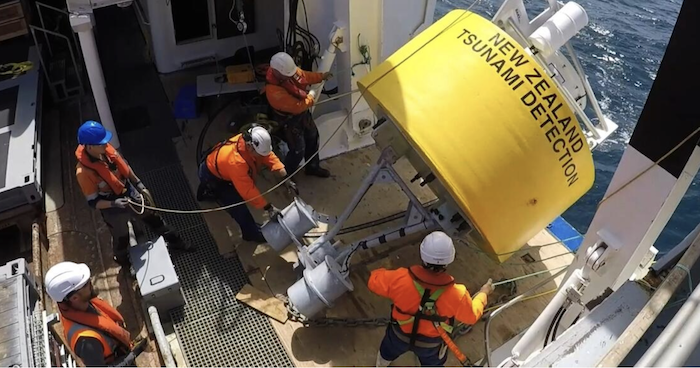
New Zealand uses a network of 12 DART (Deep-ocean Assessment and Reporting of Tsunami) buoys to monitor and detect potential tsunami waves in the Southwest Pacific.
The stations are deployed off the east and north coasts of New Zealand in the Southwest Pacific, close to the Hikurangi, Kermadec, Tonga and South New Hebrides trenches to provide early warning of tsunami waves that could reach New Zealand in less than a few hours.
The DART network is linked to GNS Science’s National Geohazards Monitoring Centre (NGMC) and Rapid Characterisation of Earthquakes and Tsunamis (RCET) automated analysis system in Wellington, New Zealand and provides data to the Pacific Tsunami Warning Centre (PTWC) in Hawaii and the IOC sea level monitoring website to support early and more informed warnings of tsunami threats to trans-Pacific coastal communities.
………………………………
Noonsite thanks Alan Leslie from SV Elyse for alerting us to this information.
………………………………
Related News:
………………………………
Related Links:
- Earth Sciences New Zealand DART Buoys
- Pacific Tsunami Warning Centre (PTWC)
- IOC sea level monitoring website
………………………………
If you have found this information useful, become a paid member to enjoy unlimited use of Noonsite plus many other perks. Your membership fees really help our small, dedicated team keep country information up-to-date in support of cruisers worldwide. Find out more about Noonsite Membership levels and benefits here.
Subscribe to our FREE monthly newsletter: https://www.noonsite.com/newsletter/
Leave a comment
You must Login or Register to submit comments.