Guam residents woke up Thursday May 24 to survey the damage after a long night of whipping winds and lightning storms from Typhoon Mawar, that downed coconut and mango trees and knocked out power across much of the U.S. Pacific territory.
Mawar was upgraded to a super typhoon, meaning that its maximum sustained winds were at least 150 miles per hour, as the storm moved over open water. The storm had packed Category 4-level winds of about 140 miles per hour at “just prior to midnight” local time on Wednesday, as it passed over Guam, according to the National Weather Service.
Strongest in Years
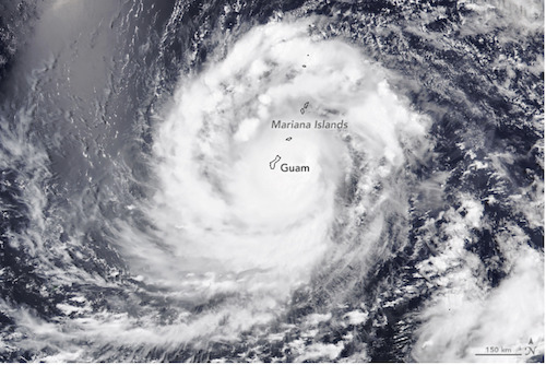
Mawar was the strongest storm to hammer Guam in years and was expected to continue to generate tropical storm-force winds before weakening on Thursday, the Weather Service warned. The storm had moved 105 miles northwest of Guam as of 11 a.m. local time, but typhoon warnings were still active.
There were no immediate reports of deaths or injuries, but the storm was so strong that it broke wind sensors and radar equipment that send meteorological data to the local Weather Service office.
The US National Weather Service said the slow-moving category 4 storm delivered rainfall of up to 5cm per hour overnight.
Even though the centre of the storm’s eye passed just north of Guam, most of the island lost power. Nearly all of Guam Power Authority’s circuits have been impacted by the storm and only about 1,000 of its 52,000 customers still had electricity, the authority said in a statement.
In an update early Thursday morning, the Service said the typhoon warning remained in effect for Guam and Rota Island in the Northern Marianas.
Update Saturday 27 May:
Tropical Cyclone Mawar intensified into a super typhoon on Friday 26 May after passing Guam, with winds peaking at 185 miles per hour, putting its strength at the same level as a Category 5 hurricane in the Atlantic and making it the strongest tropical cyclone in the West Pacific during the month of May on record and the strongest storm so far in 2023. The storm has since weakened slightly and may fluctuate in intensity into the weekend. By the time the storm approaches the Philippines on Sunday, forecasters expect it to weaken further.
NASA Mission to Help Learn More about Cyclones and Typhoons
On May 25, NASA was due to launch its TROPIC mission, the data from which scientists hope will help them learn more about tropical cyclones like Mawar.
The final launch of NASA’s Time-Resolved Observations of Precipitation structure and storm Intensity with a Constellation of Smallsats (TROPICS) mission is targeted for no earlier than 12 a.m. Eastern Time on May 25. The shoebox-sized satellites are designed to collect information about temperature, precipitation, water vapor, and clouds—data that can provide insight into storm formation and intensification.
………………………………..
Related News:
- Landslides, flash flooding warnings as typhoon passes over Guam (Radio New Zealand)
- Mawar Gains Strength after thrashing Guam, becoming a Super Typhoon (New York Times)
- Guam Smashed by Typhoon Mawar (Australian Broadcasting Corporation)
- Typhoon Mawar – NASA
………………………………
Find out all news, reports, links and comments posted on Noonsite, plus cruising information from around the world, by subscribing to our FREE monthly newsletter. Go to https://www.noonsite.com/newsletter/.
Leave a comment
You must Login or Register to submit comments.