
What is Sargassum?
Sargassum is a free-floating brown seaweed that forms large mats on the surface of the ocean. It provides an important habitat and food source for marine life offshore, but when large quantities wash ashore they can create significant problems for coastal communities, beaches and tourism.
For cruising sailors, however, the main concern is what happens offshore. Large floating patches can extend for miles and may be encountered during an Atlantic crossing or on-route to the Caribbean, particularly in the Caribbean Sea and western tropical Atlantic. Dense mats can foul propellers, rudders, keels, water intakes and hydrogenerators, while forcing yachts to slow down or divert around particularly heavy concentrations.
A major Sargassum year in 2026
Satellite monitoring shows that 2026 was the second-highest Sargassum year on record for the Great Atlantic Sargassum Belt, behind 2025. The annual peak occurred in June, when particularly large concentrations were recorded in the Caribbean Sea and Gulf of Mexico.
NASA observations reported around 3.6 million metric tons in the western Caribbean, 9 million metric tons in the eastern Caribbean and 5 million metric tons in the Gulf of Mexico during June. The Gulf’s June concentration was almost twice its previous June record, set in 2025.
Sargassum abundance subsequently declined through July and into the later summer. However, substantial quantities remain in the Caribbean and western Atlantic. Mexican monitoring continues to show significant concentrations in the region, with daily satellite-based tracking available to help identify where the largest concentrations are located.
This means that sailors planning an Atlantic crossing should not assume that the end of the summer peak means the problem has disappeared.
What does Sargassum look like at sea?
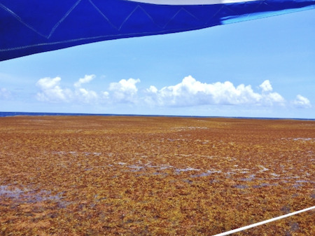
The amount of Sargassum encountered can vary enormously. Individual pieces or small clumps may be scattered across the surface, while larger concentrations can form dense rafts extending for several nautical miles.
Conditions can also change quickly as the weed is moved by ocean currents, winds and waves. A yacht may therefore pass through relatively clear water and then encounter a much denser concentration further along its route.
Why should offshore sailors care?
Heavy concentrations can create several practical problems for yachts:
- Loss of speed: Dense mats can create considerable drag. Yachts have reported severe reductions in speed when travelling through heavy concentrations.
- Fouling: Sargassum can become wrapped around propellers, rudders, keels, shafts, struts and other underwater equipment.
- Blocked intakes: Weed can obstruct seawater intakes and strainers, potentially affecting engine cooling and other onboard systems.
- Hydrogenerators: These can be particularly vulnerable to entanglement. A fouled unit may stop producing power and need to be raised or cleared.
- Extra maintenance: Crews may need to stop and clear weed manually, sometimes repeatedly if travelling through a heavy concentration.
- Route and passage-time changes: Where significant concentrations are forecast, skippers may choose to alter their route or allow additional time for the crossing.
The problem is not necessarily that a yacht will encounter an impenetrable “wall” of weed. Rather, large concentrations can make a passage more difficult and may require active monitoring and occasional intervention.
Check Sargassum before leaving
Sargassum is monitored using satellite imagery and oceanographic models, giving sailors a useful indication of where concentrations are developing.
For an Atlantic crossing, it is worth checking the latest information before departure and during the passage, particularly if your route takes you through the Caribbean or western tropical Atlantic.
Useful resources include:
- USF Optical Oceanography Lab / Sargassum Watch System – provides Sargassum Outlook Bulletins and satellite maps showing concentrations across the Atlantic and Caribbean.
- Météo-France Sargassum Bulletins – provides short-range Sargassum risk assessments, particularly useful for approaches to islands in the Lesser Antilles.
- Mexican Navy / Instituto Oceanográfico del Golfo y Mar Caribe – publishes daily Sargassum monitoring and forecasts for the Caribbean.
Satellite products are useful for identifying large-scale concentrations, but they cannot necessarily tell a yacht exactly what it will encounter at sea. Conditions can change as floating mats move with currents and wind.
Be prepared to clear fouling
If your planned route could take you through areas of heavy Sargassum, make sure you are prepared to deal with fouling.
Useful preparations include:
- having a boat hook or similar tool readily available;
- knowing how to inspect and clear rudders, propellers, shafts and other underwater equipment safely;
- checking the location and accessibility of engine and seawater intake strainers;
- being prepared to stop and clear a fouled hydrogenerator;
- carrying whatever equipment is normally required on your boat to deal with underwater fouling; and
- allowing some flexibility in your passage plan if heavy concentrations are encountered.
Sargassum on arrival
For sailors heading into the Caribbean, the problem can become particularly noticeable once approaching land.
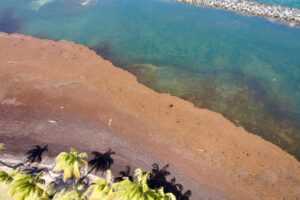
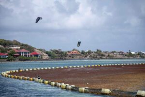
When large quantities wash ashore and begin to decompose, they can produce a strong smell and create substantial accumulations along beaches. Several Caribbean and Mexican destinations have therefore installed Sargassum barriers designed to intercept or divert floating weed before it reaches the coast.
These barriers can themselves affect navigation and water activities, so check local information before approaching affected bays.
Saint-Martin
The Collectivité de Saint-Martin is installing anti-Sargassum barriers in Cul de Sac Bay and Embouchure Bay. Installation of two barriers in Cul de Sac Bay, near Pinal Island, began in September 2026. Anchoring, swimming and nautical activities are prohibited within the designated zone, with penalties for violations.
Read more: Saint-Martin restrictions on Noonsite.
Saint Barthélemy
A trial Sargassum barrier is being tested near Marigot, with adjustments being made as authorities assess how best to position and anchor the system. Further barriers are expected to be considered for Anse des Cayes and Cul-de-Sac if the trial proves successful.
Read more: Sargassum: Adjustments to the Barrier Trial in Marigot – Le Journal de Saint Barth
Martinique
Doyle Guides report that a new 750 metre floating barrier has been put into service near Le François, Martinique, to help reduce the amount of sargassum reaching the shoreline. Installed off the Frégate area, the barrier is designed to intercept incoming sargassum before it washes ashore and is being checked regularly for debris and other hazards. For sailors familiar with the impact sargassum can have on Caribbean coastlines and anchorages, it is an interesting look at how Martinique is responding to the problem. See more here.
The bottom line for Atlantic sailors
Sargassum is a natural part of the tropical Atlantic ecosystem, but unusually large blooms have become a significant consideration for yachts cruising the region.
For sailors preparing to cross the Atlantic, it is worth adding Sargassum to the pre-departure checklist. Check the latest satellite information, understand where the major concentrations are located, make sure you can deal with fouling, and keep some flexibility in your route and expected passage time.
For the latest monitoring information, see the USF Sargassum Watch Project and Météo-France Sargassum Bulletins.
See all Noonsite Sargassum content and resources.
…………………………………
Related News
- USF scientists will explore the drivers of sargassum blooms through $1.5 million collaborative research project (University of South Florida)
- Great Atlantic Sargassum Belt records second-largest year in 2026 (The Watchers)
- Sargassum: Adjustments to the Barrier Trial in Marigot (Le Journal de Saint Barth)
- Sargassum Seaweed: Turning a Problem into a Solution (Noonsite)
…………………………………
Related Links
- Noonsite Sargassum Content and Resources
- USF Optical Oceanography Lab
- Météo-France Sargassum Bulletins
…………………………………
Noonsite has not independently verified this information.
Find out all news, reports, links and comments posted on Noonsite, plus cruising information from around the world, by subscribing to our FREE monthly newsletter. Go to https://www.noonsite.com/newsletter/.
If you have found this information useful, become a paid member to enjoy unlimited use of Noonsite plus many other perks. Your membership fees really help our small, dedicated team keep country information up-to-date in support of cruisers worldwide. Find out more about Noonsite Membership levels and benefits here.
Leave a comment
You must Login or Register to submit comments.