Life-threatening Surf and Rip Currents Expected
However, in an advisory, the NHC said ocean swells generated by Humberto will begin affecting portions of the northern Leeward Islands, the Virgin Islands, Puerto Rico, and Bermuda over the weekend. These swells are likely to cause life-threatening surf and rip current conditions.
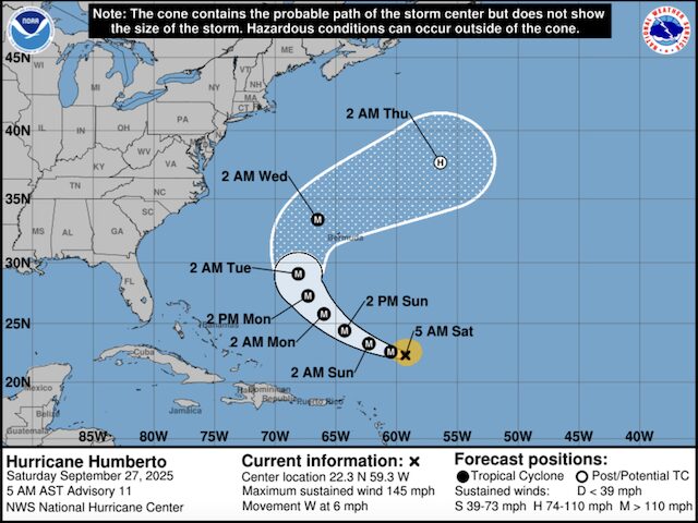
While Humberto is the eighth named storm of the 2025 Atlantic hurricane season it is – so far – just the third to gain hurricane intensity says the NHC.
Humberto is moving to the northwest and should stay well east of South Florida and the United States East Coast with no direct impacts to land.
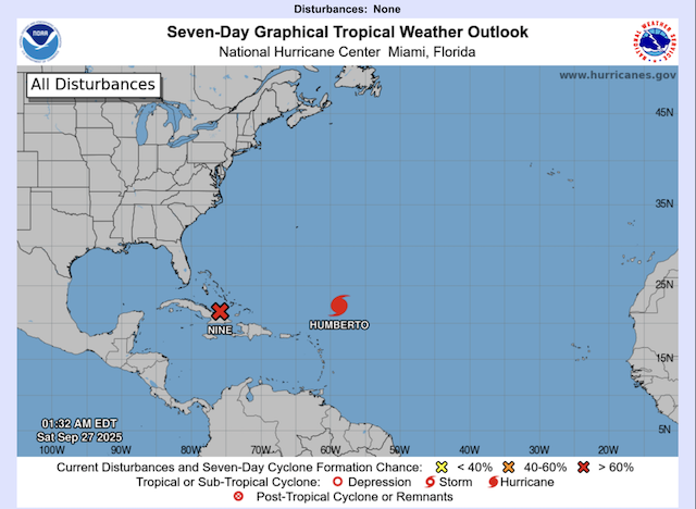
Hurricane Humberto is one of two weather systems in the Atlantic, the other is an area of low pressure that is bringing widespread thunderstorms to Haiti, Dominican Republic and the Turks and Caicos Islands.
Forecasters say this low is likely to develop into a tropical depression and then into tropical storm ‘Imelda’ over the weekend as it moves into the Bahamas.
The Fujiwhara effect
Forecasters are watching these two Atlantic storms closely because they could evolve into one of meteorology’s most unusual and rare events – The Fujiwhara effect – which occurs when two storms interact with one another, about 900 miles apart, according to the National Weather Service. The closer the storms get, the greater the effect, which is named after Sakuhei Fujiwhara, the Japanese meteorologist who first described the effect.
At first Hurricane Humberto and the developing storm will be far enough apart to grow and move independently of one another, but Humberto is moving much more quickly and by early next week could be close enough to have a big influence on the developing storm’s track and potential strength.
BBC Weather Presenter Chris Fawkes outlined three scenarios that could occur between Hurricane Humberto and the yet to be named Tropical Storm Imelda.
- Firstly the developing, deepening low could become very slow-moving effecting the western Bahamas for a number of days before moving out to sea.
- Secondly, it could make landfall around Georgia and South Carolina in the US bringing flooding rain and damaging winds here.
- Alternatively, an area of high pressure could block the low from reaching the US coast and instead it just stays out to sea.
Above-Normal 2025 Hurricane Season
The National Oceanic and Atmospheric Administration (NOAA) forecast an above-normal 2025 hurricane season predicting between 13 and 18 named storms, of which five to nine were expected to become hurricanes.
Erin was the first and while she didn’t make landfall, grew to a ferocious Category 5 hurricane, causing strong winds, dangerous rip currents and flooding along parts of the East Coast of the United States. Historically, on average, hurricane and tropical storm activity peaks on September 10, but this year has been quieter than expected when it comes to tropical systems in the Atlantic said NOAA.
…………………………………
Related News:
- National Hurricane Center Humberto Advisory
- Hurricane Humberto Strengthens Into a Category 4 Hurricane (CBS News)
- Hurricane Forecasters Watch for rare chaotic Fijiwhara Effect (USA Today)
- Second Storm Could Dance with Humberto (BBC)
…………………………………
This content was compiled by Noonsite from various sources.
If you have found this information useful, become a paid member to enjoy unlimited use of Noonsite plus many other perks. Your membership fees really help our small, dedicated team keep country information up-to-date in support of cruisers worldwide. Find out more about Noonsite Membership levels and benefits here.
Subscribe to our FREE monthly newsletter.
Leave a comment
You must Login or Register to submit comments.