COVID-19 Field Report: 4,200kms through the Med

Johan and Tove on board SY Bird of Passage left Port Ghalib, Egypt on 18 April and arrived in Gibraltar on 27 May after 4200 kms (2500 miles). They were not allowed to go ashore anywhere during their transit through the Med due to COVID-19 restrictions. The following report details their journey.
Published 5 years ago
Finally we were in the Med again, a great feeling after so many years in foreign waters.
First stop Greece
As soon as we left the Suez canal we raised our sails and headed for Crete but the wind took us north and eventually we had to start an engine to go west. After 2 days motoring we could sail again and slowly we advanced against the wind and arrived to Iera Petra on Crete after 5 days and 500 NM. The real distance “as the crow flies” is 400.
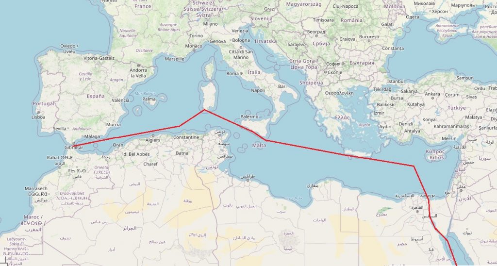
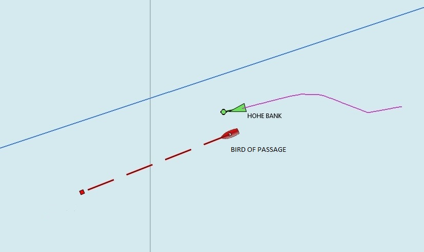
- SY Bird of Passage’s route across the Mediterranean.
Now there was only one problem. We could not enter the harbour and we could not go ashore. Greece, and most other countries, had introduced strict rules for yachts at sea because of Corona. I talked to the Coast Guard in Iera Petra on radio and they said we could anchor 100 meter from the shoreline for a maximum of 48 hours. They even sent me an e-mail. Here it is:
Good evening sir from Ierapetra Coast Guard.
As you know due to Covid-19 current restrictions we cannot allow any vessel approach in our port and disembarkment. We inform you that you are allowed to stay on anchor in the sea area of Ierapetra for a period of time not longer than 48 hours. Also we inform you that you must have an agent to take care for all that you reguest because our small port doesn’t have permanent petrol installation -super market-technical installation. There is one local agent Mr. SIGANOS Ioannis you can contact (email: anakozatravel@gmail.com; tel: 6987848366 or 6906695282). Finally, we forward you a form(ΔΗΛΩΣΗ ΥΓΕΙΑΣ -DECLARATION OF HEALTH) you have to fill in and send it back to us before arrival. We also require from you to email us your vessel documents, (registry, ship particulars) a crew list and a copy of your passports end insurance. You can contact us on VHF channel 12 for any information as well as notify us for the time of your arrival and anchor drop.
Thanks for the cooperation
Very polite, but they didn’t mention the fact that the “agent” charged 150€ for his service and that they did not have water good enough to drink. Also did they not mention that there was a terrible swell where they wanted us to anchor. It’s strange that a proud sea nation like Greece can treat visiting yachts so badly. But we are not the only ones. Through various networks we now get reports from all over the world about cruisers who have been stopped to come into ports or marinas. And some are in a really bad state. Low on water, food, diesel and need of reparations on sails, rudder and motors. Also elderly single-handers who have been long at sea and boats with children, like us.
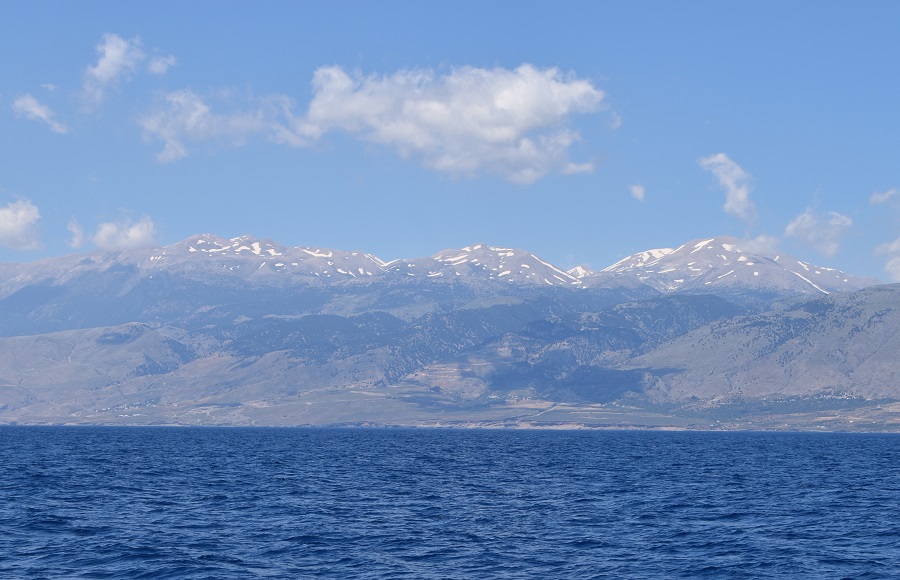
- A view of Crete’s snow-capped mountains in the distance.
Snow on the Mountains
Crete is a high island with tops over 2400 meters. This time of the year there is still snow up there while farmers are growing vegetables in greenhouses down by the sea level. Large areas of the south coast of Crete are covered by the white greenhouses that you see in the picture above.
From Ierapetra we motored against the strong westerly wind first to Kalio Limenes where we spent one night and then to Ormos Loutro. A fantastic little bay with a beach and hotels around it. But totally empty. No tourists.
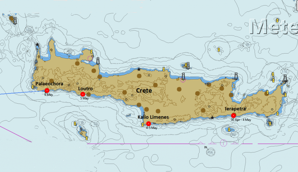
- SY Bird of Passage could stop along the coast of Crete, but could not go ashore
It would have been nice to be able to visit Crete more in detail but the government would not let us. Instead we set sails again, this time for Sicily, about 500 NM. The forecast promised plenty of wind.
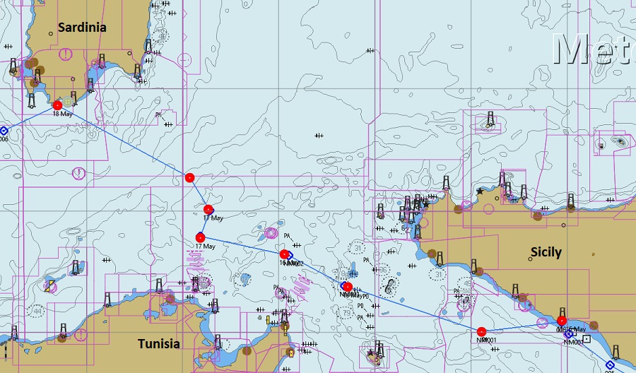
- Our track from Sicily to Sardinia.
The South Coast of Sicily
Two days of good sailing and two more days of very light winds with motorsailing and we arrived to Licata on the south coast of Sicily.
We needed water most of all as we had not been able to fill our tanks since Port Ghalib in Egypt 3 weeks earlier. We also wanted to buy food and diesel that would last until we reached our next stop, Gibraltar, 1000 NM west of Sicily. A long trip that would take more than a week.
As we came into the harbour, the Coast Guard told us to go into the marina and a marinero would show us where to tie up. He put us alongside a lonley pontoon with no other boats and then gave us a paper to read, see above. Once again, we were not allowed to go ashore but worse, there was no diesel. The good news was that an Inspector would come and after that we would be able to go ashore. We waited and we waited, but nothing happened that day.
The next day I started sending e-mails to Maria at the “Hospitality Desk” . Where is the inspector, where is the marinero that will help us with the shopping and where can we get diesel if not in the Marina? She did not answer any of those questions, instead she instructed me to translate the shopping list to Italian and send it with Whatsapp directly to the supermarket. Impossible, no one on the boat speaks Italian and still no Inspector and we could still not go ashore. Now I got really irritated. I sent an e-mail to the Coast Guard with complaints about the situation, and copies to the Swedish Consulate in Palermo and the Swedish Foreign Ministry in Stockholm. Two hours later the Coast Guard arrived with our food and told us that we would get diesel the next day in jerrycans, which we also did. Water was available on the pontoon and included in the Marina fee, 75€/day! Corona is expensive.
We never saw any inspectors and we were never allowed to go ashore. Italian chaos I would say. I wonder if my e-mail to the Coast Guard had any effect. Maybe it did!
Next leg to Gibraltar
Now there was only one leg left to sail and we would be out of the Med and in to the Atlantic. But not an easy voyage. Long (1000 NM), very unpredictable winds with many calms. I sent an e-mail to the port in Gibraltar before we left to announce our arrival and they answered that I must have a confirmed booking in a marina to be allowed into the harbour. I mailed Queensway Marina but they were full, and then I gave up and we left Sicily.
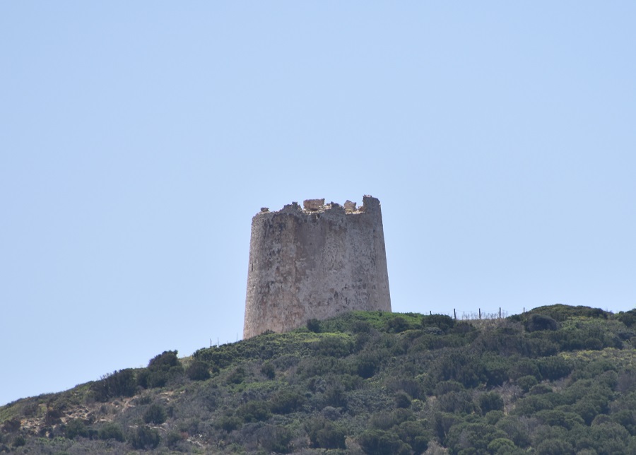
- Stone Tower high on a cliff above the shore in Sardinia
Waiting off Sardinia for better winds
The weather forecast was not good but acceptable, at least to begin with. First no wind, then strong wind from behind and then after two days wind that forced us to head north. After 3 days we anchored west of Cape Spartivento on the south coast of Sardinia. Here we could stay and wait for better winds.
The first thing we saw where we anchored was a stone tower that seemed very old. It reminded us of something we saw many years ago on Shetland called a Broch. Here they call them Nuraghs but they seem to be very similar. Old stone fortresses where people gathered for protection in bad times. One book we have says Stone age and one says Bronz age. Those on Shetland are said to be Iron age.
Sitting on anchor, waiting for weather and not being allowed to go ashore gives you time. Tove contacted a journalist on one of the two daily newspapers on Aland and asked him to write something about the bad situation for sailors not being welcome in any port. A few days later he mailed us his article, see below. Nice to know that people at home care.
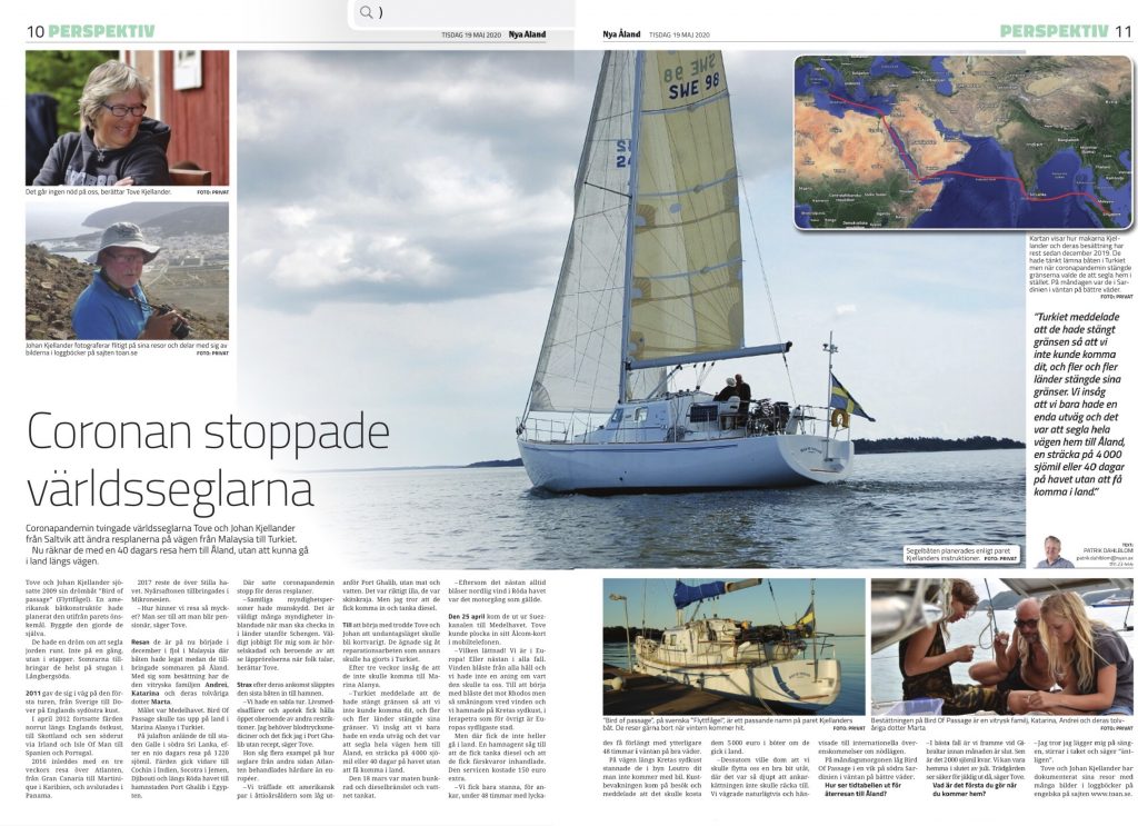
- Our voyage featured in a local newspaper back home.
On to Gibraltar after three days at anchor
After three days of anchoring on the coast of Sardinia the weather forecast finally promised better winds. We could now continue towards Gibraltar, 700 NM west. First day, good sailing, then motoring in calm for a day and then strong winds from behind. 140 NM/day for two days. After 1000 NM from Sicily we were finally in Gibraltar. 12 days at sea including 3 days anchoring on the coast of Sardinia.
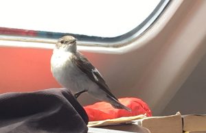
- One of the many avian hitchhikers along the way.
40 Days on board
From Egypt we had now sailed 2000 NM. Half way home. That felt nice. Also, we were now in waters that we had sailed before. For me it was the third time through the strait of Gibraltar on my own boat. The Atlantic coast of Europe felt like home waters. We all hoped very much that Corona restrictions would be lifted so that we could visit some of the places on our way home that we had found to like on earlier voyages.
We had now been on the boat for 40 days without being permitted to go ashore anywhere. Not nice. 40 days on the boat gives you time to take some bird pictures and to try out some new interesting functionality of OpenCPN.
I lost count, many years ago, of the number of birds that have landed on the boat far out at sea. Many also come inside. A few have been wounded and clearly searched for shelter. Others have probably only been tired and some just want to sit during the dark hours of the night. The one to the left above, joined us at daytime for a few hours and then left. The swallow to the right above, came on board as the sun went down and spent the night on a shelf where I keep some tools.
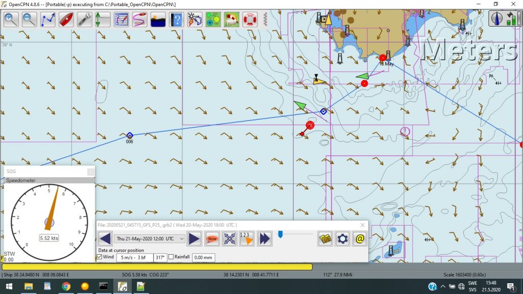
Fresh weather forecasts
For a long time I have not been able to use my HAM radio for E-mail because there were no Winlink-stations to contact. At least not in Asia it seems. Now in the Med when I tried the radio, there were lots of stations to choose from. I called a station in Bulgaria, LZ3CB, and it responded immediately. For the first time I could now also try the new ARDOP digital radio mode recently released, so I downloaded a 7 kB GRIB weather forecast file to see how fast it was. As you see in the picture above the mean throughput was about 1.500 bytes per minute. This means a 3-day GRIB for the Med takes less than 5 minutes to download. A good feeling to know that we now can get fresh weather forecasts every day and without any cost. Winlink is free to use for Radio Amateurs.
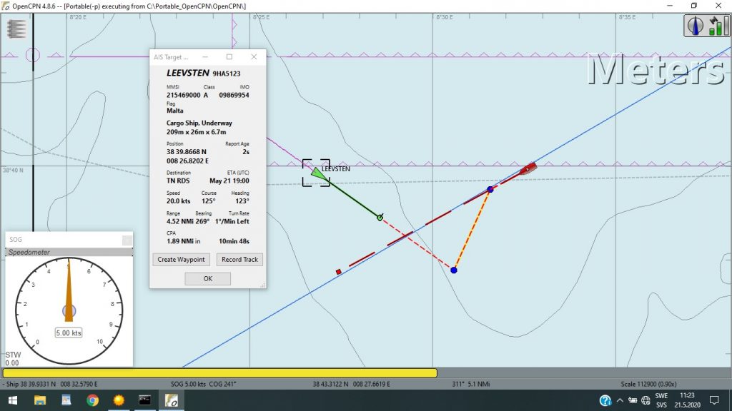
- Using AIS to avoid collisions in the Mediterranean.
Using AIS to avoid collisions
We have had our AIS now for one and a half year. I was skeptical to begin with, but have slowly become more and more satisfied and this is for one reason. The TCPA-function in OpenCPN, which uses data from our AIS to calculate the Time for Closest Point of Approach (TCPA) which is very nice to know when you meet a ship at sea. On your chart (pictured above) you will see yourself (red) and the ship in question (green) and also the point (blue) when you will be closest to each other, ie. the CPA. Red/yellow dotted lines connect you and the ship with the CPA and the grey window tells you when it’s going to happen, ie. the TCPA.
 The picture to the right shows a situation where the CPA indicated that there was risk for collision. One of us, or both, must alter his course. I usually try to wait as long as possible and hope that the other one will change course first. It’s much easier for him than for me with sails rigged for a specific wind direction. In this case he turned starboard to come on my starboard side with good space between us.
Another feature in OpenCPN that I use a lot is the GRIB-file overlay. GRIB-files contain weather forecasts and you can download them free from Internet. At sea, I use my HAM-radio to download them (also free). Displaying them on the OpenCPN-chart is a convenient way to plan a voyage for the next few days. You see the forecasted wind direction and force and you can then estimate what daily distances you will do under those conditions.
So that was the end of our voyage in the Mediterranean in 2020.
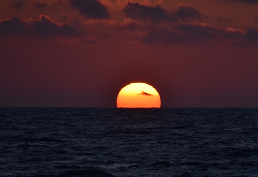
- Mediterranean Sunset
Tove and Johan Kjellander
SY Bird of Passage
…………………………………………………………………………………………………………………………………..
Related Links:
…………………………………………………………………………………………………………………………………..
Please share your current experience with COVID-19 restrictions and how it has affected your cruising plans. Contact Sue at editor@noonsite.com with your field report.
…………………………………………………………………………………………………………………………………..
The opinions expressed in this article are the author’s own and do not reflect the view of Noonsite.com or World Cruising Club.
Related to the following Cruising Resources: COVID-19, Cruising Information, Mediterranean, Routing
Comments