St. Vincent and the Grenadines: Quiet Volcano and Quiet Anchorages

It’s all quiet in St Vincent and the Grenadines with St Vincent’s La Soufrière volcano entering a quieter phase and life in the islands getting back to post COVID normal. This report by Chris Kennan of AllatSea.net.
Published 4 years ago
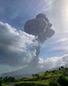 After months of unrest, the La Soufriere violence erupted on April 9, 2021. The volcano exploded violently, covering St. Vincent, the Grenadines and Barbados with ash fallout. Now, the volcano eruption phase has been classified as “orange”, down from “red” eruptive levels – although this could change at any time.
This event is being continuously monitored by the University of the West Indies, St. Augustine, Trinidad and Tobago, Seismic Research Centre (UWI-SRC). The center is the official source of information for earthquakes and volcanoes in the English-speaking Eastern Caribbean.
Scientists are observing for possible changes, however, the St. Vincent situation seems stable per reports from http://uwiseismic.com.
Quiet Anchorages
Meanwhile, stores, restaurants and cafes are open, wifi works, and boats are on anchor in Bequia harbour and southern anchorages of St. Vincent. The Tobago Cays and the rest of Grenadines, due to the COVID situation, are experiencing low occupancy. In the Grenadines, where it was hard to anchor in the past, few boats swing at anchor; it’s back to the 1950s-60s flavor for the now-quiet anchorages.
The only place vessels can clear into St. Vincent and the Grenadines is Young Island/Blue Lagoon. Boats arriving from other foreign ports must go to St. Vincent first. However, as of May 2021, there are no issues there, cruisers are reporting enjoying other St Vincent anchorages such as Cumberland. Boats are being told to avoid the northern part of the island, whether for stopping or even sailing close to shore.
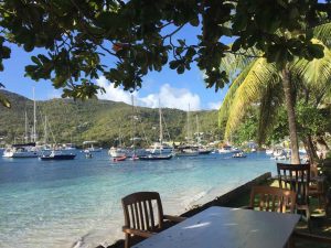
- Bequia – St. Vincent and the Grenadines
Currently, for passage around St Vincent, boats should be aware to give leeway around the northern red zone. Approximately the northern one third of the main island is under Orange alert due to possible ash venting; but the main concern is due to lahars.
Lahars – mudflows with large rocks, trees and debris – can move at miles per hour and scour out river beds, buildings, towns, land and roadways. These lahars, have reached all northern coastlines such as Sandy Bay on the east, on the west and on the north sides of the ‘red zone.”
Watch out for Floating Debris
Most recent flows are caused by rain washing down loose debris and ash from the volcano slopes. The concern of the danger is clearly indicated by the warnings in the weather reports provided daily by St Vincent’s National Emergency Management Organization (NEMO). Additionally, vessels should plan to keep a watch for debris in the waters around the island. Trees or lumber or other floating objects and passaging vessels do not mix well.
To read the full report from AllAtSea, Click Here.
………………………………………………………………………………………………………………………………………….
Related News:
Noonsite: Emergency Solar Light Campaign Underway
Noonsite: La Soufriere Volcano Erupts
………………………………………………………………………………………………………………………………………….
Related Links:
- St Vincent’s National Emergency Management Organization (NEMO).
- University of the West Indies, St. Augustine, Trinidad and Tobago, Seismic Research Centre (UWI-SRC)
…………………………………………………………………………………………………………………………………………
The opinions expressed in this article are the author’s own and do not reflect the view of Noonsite.com or World Cruising Club..
Related to following destinations: Bequia, Grenada, Mustique, St. Vincent, St. Vincent & the Grenadines, The Grenadines
Related to the following Cruising Resources: Atlantic Crossing, Caribbean Sea, Routing
Comments