The Marshall Islands is made up of 29 atolls, 5 islands and 1,225 islets which form two major islands chains: The eastern Ratak (‘towards dawn’) and the western Ralik (‘towards sunset’) island chain. Ranked the fourth-least visited country in the world, the Marshall Islands is perhaps the last frontier of yachting with pristine vibrant ecosystems.
There are still two ports to clear in to Marshall Islands, Majuro and Ebeye.
We cleared in at Majuro and out at Ebeye.
Clearing out at Ebeye (see notes further down) saves beating against the wind all the way down to Majuro after visiting the north islands of Rongerik, Rongerap and Bikini. It’s still a leap of faith doing so, because we couldn’t get a cruising permit for Ebeye, but I hardly think that they will refuse to clear you out if you are there (they may just say you are not allowed to cruise around in the atoll). Just be nice, polite and smiling of course!
MAJURO
Clearing in:
Clearing in at Majuro was painless and fast. You still need to give them a pre-arrival notice. When arriving in Majuro you have to contact customs by e-mail or phone and arrange a time to meet them on your boat. You can always ask another boat to help you.
There is a net every morning at 07:30 on Channel 71. You can ask anything you need to know there. On Tuesday there is a cruiser’s dinner at a local restaurant. Ask any sailor to show you which restaurant and where it is. The dinner is popular both for expats working in Majuro and yachties. It’s a good way of getting to know everyone and get new friends.
Main pass:
We had a big swell coming with us when we went through the pass. It looked really scary with breaking waves all over the place but, going through was actually not bad at all. Our charts were very accurate. All green beacons were in place, but two red beacons were missing.
Anchoring and mooring – Majuro town:
The two mooring fields still exist, but I don’t know if the moorings are maintained and nobody else seems to know either. When you arrive, ask around the other boats which mooring to take and they will show you. Always try them out and dive on them.
Useful Local Information:
Groceries
There are big grocery stores in Majuro but I wouldn’t say they are good. The best one by far is K&K. Look for expiry dates and bugs on everything you buy. When we were there the flight stopped coming to Majuro so every store was totally out of vegetables, but after a few days a container ship arrived with some vegetables.
Water
We filled up with water on Ebeye (see Ebeye info. further down).
Medical
There is a Filipino private doctor in Majuro. It’s really hard to find him, ask any other yachtie or ask at the store “Island eco” and they will show you. The doctor is very good in English and he is very helpful. A visit costs US$20.
U.S. Embassy
Some friends of ours succeeded in getting their B1, B2 visas for USA at the embassy here. They got an interview after only one week of waiting. This has been more or less impossible anywhere else. In Panama you had to wait for over one year to get it, so if you are planning to stop in USA on your travels – get your Visas here.
Telephones and cell phones
You can buy a sim-card at NTA which is the state telephone company. Internet is very good in Majuro, but in Ebeye the signal was very weak. There is no coverage in Rongelap, Ronelip or Bikini. Bikini and Rongelap have telephone masts but they haven’t been working for years.
Most phones (at least iPhones) are NOT compatible with the sim-cards from NTA. Don’t ask me why! We had to buy a small wifi-unit and use that as a router. The unit costs 75 dollars, and that works. They have some different offers for data (approx. 15 gb for 25 dollars, 50 gb for 50 dollars and one month unlimited data for 70 dollars).
At the time when we were there was no cargo flights coming or going at all. Almost all packages going to Majuro were stuck in Guam and nothing worked. This had been the situation for several months. Before ordering anything to Majuro, talk to the expat community, they know if it’s worth the effort.
OUTER ISLANDS
I totally agree with previous writers, everyone should visit the outer islands, even if the paperwork is a headache. You need to have a lot of time and start the process way ahead of time for your cruising permits. You also need to remind officials many (many) times to actually get them. The moment you stop reminding them – they stop doing anything!
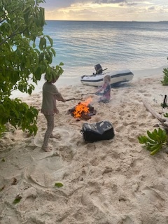
Our plan was to sail north from Majuro to the atolls north and west of Majuro – the Ratak Chain: Maleolap, Rongerik, Rongelap, Bikini and then down to Kwajalein and Ebeye to clear out. In this way we didn’t have to beat against the wind all the way back to Majuro. We ended up skipping Maleolap and sailed straight to Rongerik.
Before going to Rongerik and Rongelap, you have to get your cruising permit from internal affairs in Majuro. You also have to pay the fee (US$50) at the Rongelap town hall in Majuro.
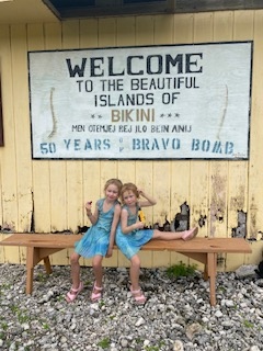
We got our permit for Bikini from the Consul of Bikini before leaving Majuro. You have to email the Consul yourself and ask. Make sure you explain that you are a private yacht with no passengers. The normal fee to visit Bikini is US$10,000 dollars (a little too much for our budget), but when I asked and explained that we are just a normal family and have no passengers, they reduced the fee to US$50 dollars and in exchange I wrote a short article with some pictures of our visit that the Consul could use for marketing.
Nobody asked us about our permit when we were at Bikini. We were supposed to pay the 50 dollars, but we had nobody to give the money to – so we ended up not paying.
Rongerik:
We arrived through the Eniwetak pass during the day in good light. There were no problems at all. After going through the pass we went around the corner and anchored outside Eniwetak Island on sand. The island is beautiful with nice sandy beaches, but it can be a bit uncomfortable if the wind picks up. On shore we saw a lot of signs of turtles nesting. We only stayed one night because it was a bit rolly.
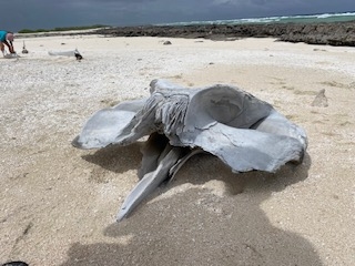
The next island we stopped at was Tarrowatt Island. This was also a bit rolly and didn’t really have any good protection. We only day-anchored here, but the island is very nice. There were hundreds of Boobies nesting with lots of baby birds. On the outside of the island there is a whale skeleton from some kind of big whale. I don’t know what kind it was, but it was fun to look at.
The best and most protected anchorage is at Rongerik Island in the northeast corner. We spent over a week here just exploring, snorkelling and hanging on the beach. On the middle of the beach some sailors have made a little area with a table and some old buoys hanging from the trees and called it Rongerik Yacht Club. From here we explored the close-by islands and found more nesting birds and turtle tracks.
We left Rongerik through the Back pass early in the morning heading for Rongelap. We motored through the lagoon just hoping not to hit any bommies in the bad morning light. But my feeling is that most bommies are shown on the charts or are very deep, we went straight over most of them. We were the only boat there and didn’t see any other human beings.
Rongelap:
We did a day sail from Rongerik to Rongelap arriving through the south pass. We went through the pass just in the middle of one of the worst squalls we ever experienced. The rain was pouring down and we had no visibility. We anchored on sand just off the pier at Rongelap Island.
There are three men working and living on Rongelap. They are there for six months and then another three men will take their place. They have everything they need and a lot of food in big freezers. They were really nice and took us on a tour around the island in their pick-up.
They really wanted some new films and we copied as many as we could fit on their small flashdrive. They were so happy! We heard from several sources that it’s okay to eat coconuts, breadfruits and pandanus from Rongelap. The guys on the island gave us more than we could eat. There is also a tree with a small red fruit that looks like a bell and has a good juicy taste. Our girls just love them and the guys thought it was very funny to see them climb the tree and pick them.
There is a big airstrip and at least 50 houses on Rongelap, but everything is just empty, it’s a real ghost village. There is no internet on Rongelap. There is an antenna but it hasn’t worked for ages.
Before going to Rongelap and Rongerik you have to get your cruising permit from internal affairs in Majuro. You also have to pay the fee (US$50) at the Rongelap town hall in Majuro. The workers on Rongelap have nothing to do with the permits. This cruising permit is the easiest to get, because you can take the permit yourself to the Rongelap town hall and have it signed.
Bikini Atoll:
We did a night-sail from Rongelap to Bikini Atoll. Again we arrived in the Enyu pass in the middle of a squall and we took cover at Enyu Island. The pass is big and there are no problems. Enyu Island is the island with the airstrip, but no airplanes are going there at the moment. Everything looks very much abandoned.
We walked around the island and found quite a lot of abandoned houses; some of them weren’t even finished. Some of them had salt and pepper on the tables, it looked like the people just stood up and left one day. There is a good concrete pier where you can tie your dinghy.
The next Island we visited was Bikini Island. We anchored just off the village on the middle of the island in sand. There are three men working here as well. They were also very happy to get some new films on their flashdrive, James Bond movies were popular. The village here contains a workshop, some houses and an abandoned dive resort with an outside bar – but it’s all closed.
For the entire time we were on Bikini there was a dive boat anchored out by the sunken ships, but they never went ashore. The dive boats operate from Ebeye. We don’t scuba dive and our permit stated that we weren’t allowed to, even if we could. The sunken ships from the nuclear testing are fairly deep. After only one night outside the village we moved to the north end of Bikini Island and anchored just off the concrete pier. The coral was nicer and our girls love playing on the piers.
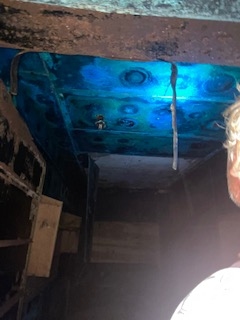
Our last anchorage in Bikini atoll was Romurikku Island. It’s the very north island in the atoll and if I understand everything correctly it’s the same island that is known as “Center Island”. I think this is the island were they detonated the Bravo Bomb. There are some old bunkers left on the island and I must recommend to bring a flashlight and walk inside them. The inner copper coatings have the most amazing blue colour, but it looks really poisonous. There were some birds nesting in the entrance.
We loved this island, there are lots of birds nesting and we saw turtle tracks. On the middle of the eastern part of the island there is a small sandy beach with no swell where you can land your dinghy with no problem. The beach is just amazing to hangout at and swim in the afternoon. We walked to the north west part where we think they detonated the Bravo Bomb. You couldn’t really see anything, but in the middle of the supposed crater was a big glass Japanese fishing ball. We got our permit from the Consul of Bikini before leaving Majuro. Nobody asked us about our permit when we were there. We were supposed to pay 50 dollars but we had nobody to give the money to so we ended up not paying.
There is no internet on Bikini, the mast hasn’t worked for ages. We were the only sailing boat there. You shouldn’t eat any coconuts, pandanus or breadfruits from Bikini Island; the radiation is still too high – but you can eat lobster and fish.
EBEYE
Cruising Permit:
We never succeeded in getting a cruising permit for Ebeye and Kwajalein atolls. They just didn’t answer. I heard about other sailors going there without a permit and having a lot of trouble. We went there anyway and had no problem clearing out from there at no costs. So we only stopped in Ebeye for a couple of days to provision and clear out. If we wanted to cruise around in the atoll it might have been harder.
Main Pass:
We went in and out of the atoll through the Gea pass on the west side of the atoll. The pass is very deep and well buoyed. We were told that it is also the pass the military use, but we didn’t see any other ships.
Clearing out:
Officially, to clear in or out on Ebeye you need a cruising permit from the Consul of Ebeye. We tried to get one to be able to clear out of Ebeye (you have to go through the “department of internal affairs” in Majuro), but we didn’t get any cruising permit so we went to Ebeye and cleared out there anyway – without any problems.
After arriving we went to the police station but they just told us to go to the Port authority instead. Port authorities have their office behind the big green building by the ferry docks. They share the house with the post office – the port authority is on the second floor and the post office on the first floor. It is hard to find so you might have to ask around.
The port captain had us fill in some paper and helped us in contacting customs, immigration and quarantine for clearing out. He was very nice but a bit surprised to see us. According to him we were the first boat there after Covid.
Custom, Immigration and Quarantine wanted to board our yacht, but everybody was very nice and fast and there were no charges. There are some dive boats that operate from Ebeye.
Useful Local Information:
Telephones and cell phones
You can buy a sim-card at NTA which is the state telephone company. NTA have an office here, by the antenna and you can top up your phone credit. When we were there they didn’t have any sim-cards, but we already had that from Majuro.
In Ebeye the internet signal was very weak.
Provisioning
Everything is kind of the same as written before, there is a Payless store and a store called Lucky Star. They didn’t have much and you have to check the expiry dates on everything. I bought flour, but I had to throw everything overboard because the bag was full of bugs.
Water
We filled up with water on Ebeye. There is a water tower in the middle of town with good, treated drinking water – and it’s free. Most people in Ebeye come there and get their water and its free to take for yachts too. It’s quite an exerience getting your water alongside the locals. You have to walk about 100-200 meters with your jerry cans from the ramp.
Fuel
We didn’t get any diesel and I’m not sure if you can. There is a petrol station that sells diesel by the big ramp, but the Customs guy said there was a lot of water in that diesel. I don’t know if he was serious or not.
Maria
SY Alice
……………………………..
About the Author:
We are the Lagerstrom family. When we not sailing around the world we live in Sweden on the west coast, close to some of the best cruising areas in Europe (if you ask us!). But right now we are sailing around the world and we just reached Yap in Micronesia. We have been out for two years and have reached a little more then half way around the world and our plan is to sail for one more year and come back to Sweden next summer.
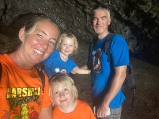
Our family is made up of Me, Maria, the mother and the skipper of our sailboat Alice, my husband Mark, the father and the mechanic and our two crewmembers Molly, eight years old and My who is seven years old. Our sailboat is a 46 foot fibreglass schooner, built in Poland in 1986 behind the iron curtain. It’s big and comfortable, but maybe not the best sailor and it keeps Mark the mechanic very busy – but we are enjoying the space. Ten years ago, before the children, Mark and I sailed around the world in a 27 foot Albin Vega.
The thing our girls love most about sailing is snorkelling and fishing. They are learning so much about animals, nature, culture and everything else. They are just now starting to speak English with ease and we are really looking forward to meeting more cruising families in Indonesia, with is our next destination, so we can practise more English.
……………………………………..
The opinions expressed in this article are the author’s own and do not reflect the view of Noonsite.com or World Cruising Club.
……………………………………
Find out all news, reports, links and comments posted on Noonsite, plus cruising information from around the world, by subscribing to our FREE monthly newsletter. Go to https://www.noonsite.com/newsletter/.
Leave a comment
You must Login or Register to submit comments.