

Pacific and Caribbean: Hurricane Round Up
The hurricane season is getting off to a good start with Hurricane Douglas in the Pacific bearing down on Hawaii and Hurricane Hanna in the Caribbean basin already having made landfall on the Texas coast.
Published 4 years ago
Pacific: Hurricane Douglas
https://www.nhc.noaa.gov/#Douglas
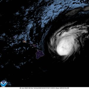
- Hurricane Douglas approaches the Hawaiian Islands (c) NOAA
Hurricane Douglas is expected to pass close to or directly over the main Hawaiian Islands from Saturday night July 25 through to Sunday night July 26. According to the National Hurricane Centre (NHC), the close passage of Douglas could bring a triple threat of hazards, including but not limited to damaging winds, flooding rainfall and dangerously high surf, especially along the east coast shores of the islands. Maximum sustained winds are near 90 mph (150 km/h) with higher gusts. Gradual weakening is expected over the next couple of days, however, Douglas is still forecast to be near hurricane strength when it passes near the islands.
Caribbean: Hurricane Hanna
https://www.nhc.noaa.gov/#Hanna
Hurricane Hanna made landfall on Padre Island, Texas on Saturday 25 July, a barrier island about 20 km (15 miles) north of Port Mansfield, Texas. The NHC said the storm had maximum sustained winds of 90 mph (150 km/h) at the time it roared ashore, but has now weakened to a tropical storm with a storm surge warning from Port Mansfield to Port Aransas.
Caribbean: Tropical Storm Gonzalo
Tropical Storm Gonzalo was forecast to move through the southern Windward Islands over the weekend, bringing heavy rain and strong winds to the islands of Trinidad and Tobago, Grenada and Barbados.
Gonzalo which started out as a strong tropical storm and was expected to become a Category 1 hurricane, had been downgraded to a weak tropical storm.
The NHC said small systems like Gonzalo were notorious for quick changes in structure and intensity, both up and down and despite its current downswing, it could re-strengthen to some degree before it reaches the southern Windward Islands.
Atlantic: Another Tropical Storm brewing
The NHC has also issued an advisory for the Atlantic where another tropical storm is brewing and has a 60 – 90 per cent chance of developing into a cyclone. Their tropical weather outlook issued at 0200 EDT on Sunday July 26, 2020 notes that a broad area of low pressure associated with a tropical wave located about 1600kms (1000 miles) west-southwest of the Cabo Verde Islands is producing a large area of cloudiness and disorganized showers and thunderstorms.
Environmental conditions appear conducive for development and a tropical depression is likely to form early this week while the wave moves westward at around 15 mph across the tropical Atlantic.
Trinidad: Hurricane Shelter
There has been a great amount of discussion in social media and via emails about the possibility of boats sheltering in Trinidad from any approaching hurricanes. The message from Trinidad, conveyed by YSATT, is that cruisers who fear they are in danger of life and limb, can seek shelter in Trinidad, but, they must be prepared to explain their decision to the Trinidad and Tobago Coast Guard (TTCG) on arrival.
Skippers that try to use protection from severe weather as a pretext to enter Trinidad should not try. All boats will be directed to anchor and be quarantined. The stated position of the TTCG is that once the danger is passed, all boats taking shelter will have to return from where they came.
Full details of the procedure to follow can be found at Trinidad Biosecurity.
……………………………………………………………………………………………………………………………………….
Related Links:
Comments