
Australia: Cyclone Jasper Forms in the Coral Sea
Australia’s first tropical cyclone of the season formed in the Coral Sea last week and after affecting areas of the Solomon Islands as a Category Two system, is expected to cross the Far North Queensland Coast on Wednesday December 13.
Published 5 months ago
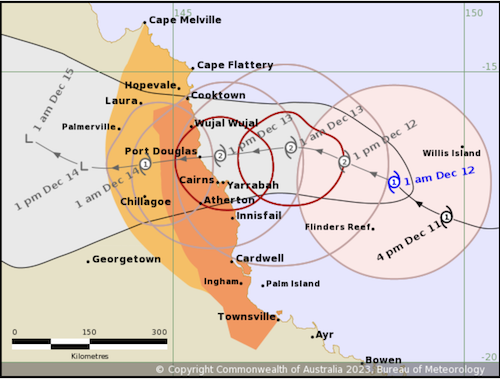
Update December 12, 2023
Residents of far north Queensland are bracing for possible power outages, internet and water supply disruptions with the arrival of Tropical Cyclone Jasper.
As of 4.30am on Monday, Jasper had weakened again to a category 1 system and was about 600km east of Cairns and 530km northeast of Townsville.
“Jasper is forecast to re-intensify during Tuesday as it approaches the coast,” Australia’s Bureau of Meteorology said.
Heavy rainfall was expected to develop along the coast from late Tuesday ahead of Jasper likely making landfall on Wednesday between Cape Flattery and Cardwell, potentially as a Category 2 system.
December 6, 2023
Cyclone Jasper is currently a Category Two system and is expected to reach Category Three, becoming severe (Category Four) from Thursday as it tracks through the Coral Sea.
As a Category Two cyclone, Jasper is currently bring gale force winds to parts of the Solomon Islands, according to the Solomon Islands Meteorological Service which has a tropical cyclone warning in force for all provinces in the country.
According to the Solomon Islands MetService (SIMS), at 2pm local time on Wednesday December 6, Jasper was 195km south-southwest of Tetepare Island in Western province and 270km west-southwest of West Guadalcanal and was expected to intensify further as it moved away from the southwest of the Solomon Islands.
Rough seas and heavy swells
“Seas will be rough with moderate to heavy swells (2.5 – 5 meters) over most waters with a potential for coastal flooding (inundation) in coastal areas. Heavy rain and thunderstorms are expected to affect most provinces,” said the MetService.
Australia’s Bureau of Meteorology (BOM) said the cyclone was forecast to become category four by Thursday evening (December 7) as the system intensified.
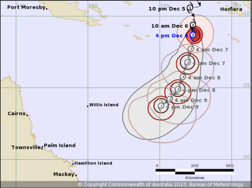
BOM meteorologist Steve Hadley said while Jasper was still quite far off Australia’s coast, in the Coral Sea, it could approach Queensland as early as the weekend and likely by early next week, bringing heavy rainfall and hurricane-force winds to the high seas, creating rough seas and swells.
Senior forecaster Laura Boekel said it was unusual to see a tropical cyclone near Queensland so early in the summer period considering an El Niño event had been declared, which brought drier conditions.
“We typically see fewer cyclones and we also see the cyclone season starting a bit later,” she said. “To see this earlier in the season and in December during an El Niño year is unusual.”
While the system remained several days away from the Queensland coast, Boekel said, the highest area of risk was the eastern coast of Queensland, north of Mackay including Cairns and Port Douglas.
.………………………………
Related News:
- Tropical Cyclone Jasper: Communities brace for power outages and disruptions (One News)
- TC Jasper Strengthens to Category Two System says Solomon Islands MetService (Radio New Zealand)
- Tropical Cyclone Jasper: Queensland Urged to Get Prepared (The Guardian)
.………………………………
Related Links:
.………………………………
Find out all news, reports, links and comments posted on Noonsite, plus cruising information from around the world, by subscribing to our FREE monthly newsletter. Go to https://www.noonsite.com/newsletter/.
Related to following destinations: Australia, Cairns, Central Province, Choiseul Province, Florida Islands (Ngella Islands), Gizo, Guadalcanal, Honiara, Liapari, Mackay, Marovo Lagoon, Munda (New Georgia Island), Noro (New Georgia Island), Outer Islands/Atolls (Solomon Islands), Port Douglas, Queensland, Russell Islands, Solomon Islands, Taro Island, Tetepare, The Whitsunday Islands, Townsville, Western Province (New Georgia)
Related to the following Cruising Resources: Hurricanes and Tropical Cyclones, Pacific Crossing, Pacific Ocean South, Pacific Ocean West, Routing, Weather
Comments