USA, Erie Canal: Transiting an Historic Waterway

Most international cruisers don’t get to do the Erie Canal in upstate New York (USA)that runs east-west between the Hudson River and Lake Erie. Regular Noonsite contributor Maryanne Webb has done it twice now and provides her thoughts and some notes on transiting this historic US waterway.
Published 2 years ago
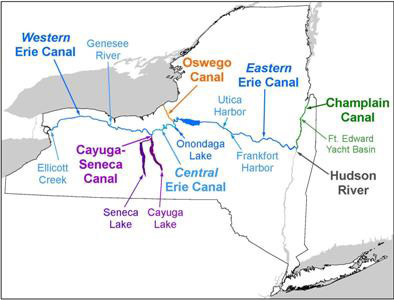
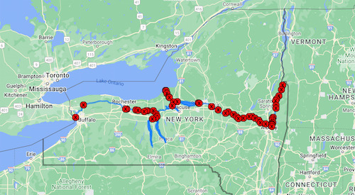
The New York Canal System links the Hudson River with Lake Champlain, Lake Ontario and Lake Erie, allowing boaters to travel from the Atlantic Ocean to the upper Great Lakes. The Canal System is part of America’s Great Loop, a 5000 to 7000 mile boating route and the shorter Triangle Loop.
General notes
The price to use the system varies by year but in 2022 it was free.
Access is seasonal – it pretty much freezes over in winter and any major maintenance also needs to be scheduled – check open dates each year, but they normally start around mid/late April .
There are several marinas on route, but also so many amazing free docks. Many (but not all) have showers, bathrooms, water, power, pump outs, some even have free laundry machines! Note for free docks there is a 48 hour limit in any calendar month.
Height restrictions mean that all sailboats need to un-step their masts, and some powerboats need to bring down some equipment.
It’s a great way to see ‘small town America’ and you can access the Great Lakes and Finger Lakes which are some great cruising grounds.
The canal system is 200 years old (in 2024) and the blue and yellow livery is very distinctive.
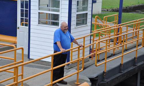
Many of the lock keepers are old timers that return each season. Each lock has it’s own flair, some with bird feeders, some with art-work, some with flower beds, etc. They are living museums and the lock keepers do maintenance in-between lockings.
In our case (this time) we chose to enter from the Hudson River, transit the whole of the Erie Canal, over-winter in the Great Lakes (on the hard) and then exit via the St Lawrence Seaway – but there are plenty of alternative options within the system.
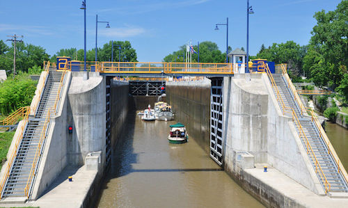
Each lock is different in lift and in quality of walls/lines. None have floating bollards to secure to. Some locks have bollards part way up the walls to help, some have wires to secure a line to, some have poles recessed into the wall (be prepared for anything)
Each lock has a couple of ladders on either side (just in case someone falls in) .
No sewage water discharge permitted. There are pump outs along the way but many are broken so call/plan ahead to be sure you catch those that are working as you need them.
The western stretch of the canal has very few locks, but does have LOTS of lift bridges (most open on demand during fixed daytime hours).
Suggestions
Amazingly the New York State Canal system doesn’t seem to publish/provide any useful guides as to the nature of each Lock and facilities at each of the towns/free docks, etc. (at least I never found one!) .
The Navionics app, with its ‘active captain’ comments, is useful to have .
Probably the best App for information on bridge, locks, etc. is ‘The Waterway Guide’. There are paying options, but you can still get map, icons and info. even without any subcriptions.
It is possible to go through single-handed (plenty do), but much easier and fun with two or three people aboard, which gives you a line handler at each end of the boat .
Consider purchasing a spare boat hook as we saw plenty that were bent and discarded along the way (ideally you need two at all times) .
Prepare your boat to dock to EITHER side of the lock (lines and fenders). Some locks only permit docking to one side (e.g. E-17 only permits locking on the south side since the turbulence is too great on the other side), and sometimes there are other issues that require you to rapidly change your plan – it is easier if fenders and lines are already prepared on both sides.
It’s good to have a hand held VHF radio (VHF13 is used by all the lock keepers) .
If you need to un-step your mast:
- be sure it is really secure and with ‘spring lines’, as the lakes can get a little rough .
- it is best stored centered on the boat (to allow docking and locking on either side) .
- consider navigation/anchor lights and radio signal while transiting.
Gloves are useful as some of the ropes can get quite muddy (or be covered in growth) .
While there seems to be no formal requirement, it is prudent to wear a life jacket ‘just in case’.
Some of the walls have large sections of missing concrete, leaving cavities in the wall. On a lift, this can cause the fender to get stuck – so be prepared to fend off the wall as you rise.
Some of the walls have old iron pins sticking out (or even the ladders may no longer be recessed) – so where possible pick your location along the wall to minimize hazards.
It is easiest (on the pulse) when you have a lock to yourself, or with just a small number of boats. When the lock is full, much more care must be taken to be sure your boat doesn’t swing out into someone else (on the other wall) .
Locking down is much more gentle than going up.
There are sufficient opportunities along the way to drop off or pick up crew, to get to supermarkets within walking distance several times a week and plenty of eating out options (ice cream, Mexican restaurants, pubs, etc.) .
Security
While some sites have video surveillance, don’t expect it. Small town America is generally ridiculously safe. The bigger the town, the less ‘secure’ you might feel. We took a detour to Syracuse and had our lines (all four) untied overnight and found ourselves adrift. There are bad actors everywhere – so if you get that ‘feeling’ be sure to secure your boat (e.g. put lines through the ‘gap’ in the dock cleat and secure both ends at the boat, so anyone would have to board the boat to untie and then you’ll most likely be roused). But don’t over worry about such things, as such instances are rare.
Plenty of trails and wildlife along the way
The route roughly parallels the I-90 (highway), and major railway lines. For much of its length there is a cycleway/trail that is busy with others enjoying the route (see Empire State Trail).
If you have space, bicycles and kayaks can get a lot of use.
Waterways are fresh water, so consider your anodes and expect to be a bit lower in the water as fresh water is less bouyant than seawater.
If you are planning to haul out or overwinter in this area, it gets way below freezing. Many places offer heated (indoor) slots, but even yard space fills quickly – so plan/book ahead.
Useful websites:
- New York State – Boating on the Canals
- Navigating the Canals – links to very detailed info by area
- Sign up for Canal Notices and Alerts: Subscribe for email notifications so you are aware of any issues or possible delays as they happen as things do break down!
- Subscribe to the USCG ‘Notice To Mariners’ for information on the areas you expect to travel
- Useful mileage chart which also shows lifts for each lock
Maryanne Webb
SV Begonia
………………………………
About the Author:
With a desire to actively “steer” their lives rather than safely continue on the conveyor belt of life, Maryanne and Kyle Webb merged their dreams and set out on a life of cruising the world more than 20 years ago. For many years their cruising was interrupted with periods based in one place to “stuff-the-kitty”, but since 2016 they have been full-time cruisers. July 2023 finds them cruising the Great Lakes on the Canada/USA border.
- SV Footprint (Begonia) Sailing Blog
- Portrait of a Cruiser – Maryanne and Kyle Webb
- For more reports from SV Begonia on Noonsite go here.
………………………………
Related Links:
- New York State – Boating on the Canals
- ‘The Waterway Guide’
- Erie Canalway – National Heritage Corridor
- America’s Great Loop
- The ICW and Great Loop (Noonsite Report)
………………………………
The opinions expressed in this article are the author’s own and do not reflect the view of Noonsite.com or World Cruising Club.
………………………………
Find out all news, reports, links and comments posted on Noonsite, plus cruising information from around the world, by subscribing to our FREE monthly newsletter. Go to https://www.noonsite.com/newsletter/.
Related to following destinations: Canada, East Coast (USA), New York, USA
Comments