Thailand, Satun: Logistics for checking in and out of this tidal port of entry

On a charter vacation from Langkawi in August 2018, this yacht charter crew chose to go through Satun for clearance into and out of Thailand. The logistics, however, were somewhat complex given that Satun is tidal and navigation marks for the approach sporadic. Some useful tips here for yachts considering using Satun for clearance.
Published 6 years ago
- The approach in to Satun by Johannes Kindt
On a charter vacation (Sun Odyssey 379) from Langkawi in August 2019, we went through Satun for clearance into and out of Thailand.
The logistics were somewhat complex given that Satun is tidal, not at all attractive to spend time there waiting for another tide in daylight, and documentation (charts, markings) of the approach is sporadic at best.
Clearing a (charter) yacht into and out of Satun on a single tide – experience report:
We chartered a sailing yacht in Kua (Langkawi, Malaysia) for 2 weeks and went to Thailand for 1 week, checking in and out through Satun.
Comments:
- For only one week, we would not do that again, given the significant effort.
- Check-in at Koh Lipe would be logistically much more favorable, but is closed in July, in the off-season.
1. Formalities- Satun, Thailand
Clearing in:
1. Immigration
2. Customs
3. Harbormaster.
All very friendly and helpful.
No fees.
Total time: ~3.5h
Clearing out:
1. Immigration
2. Harbor Master
3. Customs (Harbormaster insisted Immigration first).
Again all very friendly and professional.
Fees: Harbormaster 100THB, Customs 200THB.
Total time: 2.5h.
Note: There are no ATMs at Tammalang pier. The next ATM is apparently in the town of Satun, 15min by car. There’s a currency exchange at the pier, which was closed around noon.
2. Overall Logistics – clearing in or out of Satun on a single tide:
Starting point: Langkawi, Geopark Mangrove River
2.5h Langkawi Geopark -> Navigation point (see notes in point 3 below)
1h Navigation Point -> Tammalang Pier (critical depths)
4h Clearing in / out (4h to be reasonably safe)
1h Tammalang Pier -> Navigation point (critical depths)
4.5h Navigation point -> S or E Tarutao (depending on season)
-> 6h in critical depths (1/2 tide cycle)
-> 13h total (13.5h daylight in July)
As stated, Satun is tidal. Many shallows exist, charts/documentation are limited.
Multiple paths into Satun exist at high tide. However, as can be seen above, going in and out with a keelboat on a single (6h) high tide while making the passages in daylight would require high tide at exactly 12pm (or 2pm when returning).
We cannot recommend traveling at night here, due to a lot of floating debris (trees, ropes, nets..) as well as night fishing operations.
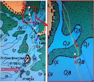
3. Approach to Satun (July 2019):
After local consultation, we did not go down the Satun River via the “Position 06° 33.97’N, 99° 57.58’E (River entrance)” stated in the “General Info” section on Noonsite.
Here a best-practice approach, after going in and out twice, which allowed us passage even at fairly low tide, providing more flexibility.
Approach is from the south, generally following the path the Langkawi-Satun ferry takes.
(Yacht with 1.5m draft, starting to go in 40min after a low tide at 1.30 on the table.)
Shallowest point not known exactly but somewhere near 2nd white marking (see below), with >>2m depth at this 1.30m tide).
Markings: Red and green buoys and white markings are permanent. Shifting shallows (no-go zones) are often marked with bamboo sticks. None of these markings are on the charts.
Navigation point: 06°27.35’N 100°03.75E, SW of Ko Yao
From here, follow the red & green buoys in (initially going E, later N and finally NNW into the river). Buoy color follows the standard (red on port going in). Look out & avoid bamboo stick areas.
At the end of these buoys, follow the 3 tall white markings going N toward the river entrance.
Leave the 1st and 3rd white marking on your Starboard when going in (to Port when going out)
Note: The 2nd marking has silted up! Going in, approx. 100 meters before the 2nd marking, turn to starboard and pass ~70m E of the marking.
~100m after passing, come back to your old line of approach. Do not short-cut to the 3rd marking. Now, continue toward the 3rd marking and into the river.
Past the last marking the river was deep (>3m) despite the (green/brown) appearance on the chart.
There are 2 more white markings in a distance further East – these are not part of the path.
Anchor in front of Tammalang Pier in the middle of the River as described elsewhere.
Immigration is in the white Terminal building, the Harbormaster in the blue building next to it. Land your dinghy next to the boat ramp left of the Harbor master’s (do not leave the ramp blocked). Tie off to the bushes.
Customs is 350m further up the river. The pier there has concrete stairs where you can tie up to a wooden pillar.
The fastest way between customs and Harbormaster/Immigration is by dinghy.
On the way out, it is helpful to follow your recorded inbound GPS track.
Side Notes:
- We were stopped by Malaysia customs when approaching the Langkawi coast coming from Satun – they reviewed our port clearance from Satun, all was in order.
- Flag etiquette in this area seemed quite relaxed, most boats don’t carry any flags. We didn’t see any “Q” flags. We did not carry a “Q” when stopped by customs – no complaints.
Johannes Kindt
Germany
……………………………………………………………………………………………………………………………..
The opinions expressed in this article are the author’s own and do not reflect the view of Noonsite.com or World Cruising Club.
Comments