Northern Marianas: Updates for 2018

Belinda and Ken sailed through the Northern Marianas in February/March 2018 and have provided entrance updates and information on the ports/anchorages/towns they visited during their stay.
Published 7 years ago, updated 6 years ago
- Pagan – North Anchorage Bay
General comments re. Entry to Commonwealth of Northern Marianas Islands (CNMI):
As of February 2018, there is no “Northern Marianas representative who can issue the necessary permit to visit the islands” in Guam; if you try to find one you will spin in circles for days.
Advice from the Port Authority and Customs in Guam was simply to check out from Apra Harbour in Guam i.e. with them, and arrive in CNMI; checking out with Immigration is not necessary. We arrived in Rota and were signed in without fuss, although they would prefer prior notice by email. We understand that the same lack of fuss would apply at Saipan as a Port of Entry, but cannot advise re. Tinian.
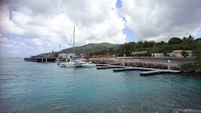
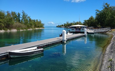
 Rota Island
Rota is a splendid, friendly Isle with “No Crime”, the locals proudly proclaim.
We used Rota as a Port of Entry from Guam, but are not sure what would apply if arriving from non-US territory. Advise the Port Authority in VHF16 or 13 when near to the harbour.
US ENC chart US5SP04M is exactly right for entry to the boat basin/floating dock area (14 08.1161 N 145 07.9708 E).
Lead markers are also correct; not sure about lead lighting, but the entry is a bit narrow to be trying at night anyway. We saw no less than 5m depth on the way in.
 We, by invitation, tied up to the floating docks but probably shouldn’t have; the docks are too light for a boat our size (46′ catamaran) and there is a fair slop coming from the entrance to bounce you around; as an alternative, you can anchor inside the basin just off the docks.
The small, struggling town of Songsong is walking distance away, from which you can get very basic supplies. The restaurant AS Pari’s provides reasonable value meals and has excellent WiFi. Not sure about the availability of mobile internet; the IT&E office was shifting, amid much confusion, when we were there. Car hire is from the Airport and they will deliver to Songsong.
 Tinian Island
Harbour entry is precisely charted on US ENC chart US5SP06M. Channel markers are in place. Call Harbour control on VHF16 or 13.
Harbour under renewal in early 2018. Docking on the main harbor wall incurs a $90 per day fee, so we were advised to tie up around the back of the main harbor at 14 57.9595 N 145 37.0655 E. Depths getting around there dipped under 3m and the area is shallow further west. Take care tying up to the wall—there is a ledge of concrete low down that might cause grief. Fender well.
The small town has the basics on offer. If you are as lucky as we were, Dimity (an Australian woman married to a local Chamorran James) will see you come in and come down to say “gidday”; she, an ex-cruiser herself, will introduce you to everything worthwhile.
Islander Car hire operates both from the town and the airport.
IT&E have an office in town that offer (in 2018) 4G SIM cards for $10 that includes $10 credit for whatever data plan you want; e.g. we took the $2.50 per day 2GB/day data plan (in March 2018) with unlimited local calls and text. The cards are good for Saipan too.
 Saipan
Entered Tanapag Harbour from Tinian, so no need for checking in other than the usual courtesy call for the use of controlled harbor space. In our case, the harbor control also allocated an anchoring area at N14 (15 13.9560 N 145 44.1060 E) after our request to dock in Smiling Cove Marina was firmly refused.
The N14 anchorage was in <10m water and had excellent, firm holding; it was subject to a continual slop that was a little uncomfortable (46′ catamaran).
The Marina does not accept “transients”, by which I think they mean liveaboard cruisers; there are cruising boats in the marina, but without residents. Smiling Cove Marina (15 13.0478 N 145 43.4282 E) readily accepts cruisers’ dinghies (free docking), but it was 1.25nm from our anchorage and slow-going through the slop; the Marina is, however, handy to the main part of Garapan Town.
There are friendly folk around the Marina; IT&E 4G mobile data at $2.50 per day for 2GB; there doesn’t appear to be any fuel dock; lots of eating places; lots of car-hire places; lots of opportunities for gambling; and if you don’t hire a pink Mustang…
Checking out (in our case for Japan) was simply a checkout from Port Control in the Port of Saipan commercial area.
Visiting the Northern Islands
We intended to call in at the Northern Islands of Pagan and Agrigan on the way up, so fortunately checked in with the Mayor’s Office (Building 1345 on Capitol Hill, 664-6471); they were very pleased to give us packages for delivery to the small communities up North.
The island communities and “Homeland Security” operate an open SSB call line on 5205.0 at 0800hrs and between 1530hrs and 1630hrs local.
Call signs are: 20Pagan for Pagan Island; 32Agrigan for Agrigan Island; 53Alamagan for Alamagan Island (from April 2018); MayorsBase for the Northern Islands Mayoral office on Saipan. I gather weather forecasts are available on request at these times with Homeland Security. Homeland Security monitors 5205.0 24hrs.
PAGAN (March 2018)
Charts of the island are varied and inaccurate, but not dangerously so.
Anchorages
There are effectively two anchorages, both at the “village” of Pagan.
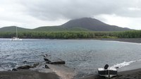
1. The easiest and the one generally recommended by the mayor and locals is an open bay at 18 07.6917 N 145 45.5330 E. There are no obstructions going in from the NW. We anchored on good holding black sand @ about 7m depth. Lots of room for many boats. A bit rolly. Probably poor in Westerly conditions (see photo at top of page).
 2. The small bay just south of the first anchorage has depth challenges according to most charts, but we were shown in on a line where the depth did not get less than 5m on the gauge. The line is 18 07.3926 N 145 45.3908 E to 18 07.3828 N 145 45.4889 E and translates to being about 30m North of the wave-washed reef on the southern mouth of the bay. Anchoring (for us) was hooking a rock, but there is firm black sand to be had in about 6m water. The bay is less rolly than the open bay. It also has regular visits by a group of dolphins.
Access
The second anchorage is closer to the “village” and is marginally easier for landing a dinghy; both beaches are steep so to get security you need to haul the dinghy high up the bank—we were fortunate to have willing hands of the village construction crew to haul up.
Looking About
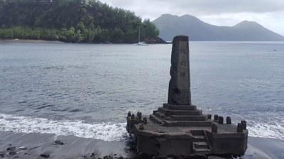
Not sure that anyone will be there when you arrive—check with the mayor’s office in Saipan. The village is near the end of a Japanese WWII airfield complete with bunkers, shrines, memorials, bomb craters and two aircraft carcasses. The airfield itself was foreshortened by a wall of lava from the eruption of 1981. But the Japanese had a much longer 20th Century history of agriculture on Pagan than just WWII; there are the remains of stout concrete villages and cisterns northwest of the airfield. Judging by the stratification of some eroded gullies in this area, the ash fall from 1981 must have been about two meters.
On the northern edge of the airfield, a perverse example of US investment is the array of solar panels, genset, battery lockers, satellite dish and control locker that apparently supplied internet to the island, although its main purpose was probably something else; supplied it, that is, until a local who had been left on the island alone for six months took to the control locker with an axe in a fit of pique. There is a heap of retrievable, valuable equipment there that the US seem to have abandoned—apparently, they were last there to do something about it seven years ago. I encouraged the locals to retrieve and recommission the Onan Genset at the very least—it has only done 200hrs—but they are terrified of Uncle Sam’s displeasure. There are wild, Brahman-like cattle about the airfield at night so be careful; I managed to spook a mob of about 30, but I guess cows with calves might be dangerous.
Quad-bike tracks heading north to the brackish lake and beyond and east on the south side of the airfield are conducive to pleasant walks. “Over the back”, by which I think the locals mean the grassy, high hills south of the airfield, is where they harvest their goat meat.
The only freshwater on the island is collected in tanks from roofs of huts in the village or old surviving cisterns in the destroyed Japanese village.
AGRIG(H)AN (March 2018)
Anchorage (18 44.3361 N 145 39.0146 E)
Off the beach about 70m in good holding black sand <8m depth. Bit rolly but the only real option on the Island. Commercial boats apparently used to load coconuts etc. from the south of the island, but we didn’t venture there.
Village
Had four, friendly male residents who were repairing the village for future resettlement: Eddie, Larry (?), CJ and another person. The village is evidently the remains of an earlier Japanese village with substantial concrete foundations.
MAUG (entry onto the Island is not allowed)
Anchorage (20 01.5187 N 145 13.8689 E)
Potentially dangerous. We eventually hooked onto something in about 10m depth and swam a stern-line to shore for security. There are the remains of a wrecked sloop nearby that, judging by the rigging, might have been ~70ft or more. Pieces of diving gear, the inflatable dinghy etc. were up on the shingle. Don’t know what it was called but it looked to be about a year in situ. We stayed for only about a four-hour breather.
Related content
Related to following destinations: Northern Marianas
Related to the following Cruising Resources: Cruising Information, Navigation
Comments