NZ: Cruising the East Coast of Remote Stewart Island
This is a report from Maryanne and Kyle Webb of SV Begonia details cruising suggestions and recommendations for yachts visiting Stewart Island, a remote island off the southern tip of New Zealand’s South Island.
Published 5 years ago, updated 2 years ago
- Oban, Stewart Island
General Information
Stewart Island is New Zealand’s third largest island, lying across the Foveraux Straight 30 kilometers from the southern tip of the South Island. It covers a 1,680 square kilometer footprint, with rugged, mountainous terrain divided by a valley separating the northern and southern ranges. An impressive 85 percent of the island lies within the Rakiura National Park, with a diverse topography that contains coastal rain forest, freshwater wetlands, vast sand dunes and granite mountain ranges, a diverse habitat sheltering a rich biodiversity of New Zealand’s native wildlife and indigenous vegetation. The island draws in hikers who travel to Stewart Island to walk the 10-12 day Northwest Circuit (125km) or the shorter 3-day Rakiura Track (36km).
Stewart Island is significantly south, so even in summer expect lots of rainy days. Given its location, we recommend visiting in the summer months to maximize better weather (December to March). Many report it is better to visit during a La Nina year as you are likely to get less rain and nicer conditions.
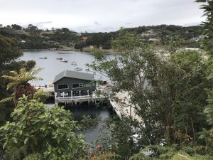
Oban
Oban is the only inhabited town and the only destination for all ferries traveling from the South Island. It has a small town center with easy walking access throughout and walking trails in the surrounding area. The town offers activities such as pubs, a museum (Rakiura Museum, NZD$2pp), and a movie theatre (Bunkhouse Cinema, NZD$10pp). You can watch artisans carve the iconic NZ stone at the local greenstone shop, and even give a hand at carving your own piece for purchase.
It is possible to view Kiwis at sunset at the rugby field on the edge of town and penguins come ashore on the coastline towards the inner southeast corner of Halfmoon Bay.
Services: Internet and cell phone coverage are available in town, though do not expect coverage in any other areas on the island. The Department of Conservation (DOC) has a lot of useful information, informative videos and a trail guide for Ulva Island (NZD$2). The Post Office also has a map and bits of local history. There are rental car services and places to rent electric bikes and other modes of transport if you want to go further inland.
Provisioning: Oban has a well-stocked Four-Square store, open 7:30am-7pm daily, with the general cost of items priced the same as what is reflected in mainland New Zealand.
Hiking: You can walk from either anchorage into Oban by road, or by following a number of trails that lead into town. We took the Golden Bay Track one way into town and alternative trails (Fuchsia Walk and Raora Walk) back to the anchorage; all are very well laid out easy to do. There is also excellent hiking on the outskirts of town, and a recommended trail is to the northeast of town off Kamahi Road which takes you to beautiful swimming beach. Kaka birds have a mind of their own and may or may not be in town, but if you hit the trails you have a good chance of seeing at least one.
Food: Recommend South Sea Hotel, a pub-restaurant located on the waterfront (acts as a cafe at lunch) and Kai Kart on Ayr Street (an excellent fish & chip shop and classic Kiwi cuisine, open at lunch and evenings). Otherwise, wander down Main Road and visit a host of other cafes in town.
Basic Hut Accommodation
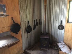
- Kellys Hunting Hut, Port Adventure
There are two options when looking to spend a few nights ashore in the national parks. One option is DOC huts, run by the department of conservation which usually includes minimal amenities for a nominal cost. This other recommended option are the Hunters Huts, similar to DOC huts, but run separately by hunting groups. If there are no current visitors you can normally find a rough trail to follow, though we suggest you leave a note if you visit in the guestbook. If there are hunters at the hut, however, be sure to make contact before you start wandering around the grounds as they are hunting deer and you would not want to be mistaken for one! We found all the hunter’s huts were marked on our map app (we use Pocket Earth Pro) so they were easy to find; they should also be marked on any topographical map. It is worth knowing in advance where the hunting and DOC huts are (Note: Oban offers a host of other hotel and hostel options).
Fees
A NZD$5/per person fee is required for those visiting Stewart Island. If you arrive by ferry or plane this is included in the transport cost. There is an honesty box at the wharf, or you can pay your fees at the library.
Weather and Radio Services
There are no NowCast Stations covering all of Stewart Island area, but CH 20 is used for Bluff and surrounding areas and you may receive that signal (particularly if you are north of Stewart Island).
• Puysegur Maritime Radio is VHF 16, VHF 67
• Stewart Island Maritime Radio is VHF 16, VHF 71
• Bluff Maritime Radio is VHF 16, VHF 68
VHF coverage is not always great so if you can get email via radio or satellite phone you can also get weather reports by emailing: [email protected] with any subject line. In the message text enter: send https://www.radionz.co.nz/news/weather/coastal and you will get a reply with the text of that web page which includes a current and 3-day forecast for all NZ coastal regions. (Note: This is a workaround since the URLs for the met service don’t return the actual weather part of the web page).
Download: New Zealand Maritime Weather Region Map
Hiking
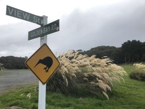
- Kiwi Crossing, Oban, Stewart Island
Many of the anchorages outside of Oban have no obvious trail markings so it is worth having a map if you hope to explore many of the trails. It is worth picking up a map that details the tracks or download an app that shows topographical detail. We use PocketEarth Pro app with pre-downloaded offline maps.
Mobile and Online Services
Oban is the only place on Stewart Island that has any cell phone coverage and service is provided by all NZ mobile service providers. Do not expect any signal outside of town (beyond about 3.5 miles).
Southern Lights
At 47°south, Stewart Island is a great place to see the Aurora Australis, with the best months being March to September. With clear skies and no light pollution, your chances of seeing the lights with a KP above 5 are high. If you have internet access, you can go direct to the website for updates: Aurora Forecast
For radio and email updates, you may send a query with the following detail for an update:
- Send request to [email protected] with any subject line and in the message text enter a line with the text send http://www.aurora-service.net/aurora-forecast/. You will get a reply with the text of that web page which includes current and 3-day forecast for KP Index forecast in UTC times (Note: email must be formatted specifically, so follow above in detail).
Orientation and Anchorages
The Cruising areas on Stewart Island are (clockwise from the NE):
Horseshoe Bay (often confused with Halfmoon Bay given the shape of the inlet). No known anchorages and the bay is relatively exposed.
Paterson Inlet (this is a huge inlet with numerous anchorage options at the northeast corner of Stewart). There are two main anchorages for yachts to anchor, Halfmoon Bay and Golden Bay, both close in distance but involves heading through Paterson Inlet to get from one to the other.
• Halfmoon Bay. This is where all ferries arrive from the mainland and it is the main harbor for the island. Some moorings exist (possibly all private) and anchoring is available.
• Golden Bay. This bay lies to the south of Oban in Paterson Inlet, however it is not the best anchorage as the holding is not secure and there is only room outside the morning field for one boat. Moorings are available, though we cannot advise how to secure one. The anchorage is also the drop-off and pick-up point for water taxis to Ulva Island (NZD$25/pp) and the wake situation can be very uncomfortable. It is a short walk into Oban town center. The dock attendant says not to leave boats unattended, but we were told by a local we could leave our boat on the end (not the sides). Be sure to tie to the floating bits and not the fixed posts as there is a tide. Golden Bay (located to the South of Oban town).
• Prices Inlet. On the west side of Paterson Inlet, with an old whaling station with only a few foundations remaining: a slipway, an old boiler and several big propellers which had been swapped out when they were damaged by Antarctic ice (recommended).
Ulva Island, Sydney Cove (the place to anchor if you are not taking the water taxi from Golden Bay). Ulva Island is a tiny island off Oban to the south (within Paterson Inlet) and is considered part of Stewart Island. Ulva is a nature sanctuary with old growth forest, and most of the island is inaccessible with all the trails located on one end of the island (all trails take less than two hours to complete).
Kiwis (a native New Zealand bird, typically active at night) are resident on the island and, with luck, may be seen during the daytime. The birdlife, in general, is most active at mid-morning when the temperatures warm up, so time yourself accordingly. Conservation of the native species is taken seriously and it is critical that this is maintained – you are expected to adhere to strict biosecurity regulations. Going ashore at night is prohibited, and wardens and volunteers are based on the island to ensure regulations are adhered to. We recommend that you purchase the guidebook in town (NZD$2).
Port Adventure (the most western point on the island). Despite the name, this is a harbor rather than a port.
• Oyster Cove (located on the western side of Port Adventure). The narrow cove is just wide enough to allow a boat to swing on a single anchor and offers perfect protection from the winds outside. Recommend taking your dingy to Kelly’s beach take a hike that starts at the hut. There are other anchorages but we did not visit them.
Port Pegasus (Again, a harbor not a port; off the tourist track). This harbor has some of the most dramatic scenery and a visit is highly advised, with “Bald Cone” and other rock formations of note. There are plenty of anchorages available in the southeast corner of the island, and Sylvan Cove to the western corner.
West Coast of Stewart Island. The west coast gets very fewer visitors and we cannot advise as we did not visit. Anchorages are available but exposed; detail can be found in the Mana Cruising Guide.
Guides and Resources
New Zealand Marine Radio Handbook by John Allen (2009) has been recommended though may have dated information. More up-to-date information appears in the Beneath the Reflections guide.
Stewart Island Cruising Guide, Mana Cruising Club 1996. Useful if planning to spend time exploring Stewart Island.
Otago Trailer Yacht Squadron offers local guides (https://www.sporty.co.nz/OTYS/Cruising-1/Cruising-Guides); an excellent section of anchorages for Patersons Inlet. It includes reports from two separate cruises: one report from 1981 and another (in the same document, towards the end) from 1989/1990.
Area Tourist Guides such as Lonely Planet and free regional brochures (provided at AA, iSite Visitor Centers) are useful.
NZ Fishing Rules Application is useful and up to date (and are available online).
Sailing to Fiordland and Stewart Island: What you need for a successful circumnavigation of New Zealand (2012).
Jim and Katie Thomsen of S.V. Tenaya provides excellent information from cruisers, offering useful tips and an excellent list of local charts. Information is available at S.V. Tenaya
Maryanne and Kyle Webb
SV Begonia
The opinions expressed in this article are the author’s own and do not reflect the view of Noonsite.com or World Cruising Club.
Related to following destinations: New Zealand, Off-lying Islands (New Zealand), Stewart Island
Related to the following Cruising Resources: Off the Beaten Path
Comments
-
May 3, 2019 at 1:50 AMkia says:
