
Lessons Learned from Providing Shore-Support during the 2020 west-to-east Atlantic crossing

A useful report by Alex Blackwell, OCC Regional Rear Commodore, on lessons learnt from providing shore-support for over 200 cruising yachts during the 2020 west-to-east Atlantic Crossing.
Published 5 years ago
![]() The onset of the COVID-19 pandemic in March 2020 created unprecedented chaos for coastal and ocean cruisers worldwide.
The onset of the COVID-19 pandemic in March 2020 created unprecedented chaos for coastal and ocean cruisers worldwide.
Read Retreat from Paradise by Daria Blackwell, which details how the Ocean Cruising Club responded to support the cruising community as a whole (not just their own members).
Amongst other efforts, the OCC implemented a safety net for yachts crossing the Atlantic, which proved invaluable. It is an honourable tradition of the sea to render every assistance to those in distress or requiring help, and both members and non-members did indeed need help. For several months it became a full-time job, with significant overtime to boot.
We were able to assist with numerous urgent and distress situations, and also provided weather routing suggestions to several yachts which requested it as well as to yachts receiving assistance.
The weather routing was made possible by PredictWind, who provided us with professional-level access to their weather forecasting and routing. Cooperation was also established with Coast Guard Regional Control Centres (RCCs) on both sides of the Atlantic and in the Azores. We reported incidents as they arose and requested their help when situations deteriorated. They also contacted us for assistance and feedback on specific incidents once they learned that we were indeed in earnest.
The following is a synopsis which may assist skippers planning their own passages or future shore-support teams watching out for their friends on a crossing.
Record keeping:
Similar to the need to maintain a logbook on a yacht, the recording of information quickly became an integral and very time-consuming task when keeping track of literally hundreds of yachts crossing the Atlantic. Multiple task-specific Excel spreadsheets were set up for this and, where appropriate, shared with the team via the ‘cloud’.
Float plan:
Perhaps one of the most important aspects was listing participating yachts. In essence this became a tabulated float plan which helped team members contact individual yachts if it became necessary.
Filing a float plan neither diminishes the accomplishment of making an offshore passage nor can it be seen as hand-holding the skipper and crew, but rather is just there should something go awry. In addition to suggesting that boats crossing should provide their information for the boat list, we also recommended a proper float plan be submitted if not already done so elsewhere.
The US Coast Guard, for example, will not accept float plans, but they do provide a very useful template for one. It is important that yachts undertaking a passage provide this information to a trusted person ashore in case something should happen.
There was one incident where a singlehander got into difficulties. The person holding the yacht’s information contacted the UK and US MRCC and relayed the communications from the yacht. The MRCC contacted us for assistance, relaying the information. As this was not a distress situation they then needed to stand down, but were unable to pass on the contact information due to data protection regulations. A very frustrating week passed before the person with the information contacted the OCC and direct communications could be established with the yacht. We were then able to relay the re-escalating urgency of the yacht’s situation back to the MRCC in the US and later in the Azores Rescue Co-ordination Centre. Two commercial ships and a Portuguese naval vessel were diverted by the respective RCCs to assist the skipper. Had a float plan been lodged, this whole process would have been greatly simplified.
Position Tracking:
When boats that we were assisting for one reason or another were not on the PredictWind tracker, we plotted their reported positions on Google Earth. We recorded their track and calculated their bearing and speed, precisely the information the RCCs needed for their own logs.
Communication Logs:
When we realised that much of the communication with yachts was via SMS satellite communications and that no record of these was retrievable from the providers, logs (Excel spreadsheets) were initiated of outgoing and incoming messages. A positive side-effect of this was that the character length of the message could be calculated automatically – a limiting factor with text messaging, with each technology having its own peculiarities.
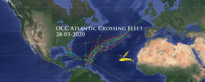
PredictWind:
In addition to their weather forecasting services, PredictWind provided a fleet tracker for our fleet at no cost, organised by Tim Goodyear. PredictWind had just developed the tracker and we effectively became the beta-testers. Inclusion in this was recommended for all yachts with Iridium Go!, Garmin inReach, YellowBrick Tracker or using a Sat Phone with e-mail.
PredictWind provided wind forecasting and a tracking map that showed the location of participating vessels in the passage to Europe. Participants had free access to upload positions and were able to view the positions of other boats on the PredictWind Offshore App, which could be installed on Windows, Mac laptops, or on IOS or Android. Each vessel’s personal page could be shared with friends and relations and also included a very useful blog feature. We posted a detailed instruction sheet on Facebook, adapted from those published by the Salty Dawg Rally.
The information needed by PredictWind to get a yacht set up on their tracker as part of the fleet was collected by our team and added to an online spreadsheet. The PredictWind support staff had access to this spreadsheet and drew what they needed from it. The team then co-ordinated with individual yachts to ensure they were up and running.
Communication Resources:
Whereas satellite voice communications are generally one-to-one, we remain proponents of the one-to-many option of HF/SSB radio. Having said that, satellite communications have evolved and by using e-mail and data a vessel may indeed transmit a message to many (pre-selected) recipients at once. Examples of this are sending an SMS text or e-mail message to more than one recipient or uploading a message to a blog, social media or other interface. Either way multiple people can be alerted to a ‘situation’.
In our opinion, satellite communications are essential on board an ocean-going vessel these days.
The communications systems that the team had to deal with were wide ranging, each with its own quirks. We will leave out VHF, which is generally of little use mid ocean – with the exception of one relay where the distressed yacht only had VHF and one of ‘our’ fleet happened to be listening and was able to relay. Daria has addressed the HF radio nets [see Retreat from Paradise] that we had in the Atlantic, so that too is omitted here.
- Alex and Daria Blackwell
When it comes to satellite communications, we worked with:
- Iridium phone – allows voice and data communications, the latter including e-mail and SMS. PredictWind position updates were done manually via e-mail.
- Iridium Go! – communications options are via voice, e-mail and/or SMS, depending on the subscription package. SMS to the Iridium Go! is via a specific Iridium web page form. There is a 160-character limit, which includes the sender’s e-mail address. PredictWind position updates are via a built-in tracking feature and can be at intervals or when sent manually. Iridium Go! also allows data downloads. PredictWind and other weather routing resources are thus relatively easily accessible.
- Garmin inReach – communications are via SMS. Outgoing messages from the yacht are forwarded to an input e-mail address, while messages to the yacht are sent through a recipient-specific Garmin web page form. There is a 160-character limit, which does not include the e-mail address. Garmin inReach provides its own tracking page but can also be interfaced with the PredictWind tracker.
- YellowBrick – can include SMS messaging, though to send messages to a YellowBrick device a special app is required. YellowBrick provides its own tracking page but can also be interfaced with the PredictWind tracker.
- SPOT – Of all the Sat Comms equipment we worked with, only SPOT is on the Globalstar network which provides poor to non-existent coverage mid Atlantic. Communications are SMS sent to and from e-mail. There is a 140-character limit which includes the sender’s email address. SPOT uploads positions to its own tracker, which gives a good visual but with little information other than a position.
The bottom line when it comes to satellite communications is best stated in the old adage that ‘You get what you pay for’.
Alex Blackwell
OCC Regional Rear Commodore
- Read the full report with images in the OCC E-Zine.
- Ocean Cruising Club Website.
…………………………………………………………………………………………………………………………………..
The opinions expressed in this article are the author’s own and do not reflect the view of Noonsite.com or World Cruising Club.
Related to the following Cruising Resources: Atlantic, Atlantic Crossing, Circumnavigation, Communications, Communications Equipment, Cruising Information, Cruising Networks, Cruising Radio Nets, Indian Ocean, Pacific Crossing, Position Reporting, Red Sea, Routing, Safety, Safety and Medical
Comments
