Family cruising Suwarrow, Samoa, and Tonga

A family of four record their experience sailing the central South Pacific from July through September 2018.
Published 7 years ago, updated 6 years ago
Experience Report September 2018 – SV Moya
Summary
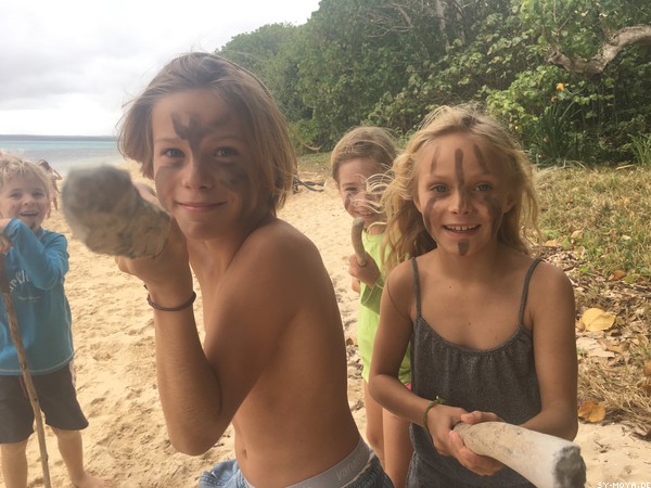
We, a family of four, sailed the central south pacific, some cruisers are referring to as the dangerous middle, during July, August and September 2018. Weather during this period was sometimes challenging but was no shortcoming of our amazing adventures in Suwarrow (Cook Islands), American Samoa, Samoa and Tonga. We enjoyed the beauty of the Pacific, the rich cultural heritage and the truly welcoming and open-hearted nature of its people. Herein, we report our trip highlights, our experiences on land and sea as well as local mooring and service facilities.
 Our highlights:
• Enjoying the remoteness of the uninhabited, un-spoilt atoll Suwarrow
• Experiencing foreign cultures at the Samoan cultural village in Apia
• Feeling the heat at a traditional fire show in Apia
• Submerging in the glowing, aquamarine the Ocean trenches in Upolu
• Finding the roots of Dr Jeykl & Mr Hide in the Villa Vailima in Apia
• Meeting giant humpback whales in Tongas waters
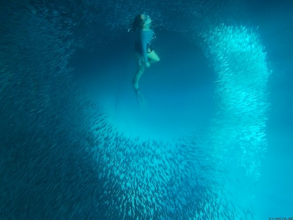
• Swimming with millions of fish in Vavau’s Swallows Cave
• Listening to breathtaking singing at church service in Samoa or Tonga
• Free Diving in the glowing Mariners Cave
Weather of the dangerous middle
The weather in the central south pacific is highly dependent on from west to east moving high-pressure systems at around 30 degrees south. Respective highs are responsible for the southeasterly or easterly trade winds. In between the high-pressure systems, troughs occur regularly. These troughs often bring unsettled weather and a change in wind direction even sometimes resulting in a full wind conversion to westerly directions. When we have been sailing through this region we have continuously been looking for acceptable weather windows with winds from the E or SE and avoided through coming troughs were possible. Nowhere on our trip from Europe to the central Pacific, GRIB files have been as false as between the Society Islands and Tonga. On many occasions, forecasts, even for the near future, did not reflect reality. Weather charts (e.g. streamline analysis and forecast for the Pacific from the NOAA) indicating weather patterns in a wider context have been more helpful to navigate in this area. By studying respective charts we could see the location of the south pacific convergence zone, locations of highs and lows and upcoming troughs to be avoided. Predictions of the movement of these weather systems were surprisingly accurate, even though wind speeds and directions in GRIB files were not. Moreover, we downloaded the weekly newsletter from Metbob every Sunday, which nicely explained the weather for the upcoming week and provided recommendations for passage making. We still got stuck in a few annoying but never dangerous situations by using described measures in addition to weather information via GRIB files.
SUWARROW
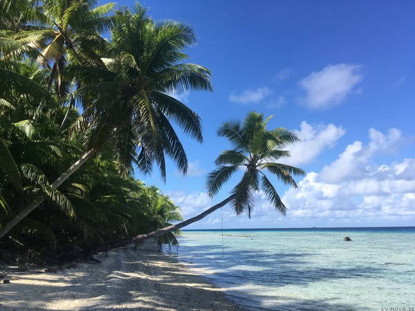
Suwarrow has been one of the most remote, fascinating places of our sailing trip so far. The beauty of the islands and reefs are absolutely stunning.
Safety
Suwarrow is uninhabited except for a ranger and his assistant during the season. Apart from rangers and fellow cruisers we encountered no humans, but instead fish, crabs, rays and sharks. Inside the lagoon, we saw only black-tip and white-tip reef sharks, but outside larger types are present.
Formalities
Rangers file all required paperwork for inbound clearance to the Cook islands on board of the yacht. Arrival should be annotated in advance via a certain form, which we missed to do, but were allowed to enter the country without. Next to customs and immigration, questionnaires covering board supplies have to be filled in for the rangers to assess health and quarantine risks. We have been asked that fresh produce need to stay aboard and were informed about the national park rules. Finally, we paid the national park fees in USD (50 USD).
Outbound clearance was performed in the ranger shelter on the day prior departure.
Navigation
Suwarrow is a true atoll, which we entered through the pass. It is not advisable to enter in the lagoon during the night as the path is not lit. During the day two sticks mark the shallow parts of the pass. The timing of tides is not required, the lagoon can be entered at all tides without strong currents. Navionics charts reflect the pass accurately.
Mooring
As Suwarrow is a national park it is only allowed to anchor in front of the main island. It is not permitted to visit any of the other islets. We anchored in front of the dingy dock in 6 meters over sand between a number of bommies. The anchorage is well protected from easterly and northerly winds and swell. Holding is good.
Services
None. Suwarrow is a very special place. Rangers bring their own supplies for the whole season and are living in their shelter.
The passage from Suwarrow to American Samoa
With a favourable weather forecast (continues easterly winds at 15-20 kts) for the next 7 days, we left Suwarrow for Vavau, Tonga. After a nice first sailing day, winds calmed down to 10 knots and completely died on the fourth day at sea. Until the expected trough and the associated westerly winds some days later, winds were not forecast to pick up again. As we did not want to motor the remaining passage and experience unstable weather, we changed our plans and headed to Pago Pago. We motored for 22 hrs to finally reach American Samoa in the morning.
AMERICAN SAMOA
Safety
Samoan people are most welcoming. We did not feel unsafe at any time.
Formalities
When entering Pago Pago it is required to contact the port captain at VHF ch 16. We have been advised to tie up to the main wharf prior to a mooring or tying up at the yachts club. The main wharf is located between the container terminal and McDonald’s. It is not designed for yachts but rather for large fishing vessels or freighters. We tied up next to one of the huge bumpers and were supported by a few workers ashore. After tying up and completing the customs paperwork a customs officer boarded Moya and thoroughly looked for drugs including narcotics and weapons. At the main wharf, we additionally were required to fill in forms for quarantine and health. Thereafter, the captain was sent to the immigration office (located approximately 1 km in the direction of town) to complete our inbound clearance (fees 40 USD).
For outbound clearance, we have been asked to visit the port captain and customs. The customs officer prepared our clearance papers after customs fees have been paid (100 USD).
American Samoa – Pago Pago
Navigation
The approach to Pago Pago is buoyed and lit, this can be done also at night. Possible hazards are marked.
Mooring
We anchored in the inner harbour at position 14°16.53′ S, 170°41.44′ W in 8 meters relatively close to shore. Holding in the harbour is not great and gets poorer in the middle of the bay. A recent tsunami destroyed major parts of the island and dragged lots of movable parts into the bay. We did not pull anything up with our anchor but heard from other cruisers that it is quite common. Even at moderate winds, we saw a few boats dragging across the bay.
During our visit, we did not see any moorings. However, it is possible to tie up to the yacht club pontoons located on the southern side of the bay. Berthing needs to be requested by the port captain.
Services
Wifi can best be obtained by a local data SIM card or by signing up to one of the Hotspots. We purchased a weekly data package from one of the Hotspots, 5 GB were at 10 USD and the connection was great, not what you expect from home but probably best we had in the south pacific.
Public transport 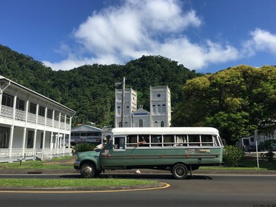 works very well on the island. Local buses go back and forth to town and to other parts of the island every 10 or so minutes, they do not have a certain schedule. One ride was 1.50 USD per person. The central bus station is located just beside the farmers market.
Provisioning is great in American Samoa, but you need to take the bus into town, except for local fresh produce, which can be obtained at the farmers market. But you can also get imported vegetables like kiwi, peaches and grapes in one of the warehouse-style supermarkets in town. We shopped at Cost-U-Less and have been offered a free ride back to Pago Pago harbour. Cost-U-Less is supplied once a week directly from the US and offers a variety of American branded products you cannot get anywhere else on the south pacific islands. Next, to the supermarkets, there are several specialised shops in town selling e.g. shoes, hardware, etc.
Laundry can be done at many different places, the closest one to the harbour is likely a large Chinese shop on the western end of the bay. 1 load washing was 1 USD, drying 1.25 USD.
The passage from American Samoa to Samoa
We sailed the approximately 80nm overnight at moderate winds from the south and little swell. Until we moved into the lee of Upolu it was a quick sail, we arrived around noon in Apia.
SAMOA
We only did a short stopover in Samoa as the weather did not allow to go straight to Tonga, but were positively surprised by the beauty of the island Upolu, the rich cultural heritage and the kindness of the people. Samoa was one of the highlights of our whole trip.
Safety
Safety in Samoa was very good. Despite the people being poor, we never felt unsafe or experienced any unfortunate event.
Formalities
Samoa is asking for inbound clearance of boats prior to tying up or going ashore. We contacted port control on VHF Ch 16 already from outside the harbour but could connect to port control only upon entry to the inner harbour. Port control asked us to anchor in the bay and wait for customs to come on board, before tying up in the marina. As we prepared the yacht for anchoring, the customs lady on board of a moored superyacht (too large for the marina) waved and advised us to tie up in the marina. We checked with port control again, who kept telling us to go at anchor in the bay. As the officials could not get aligned, finally we decided to go to the marina. We were asked to stay on board until customs and health visited us on board. After doing the paperwork, we received clearance to go ashore and visit immigration in town (2nd level of the grey skyscraper on the other side of the bay, next to the tourist office) and have been told quarantine would also visit us on board within the next days, but they never did. We visited immigration first the next morning as the office was closed (opening hrs 8am-4pm) after completion of customs and health clearance.
For outbound clearance, we visited customs and immigration again and have been asked to pay our port fees (approx. 20 USD)
Samoa – Apia
Navigation
Navigation to Apia appears straight forward, but actually, a pass through the coral reef needs to be transited. The marina lies on the east side of the inner harbour. Mooring
As a small yacht (smaller 60 feet) we were asked to tie up in the marina. The small marina has basic facilities and is locked during the night. A marina bar is located nearby. Marina fees for 5 days were approx. 100 USD.
 On Land
In town, there are several restaurants. We recommend the marina bar, as well as Paddles only a few minutes from the marina.
On Tuesday nights, the ice cream bar, just across the street from the marina offers dinner (local food) and a fire show, both we highly recommend.
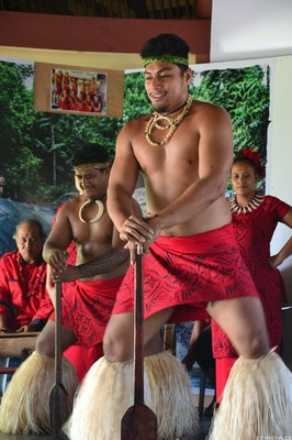
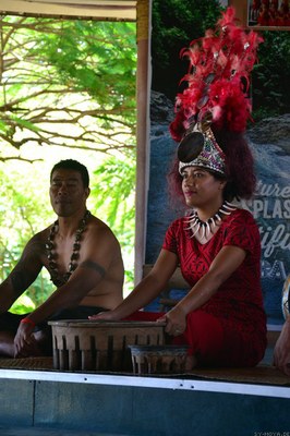
Four days a week the tourist office hosts a cultural village show (Tue-Fr, starting at 10 am). The show has no admission fee, but we have been asked for a donation at the end. The show was excellent, starting with weaving of little baskets and covering a kava ceremony, traditional dancing, preparation and tasting of traditional food (laplap), traditional tattooing, wood carving and traditional cloth making from bark of mulberry trees. Close to the bus station there is a very nice playground for kids We visited the war monuments close to the former yacht club, but there was not much to see.
On Sundays going to serve is a must.
Up the hill lies Villa Vailima, previous home of Robert Louis Stevenson (RLS), who authored books such as Treasure Island and Dr Jeykl and Mr Hide. We joined a guided tour (12 USD/person) through the house and learned about the special relationship of RLS to the locals and the historic Apia as it was occupied by the Germans. We also hiked up the hill to RLS grave and enjoyed excellent views over Apia and the bay.
There are at least five waterfalls around the island to visit. We only visited the falls at Totgitogiga (good for swimming and jumping) and Papapapaitai (large waterfall, lookout only), both free of charge. We did not go to the waterfall slides in Apia, as our children were too young for the slide.
On the southern side of the island, the ocean trench is spectacular. It is a very deep, blue glowing water hole connected to the ocean (admission fee approx. 9 USD/person). A dip within is quite refreshing. Within the same park, one can also visit the blowing holes (only at high tide) and has very nice views along the southern side of the island.
Approximately 30 car minutes east of Apia, the cave pools are located close to the beach. To visit the freshwater pools, we drove through a Christian college and were asked for an admission fee (4 USD/person). In the cave pool, we snorkelled the silver and gold glimmering freshwater fish.
On the southeastern end of the island, supposedly beautiful white sandy beaches are located, which we did not visit for lack of time.
Services
Wifi could be obtained from the Marina bar or by purchasing a local data SIM card. Digicel with 1 GB credit valid for 1 week was approx. 7 USD. We got our card at the Chinese store at the road crossing, 2 min walking distance from the marina towards town.
Provisioning in Apia works well. Apart from various Chinese stores, Apia also has a number of supermarkets, Farmer Joes are one of the better ones. The supermarkets do not offer American brands but a selection of products from New Zealand and Australia. Fresh produce can be best obtained at the farmers market in town.
Apia also has a few specialised stores e.g. computers, copy shops, office supplies, fishing supplies, hardware stores.
Just across the street from the marina, a car rental is located. We rented the smallest class car for one day (approx. 80 USD), but time was not sufficient to explore the whole island.
TONGA
Tonga, especially Vavau, is a great and convenient destination for cruising. The islands are used to cruisers and next to the breathtaking nature offer many cruiser friendly facilities. It was the perfect place to catch up with (family) boats we previously met on our way from Panama through the Pacific and saying „see you later“ before heading north whereas everyone else went south.
Safety & Formalities
Safety is Tonga is very good, people are very welcoming, supportive and generous. We never felt unsafe and also did not hear of any unpleasant occasion or incidence from other cruisers.
For inbound clearance please refer to the clearance section of Niuatoputapu, for outbound clearance to the clearance section of Neiafu.
The passage from Samoa to Niuatoputapu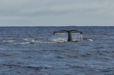
Sailing from Samoa to Tonga is not always possible as one needs to go almost dead south. We have been looking for a suitable weather window, already when we entered American Samoa. After approximately two weeks the forecast predicted 48 hrs light to moderate easterly winds, which were not sufficient to go straight to Vavau, but OK to reach Niuatoputapu. In reality, winds were much lighter as predicted (below 5 kts), thus we spent the first-day motor sailing and drifting until the breeze picked up a bit.
Tonga – Niuatoputapu
Navigation
Niuatoputapu has to be entered via a pass on the northern side of the island. The pass is buoyed, however, buoys are rusty and colours are hard to recognise. Entry during the day is advisable. As we entered the lagoon we did not experience strong currents even though we did not time slack water, but came in at mid tide.
Mooring
We anchored close to the main wharf at 15°56.51′ S / 173°46.03′ W in 8 meters over sand. The anchorage was well protected from southerly swells, but only little from prevailing south and southeasterly winds. Holding was good, though.
Clearance
Tonga requires the approval of mooring from customs prior to dropping the anchor or tying up. We tried to radio customs on VHF ch 16, but could not connect. As we arrived Saturday in the afternoon, we did not go ashore on Sunday and again tried to make contact on Monday morning via VHF without any success. Thereafter, we went ashore, asking our way to customs (located next to the TD Bank, halfway between the main wharf and the village Hihifo), where we have been told that officials will come on board in the afternoon. At the bank it was possible to change USD to local currency, there is no ATM. In the afternoon we picked up two officials, the lady was representing customs and immigration, the man quarantine and health. They did all paperwork for inbound clearance on board within 1-2 hrs. Imported fresh produce was required to stay on board. We have been asked to pay clearance fees (135 Tonga dollars) cash in local currency.
 On Land
There are several hikes around the island, including visiting the village of Hihifo and walking across the island to the very nice beach on the southern side of the island. It is also possible to walk the rim, but we didn’t do this as the mosquitos already have been very aggressive on our shorter walks.
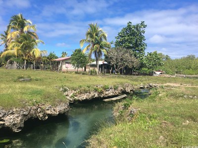
At Hihifo we visited the freshwater springs and took a refreshing dip. The village is country style with many pigs and chickens running around. It might be possible to organise a tour to the neighbouring island if gasoline can be supplied to the locals. No whale watching tours are offered, but we spotted many whales from the anchorage and when we left the island.
Services
Next, to the Tonga development bank (TDB), there is a small shop on the island selling basic supplies and one shop selling TCC SIM cards. In May 2018 the island was connected to the TCC wifi network, thus internet now is accessible via data sim card. The passage from Niuatoputapu to Vavau.
After spending 4 days in Niuatoputapu we became restless and took the first opportunity to head for Vava’U. ESE to easterly winds at 15 knots had been forecast for the next 48 hrs, which should have given us OK conditions to reach Vavau. After we left Niuatoputapu and motored around the easterly corner, we set sail and just managed to hold for Vavau. Within the next 2 hrs, the wind shifted to the SSE and picked up in strength. We ended up tacking against 25 gusting 30 knots of wind and accompanied swells during the first night. Conditions the next day have been a bit more favourable as winds shifted to the SE and decreased to 20 kts, further south the weather further calmed down. We gladly reached Vavau early on day 3 and were looking forward to a quiet anchorage and to some sleep after the rather unpleasant days.
Tonga – Vavau
Vavau is a group of beautiful islands, some of them are surrounded by coral reefs. The islands are lying close together, thus distances are short when travelling through the archipelago. As waters are generally very deep, there are only around 40 anchorages annotated by numbers for reference. We only describe anchorages we have been visiting during our stay, others might be equally nice or even nicer.
Anchorage 1 – Neiafu
Navigation
Navigation into Neiafu is straight forward during the day. The channel is partially buoyed but not lit, thus entry during daytime should be preferred. Waters from the western entrance through Fairava passage until the village are generally deep and mostly free of hazards.
Clearance
If entering Tonga from a foreign country, it is required to contact customs on VHF Ch16 before anchoring or tying up. Usually, they ask you to tie up to the main wharf to do the inbound clearance. Despite the completion of our inbound clearance to Tonga in Niuatoputapu, we still contacted customs on VHF Ch16. As we arrived on Saturday evening, the office was already closed. Instead, the central station from Nuku´alofa was covering the radio, who informed us to directly tie up to a mooring ball and complete the domestic clearance on the following Monday.
For outbound clearance, it is required to either tie up to the main wharf or anchor directly in front of it. Immigration will stamp the passports and international clearance can be received upon paying the port fees (approx. 6 USD) at the port captain located in the same building. Duty-free fuel can be requested from a fuel truck at the day of outbound clearance.
Communication
Radioing in throughout Vavau is being possible via a repeater on VHF Ch21. The repeater is accessible in a good quality throughout the entire island group, thus it is frequently used. Communication on this channel should be short and precise or refer to an alternative (not repeated) channel. Every morning Monday to Sunday 8:30 am (local time) a cruisers net takes place on VHF Ch21. Local businesses moderate the net and inform about news, the weather, events, and much more.
Mooring
It is possible to tie up to the main wharf for customs or to receive fuel. Anchoring in front of the wharf or in shallow waters in front of the small boat marina is an alternative. Most yachts, however, tie up to one of the mooring balls rented by the local dive shop. They are marked with a number as well as VHF Ch09. As the dive shop is not always listening to the radio it is acceptable to first tie up to one of the moorings and inform them later which buoy is taken (7 USD/night). The anchorage is very well sheltered from the swell of any direction, we also experienced good protection against winds blowing from several directions.
On Land
There are several restaurants in town. We tried the Hideaway fish and chips, located on a small blue houseboat moored in front of the dive shop. The owner Barry makes delicious fish and chips, rather expensive though. The Mango restaurant next to the dive shop is one of the few businesses opened 7 days a week and sells a large variety of different kinds of food, burger, pizza, fish, meats and also local dishes. The Tropicana Cafe sells coffee, tea and cake and also offers many yacht services.
On Sundays going to church is a real event, almost everybody is going in their best traditional outfits. The singing is breathtaking.
Many people are signing up for a whale tour to swim with the whales, which must be a unique experience. We, unfortunately, did not join one of the tours for budget reasons (approx. 240 USD/person).
Services
Internet: TCC SIM cards for mobile devices and credits can be obtained in the village (SIM card plus 3GB valid for one month is about 20 USD). Alternatively, access the Wifi of Mango cafe.
Provisioning: Next to the small boat marina farmers are selling fresh produce from Monday to Saturday. Selection is quite good, especially when coming early. There are several small, mostly Chinese owned, shops in town offering basic supplies, frozen meats and few dairy products. Selection in every shop is a bit different. Close to the church (blue house), the Deli is offering very nice homemade sausages, different kinds of meats (everything frozen) and passage food (upon request).
Gas: Tropicana Cafe offers to refill propane bottles (approx. 2.50 USD/kg) several times a week. Alternatively, one can directly refill the bottles at the local gas station outside town.
Yacht services: There is a small chandlery in town, offering a very limited selection of items, but maybe a good contact to get spares shipped. Tropicana Cafe sells courtesy flags and movies per GB.
Laundry: Tropicana Cafe offers laundry services, most of the time with the same day turn around (approx 4 USD per load washing & drying).
Rubbish: Rubbish can be disposed of next to the small boat marina (approx 1 USD/bag).
Anchorage 7 – Port Maurelle
Navigation
Port Maurelle is lying just behind the corner to the western entrance of the island group. It is a deep bay lined with white sandy beaches. The entry we experienced free of hazards.
Mooring
It is possible to anchor close to the beach or alternatively take one of the moorings (4 USD/night). The bay is well protected against swells from N – E – S.
On Land
Ideal anchorage to explore Swallows Cave by dingy and Mariners Cave either by dingy or by a yacht in case several people join on one boat and take turns diving in the cave. It is not possible to anchor in front of the Caves as water levels are too deep. There is also no possibility to tie up the yacht or the dingy, so one has to stay on board all time. Snorkelling in Swallows Cave is extraordinary, especially in the afternoon, when the sun shines in the Cave. Millions of small fish swim in the cave to interact with and watch them building always new formations. It is possible to swim or dingy in the cave. The entrance to Mariners Cave in approximately 2 to 3 meters below the water surface, thus it is only possible to free dive into the cave. Inside is no natural light source, except the light entering through water in the entrance. The entrance from within appears glowing blue.
Services
None. Internet via TCC SIM card.
Anchorage 11 – Tapana
Navigation
Entry to Tapana anchorage is straight forward during the day. It is only possible to access the lagoon from the western side, either via the passage between Afo island and Tapana island or to the north of Afo island. We went through the southern passage between Afo and Tapana without any difficulties.
Mooring
The lagoon is very protected from winds and swells of any direction. When we entered Tapana, outside the lagoon southeasterly winds were blowing with 25 knots, whereas inside barely any breeze she was noticeable. There are mooring balls available at approx. 7 USD per night. The ones closer to shore have been not maintained lately, but the ones in deeper water looked well with strong ropes. It is also possible to anchor in more shallow waters at the eastern side of the lagoon, as we took one of the moorings we cannot comment about holding.
On Land
Just behind the mooring balls, it is possible to beach the dingy at a very small beach. From there a path is starting, leading to a graveyard and even further across the island (the hike is not for arachnophobic people, as many quite big spiders are building their nets in the trees above and across the path).
On Tapana island on the west side of the lagoon, a little beach is located with a Spanish Tapas restaurant (main courses at approx. 40 USD).
Services
None. Internet via TCC SIM card.
Anchorage 13/14 – Hunga/Blue Lagoon
Navigation
The only way to access the Hunga lagoon is from outside the Vavau archipelago. There is a narrow entrance between the rocks located at 18°41.71′ S / 174°08.17′ W. In the middle of the entrance a small rock is lying, which need to be passed on its south side. We (draft 1.9m) entered the lagoon close to low tide, but it is advisable to enter no sooner as mid tide as the bar on the inside behind the pass is quite shallow. We had 30 cm of water below keel on the shallowest bit. Once the bar is passed, water levels are dropping quickly.
Mooring
Mooring balls are located on the western side of the lagoon (owned by Berry) as well as on the southern side of the lagoon, close to the entrance to the blue lagoon (owned by Analulu). We attached to one of the balls at the south side of the lagoon (10 USD/night). Our mooring spot was well protected from winds and swells from southerly directions.
On Land
There is a small hiking trail to the Blue Lagoon. At high tide it also possible to dingy over to the blue lagoon. We visited Analulu from Trans-Ocean Tonga on the far western side of Fofoa island. As we dingied through the lagoon we have seen several rolling yachts at anchor inside the blue lagoon. There might be more things to do on the western side of the lagoon, but we did not explore.
Services
None at the south side of the lagoon, we cannot comment about the western side. Internet via TCC sim card.
Anchorage 30 – Kenutu
Navigation
Kenutu should be only approached during the day in good visibility. Coming around from Neiafu, we approached Kenutu through the Fanua Tapu pass lying south of Tapana. The pass used to be buoyed, but it was not when we made the trip in August 2018. Even though we entered the pass with a rising tide close to high tide, it was at several locations shallow and eyeball navigation was key. Once through the Fanua Tapu pass water level drops, but the last bit into the anchorage is also shallow and has quite a number of bommies to be avoided.
Mooring
We anchored close to the beach at 18°41.93′ S / 173°55.77′ W. Anchorage is quite open to winds from southerly directions but largely protected from swells.
On Land
There is a beautiful white sandy beach ashore. Snorkelling around the anchorage is quite nice. Also one can do small hikes on the reef, to the outer reef and to the cliffs on the other side of Kenutu island.
Services
None. Internet via TCC Sim card.
Article by SY Moya.
Related content
Portrait of a Cruiser: German crew Christian, Sabrina, Joshua and Jonathan of Yacht Moya
Related to following destinations: American Samoa, Apia (Upolu), Cook Islands, Neiafu (Vava'u), Niuatoputapu Island, Pago Pago, Samoa, Tonga
Related to the following Cruising Resources: Circumnavigation, Cruising with Children
Comments