

South Pacific Cyclone Season 2022: Up to 10 Cyclones Predicted
The South Pacific Cyclone Season officially began on November 1st. This year forecasters are predicting up to ten (10) named Tropical Cyclones (TCs) could occur in the Southwest Pacific, while Australia could experience an above average number of cyclones.
Published 1 year ago
Significant Differences between West and East
For the coming season, New Zealand’s National Institute of Water and Atmospheric Research (NIWA) along with the country’s MetService is expecting significant differences between the western and eastern halves of the Southwest Pacific basin.
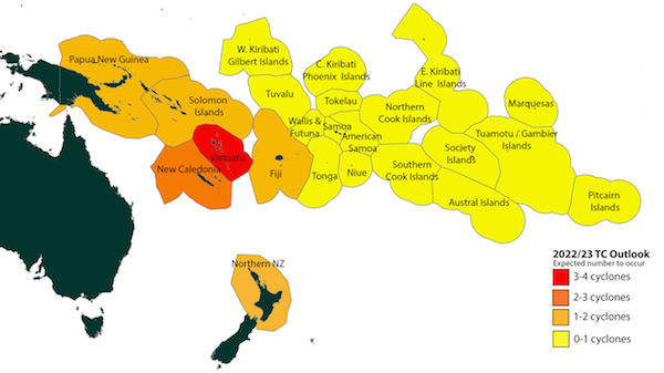
Elevated TC activity is expected in and around the Coral Sea and the north/central Tasman Sea during the full season from November – April. The risk of impacts from a TC are expected to be higher across that maritime region and around Vanuatu. Reduced TC activity is expected east of the International Date Line.
Vanuatu and New Caledonia typically experience the greatest TC activity, with an average of about two or three named TCs passing close to those island nations each year. For this season, elevated TC activity is expected for areas around the Coral Sea and Vanuatu. Normal or elevated activity is expected for New Caledonia and Papua New Guinea.
The Solomon Islands and Austral Islands are expected to have normal TC activity. Near normal or below normal TC activity is expected for Fiji, Tuvalu, and the southern Cook Islands.
Below normal TC activity is forecast for Tuvalu and most other islands near or to the east of the International Date Line including Wallis & Futuna, Samoa, American Samoa, Tokelau, Tonga, Niue, the northern Cook Islands, the Society Islands and the remainder of French Polynesia. Despite the risk reduction in some locations, TCs are still expected for countries that typically experience one or more named storms per year. At least three severe TCs reaching Category 3 or higher might occur anywhere across the region, so all communities should remain prepared.
- Tropical Cyclones predicted by NZ’s NIWA
Fiji Weather Office Predicting up to Seven Cyclones
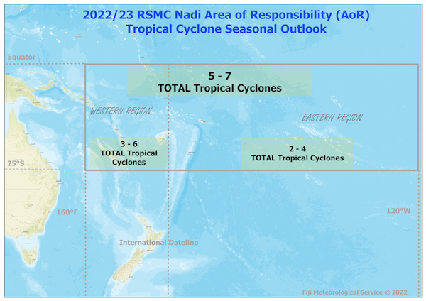
In its Tropical Cyclone Outlook for 2022/2023, Fiji’s Meteorological Service (FMS) said that in total, five to seven named tropical cyclones were expected between now and April 2023.
In their TC Outlook, FMS said that on average, around seven Tropical Cyclones affect the Regional Specialized Meteorological Centre – Nadi’s (RSMC-Nadi) Area of Responsibility (AoR) per season. Thus, this season is predicted to have an average or below average number of TCs.
On average, around four TCs affect west of Dateline and around three affect east of Dateline per season. Tropical cyclone numbers to the west of Dateline in the RSMC-Nadi TCC AoR is likely to be three to six or average to above average TC activities, while numbers to the east is likely to be two to four TCs or average this season.
For severe TCs (Category 3 or above), average or below average severe TCs are anticipated this season, with one to four severe TCs expected. On average, around three severe TCs affect the RSMC Nadi-TCC AoR per season.
This seasons TC outlook is greatly driven by the return of a third consecutive La Nina event, which is quiet exceptional and the event is likely to persist until end of the 2022.
- Image from Fiji Met Service.
More Tropical Cyclones for Australia
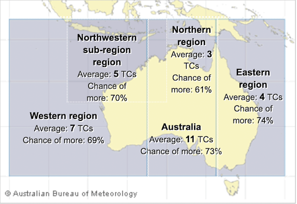
Australia’s Bureau of Metereology (BOM) is forecasting an above-average number of tropical cyclones for the 2022–23. Since Australian records began in 1969–70, the average number of tropical cyclones that form in a season in the region is 11, four of which typically cross the coast.
The established La Niña in the tropical Pacific Ocean and warmer-than-average sea surface temperatures to the north of Australia, have influenced this year’s tropical cyclone outlook according to the BOM.
In La Niña years, the first cyclone to make landfall on the Australian coast typically occurs earlier than normal, around the middle of December. During average years, the date of the first tropical cyclone to make landfall over Australia is typically in early January. At least one tropical cyclone has crossed the Australian coastline in every season since reliable records began in the 1970s.
Outlook influences
The BOM’s outlook is based on the status of the El Niño–Southern Oscillation (ENSO) over the preceding July to September. La Niña was fully established in the tropical Pacific in September 2022, the third La Niña in successive years. Climate models suggest ENSO will return to neutral conditions in early 2023.
Ocean temperatures to the north of the country, especially in the Coral Sea are currently warmer than average. Climate models predict warmer than average waters are likely to persist to the north of Australia for the coming 3 months, marginally increasing the likelihood of tropical cyclones developing.
Tropical cyclone activity in the Australian region has large variability from year to year, due to the influence of naturally occurring climate drivers, such as ENSO. The number of tropical cyclones in the Australian region is generally higher with La Niña. In recent decades, the annual number of tropical cyclones that form in the Australian Region has decreased, from an average of 11 across all seasons since Australian records began in 1969–70, to 9 for the period since 2000–01.
- Percentage change of more tropical cyclones than average (c) BOM
………………………………………………………………………………………………………………………………………
Related News:
Fiji Met Service – Tropical Cyclone Outlook 2022/2023
NIWA – South West Pacific Tropical Cyclone Outlook 2022/2023
BOM – Australian Tropical Cyclone Outlook 2022/2023
BOM – Tropical Season Outlook for the Coral Sea 2022/2023
………………………………………………………………………………………………………………………………………
Noonsite has not independently verified this information.
Related to following destinations: Australia, Cook Islands, Fiji, Nauru, New Caledonia, New Zealand, Niue, Norfolk Island, Papua New Guinea, Samoa, Solomon Islands, Tokelau, Tonga, Tuvalu, Vanuatu, Wallis and Futuna
Related to the following Cruising Resources: Hurricanes and Tropical Cyclones, Weather
Comments