
St. Martin to Colombia: Single-Hander Activated PLB – Alert for All Vessels in the Vicinity

All vessels in the vicinity of the Caribbean Coast of Panama, Costa Rica, Nicaragua are requested to keep a sharp lookout for the trimaran S/V TRINAVIS, which may be overturned and barely visible or wrecked. Help spread the information about Italian captain Rocco Acocella’s disappearance. Initial alert from the SSCA HF Radio Service KPK with updated comprehensive drift analysis by Chris Parker of the Marine Weather Center and subsequent updates from the International Boat Watch Network and “Rocco Acocella Missing” official facebook page.
Published 6 years ago
Update August 29, 2019 – from Panama Cruisers Facebook Page:
The Colombian authorities, who are coordinating the SAR of Rocco Acocella, say that the passive search is still taking place.
The area of Rocco’s land search mainly focuses in Colombia, Panama and on the islands in that area.
The area of Puerto Escondido appears as one of the most likely areas of impact in Colombia, due to the stream that goes from Panama to North-East.
Many different channels are active in the search on land, we, the family, are supported by many experts, each one of them is consulted for his expertise.
We still need everyone’s help for sharing the pictures of Rocco and of the Trinavis and for spreading the information about his disappearance, in the said places.
We also ask you to help us with the contacts that you believe that might be helpful.
Your ideas and your advice are always more than welcome.
Thank you very much to all of you.
Update July 22, 2019
From the official source of verified information about the search and rescue of Rocco Acocella.
The coasts of the three states (Panama, Costa Rica, Nicaragua) are still to be considered plausible areas for the search.
After considering the prevalent winds, we can hypothesize that Panama and Costa Rica are the main areas of interest.
These coasts are mainly uninhabited areas, where there are wide woods, which make the search more difficult.
We ask for everyone’s help (churches, radio broadcasts, word of mouth, etc.) to help us spread the information about Rocco Acocella’s disappearance, in the little fishing villages and in the little communities, which are harder to reach through internet or telephonically.
We also ask for maximum diffusion at sea so to help us get in touch with whoever might have seen the wreckage of the Trinavis.
Update July 18, 2019
From International Boat Watch Network
The authorities in charge have inspected the islands in front of Nicaragua and the tract of the Colombian sea.
They are still searching for Rocco Acocella with maritime means and via radar.
SHARING is important.
MAXIMUM ALERT on land too.
New Drift Analysis of S/V TRINIVIS
By Chris Parker, Marine Weather Center 06 JULY 2019
Posted July 7, 2019
Hello Cruisers,
There has been a lot of erroneous information regarding the PLB activation belonging to the trimaran TRINIVIS. The following is information believed to be as accurate as possible regarding when the EPIRB was activated, and when the battery ran out some 54 hours later. It had previously been reported the PLB only transmitted for 24 hours.
Initial EPIRB activation: 6/22/19 at 1936 hrs UTC. Position 13 17.4 N / 071 48.4 W.
Final ping before battery died: 6/25/19 at 0147 hrs UTC. Position 12 05.0 N / 072 43.0 W.
As a favor to the Seven Seas Cruising Association (ssca.org) High Frequency Radio Service KPK, Chris Parker of the Marine Weather Center (https://www.mwxc.com/) has taken that data and conducted a comprehensive drift analysis which is presented below:
Based on the following drift analysis, cruisers in the areas which Chris Parker suggests the vessel may currently be on 06 JULY 2019, please keep a sharp lookout for the S/V TRINIVIS and report any sightings to any Search & Rescue authority.
Very Respectfully,
Glenn Tuttle – Net Manager
SSCA HF Radio Service KPK
KPK@ssca.org
941-456-5070
Comprehensive drift analysis – Chris Parker
During 54 hours of EPIRB transmissions the vessel moved 89 miles, on course 217T, for a speed of 1.7k.
Current, based on the present HYCOM forecast (assuming currents were similar 14 days ago) would have set the vessel due W (270T) about 1.5k, as long as he was N of about 13N….
but S of 13N in areas W of 72W or 72-30W, currents off Colombia drop to close to zero, and in areas W of 73W there may even be some counter-current flowing to the N (or a bit NW or NE, but under 0.5k).
Winds would have averaged about 080T-090T in the area near EPIRB activation.
Wind strength by the way on Tue 22 of June was probably nominally 30g40k, and could easily have hit 35g45k periodically. So, yes, there were strong winds at the time.
But focusing on directions…near the area of EPIRB activation, both the current and wind would have pushed the vessel on a 260T to 270T course….yet his course for 54 hours was 217T.
This suggests to me he was able to manage his course some.
For the 88 miles traveled in 54 hours, about half of it (the 1st half) was in a W-flowing current averaging 1.5k…and the other half was with much less current.
In order to achieve a Course Over Ground of 217T with a W-setting current and wind, the vessel would have been pointed pretty much S, toward Colombia, which would make perfect sense if he was actively managing his drift and trying to get to landfall along Colombia.
On June 24-June 25 wind fell lighter, generally under 20k, with daytime winds even lighter.
June 26 onward was very strong, with nocturnal winds 35-40k sustained, gusting to 50k.
These winds are generally NE-E in direction (varying in a diurnal pattern, with strong winds veering from NE to E late afternoons-nights / lighter winds backing from E to NE mornings into afternoons), so winds average ENE, and would blow the vessel on a course of about 240T.
If the vessel was able to continue actively managing his direction of drift, then I think he could have made landfall somewhere along Colombia. A course of 217T would intersect the Colombian Coast near 11-20N / 73-15W (55 miles from his last EPIRB transmission on June 25 morning).
Even assuming he drifted farther W, the Cape at Santa Marta (11-20N / 74W) is 88 miles, bearing 241T from his last EPIRB transmission on June 25 morning.
If, without the W-setting current, his Course Over Ground was more Southerly, then he might have intersected the Coast somewhere E of 73-15W.
I would focus efforts along the Coast of Colombia between 73W to 74W Longitude (give-or-take a bit).
—
Chris Parker
Weather Forecasting & Vessel Routing
Weather & Communications – Hardware, Software, Sales, Consulting, Books,
Seminars
www.mwxc.com
Marine Weather & Communications LLC (and dba Marine Weather Center)
5130 Medulla Rd
Lakeland FL 33811
ph 863-248-2702
fax 863-248-4666
First News Item – Posted July 6, 2019
BOLO for S/V TRINAVIS
The SSCA HF Radio Service KPK has confirmed with multiple Rescue Coordination Centers, the Personal Locator Beacon (PLB) registered to the S/V TRINAVIS was activated on 22 June, 2019 at position 13 15.6 N / 071 51.3 W.
This position is consistent with 19 NM NW of the 800 NM Rhumb Line between St Martin and Barranquilla, Colombia. It has now been confirmed the PLB Beacon was in fact transmitted from the S/V TRINAVIS.
The PLB was an Ocean Signal PLB1, touted as the world’s smallest PLB.
S/V TRINAVIS left St. Martin on 17 June and the PLB was activated on 22 June and ceased operation approximately 24 hours on 23 June.
The EPIRB activation was received by Curacao RCC, and relayed to the Colombian Navy. A search and rescue attempt was initiated by air and sea by the Colombian air and navy with negative results.
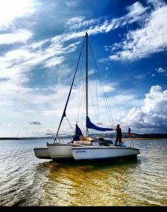
The trimaran TRINAVIS (a Telstar MKII, 8 meters long) would probably float, even if turned turtle. It is very possible the captain, ROCCO ACOCELLA is still very much alive and in his dinghy or clinging to the overturned trimaran.
All vessels in the vicinity of the La Guaria Peninsula of Colombia is requested to keep a sharp lookout for the S/V TRINAVIS, which may be overturned and barely visible. The Captain, ROCCO ACOELLA, is a very seasoned transatlantic cruiser, and very fit person. He may very well be alive in his dinghy, or clinging to the pontoon of his vessel.
Please spread this message far and wide. This cruiser may be clinging onto life and needs help. We hope the Colombian Navy will re-active their search for him. His beacon broadcasting for 24 hours before the PLB battery dying was a huge problem to his rescue. But we hope the Colombian Navy will re-initiate their search, keeping in mind the drift of the sailboat in that proximity.
We can only offer our prayers and best wishes to Rocco for a safe recovery.
Glenn Tuttle – Net Manager
Seven Seas Cruising Association
High Frequency Radio Service KPK
KPK @ssca.org
941-456-5070
Related to the following Cruising Resources: Safety and Medical


Good day,
I’m a little confused here. An epirb supposedly sends it’s gps position. The boat was close to the coast. How come that over more than 2 days nothing was found at the gps position of the epirb?
Philippe