
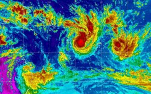
South Pacific: Two separate cyclones developing

Two separate cyclones are developing in the Pacific, both threatening to impact several countries later this week, with Fiji in particular being warned to be alert.
Published 5 years ago

- From Fiji Met.
Cyclones Yasa and Zaza were both named by authorities on Monday, the first in the South Pacific for this summer’s cyclone season.
Yasa has developed into a category two storm in the waters between Fiji and Vanuatu.
Fiji – Cyclone Yasa:
RSMC Nadi Warning as of 02:12 UTC, December 14, 2020:
- TROPICAL CYCLONE YASA CENTRE 985HPA CATEGORY 2 WAS LOCATED NEAR 15.8 SOUTH 171.7 EAST AT 140000 UTC. POSITION POOR.
- REPEAT POSITION 15.8S 171.7E at 140000 UTC. CYCLONE MOVING NORTHWEST AT 4 KNOTS.
- CYCLONE INTENSIFYING. EXPECT SUSTAINED WINDS OF 50 KNOTS CLOSE TO THE CENTRE INCREASING TO 55 KNOTS BY 141200 UTC.
- FORECAST POSITION NEAR 15.2S 171.2E AT 141200 UTC AND NEAR 14.7S 171.9E AT 150000 UTC.
Port Denarau Marina report that overall the basic philosophy of the warning for TC Yasa remains unchanged.
At 6pm this morning the centre of Category 2 TC Yasa was located about 630 km to the west-northwest of Viwa island in the Yasawa group. This is slightly further away from Fiji than it was this morning, and is explained by the fact that the cyclone centre is at its most distant from Fiji as it completes a clockwise loop over open waters to the west-northwest.
The most recent forecasts this evening for TC Yasa contain two significant modifications from those overnight and in the early hours of today. First of all, the cyclone may move closer to Viti Levu than first expected. Secondly the forecast intensity as it makes its closest approach to Fiji is now category 4. This makes it an extremely powerful cyclone.
The most recent forecast from the US National Weather Service has the centre passing within 200 km of the southern Mamanucas around noon Friday on its closest approach to Fiji. The US navy forecast is of more concern. It has the centre making landfall very near to Nadi town around the same time.
It will be another 24 to 36 hours before the cyclone completes its loop, and only then will the path taking the cyclone in the general direction of Fiji be known with any precision.
It is recommended that due to the high level of uncertainty yacht skippers be prudent and plan on the worst case scenario. Vessels that can, should consider moving to the east of the group. Others should consider seeking refuge in creeks and mangrove stands as per procedures established by the relevant authorities and managed by the local Marina.
Extended periods of heavy rain are expected over all of Viti Levu and all of Vanua Levu, and about Lomaiviti, Kadavu and nearby smaller islands. Flash flooding and river flooding is very likely going to affect transport corridors on land, close airports, and close coastal shipping. This is especially problematic over the western division, with heavy rain commencing late Wednesday and continuing until Friday potential to bring flooding to the significant rivers in the west.
Tonga – Cyclone Zazu:
Cyclone Zazu – a category one storm – is now unleashing heavy rain on northern Tonga near the Vava’u islands, where gale force winds have already been recorded. Zazu is expected to keep strengthening as it moves southeast to possibly a category two cyclone from early Wednesday. Its current track will take it to the northeast of Tonga’s lower islands, and to the southwest of Niue.
The monsoon is becoming very active and there are signs in the extended range outlooks of other disturbances which may form between now and Christmas in the south-west Pacific, some of which may develop further.
……………………………………………………………………………………………………………………………………….
Further Reading:
- Dual cyclones threaten to menace several Pacific countries (RNZ)
- https://www.denaraumarina.com/category/news/
……………………………………………………………………………………………………………………………………….
Noonsite has not independently verified this information.
Related to following destinations: Fiji, French Polynesia, Niue, Tonga, Vanuatu
Related to the following Cruising Resources: Hurricanes and Tropical Cyclones, Weather


YASA expected to make landfall between the two main islands of Viti Levu and Vanua Levu tonight. Follow the storm at https://www.facebook.com/FijianGovernment/.
Port Denarau marina report today:
YASA CONTINUES TO INTENSIFY EVEN MORE , WITH WINDS NOW UP TO 120 KNOTS, A SOLID CATEGORY 5 TROPICAL CYCLONE IN OUR SCALE HERE IN THE SOUTH PACIFIC. EXTREME THREAT FOR FIJI IS INCREASING AS TC YASA COULD BECOME ONE OF THE STRONGEST TROPICAL CYCLONES EVER OBSERVED IN OUR BASIN.
Good news item at: https://www.stuff.co.nz/world/south-pacific/123721795/cyclone-yasa-fiji-prepares-for-damaging-winds-flooding-as-category-5-storm-heads-for-centre-of-island-group