Update September 09, 2019 – by Martin Jutzeler:
Pumice raft now around Fiji and Lau Islands. The raft stayed for several days around Lakeba Island, and is still partly stranded on it. Most of the raft is now dispersed into multiple clusters made of < 1 x 3 km ribbons. The raft is drifting westwards (280 degrees) at ca. 20km/day and its direction should not change over the next 5 days. Pumice can be found over a very wide extent in the Lau Islands but should not be of major concern.
Update August 28, 2019 – from Martin Jutzeler via French Polynesia Cruisers Facebook Group:
The eastern islands of Fiji (Moce & Oneata) are going to be hit in ca. 3 days if the wind continues as forecasted. I expect some lone pumice to be stranded over Moce and in particular Oneata over the next 1-2 days already.
Update August 25, 2019 – from Martin Jutzeler via Jon Wright of SY Itchy Foot
Hazard map of the drifting pumice raft between Tonga and Fiji
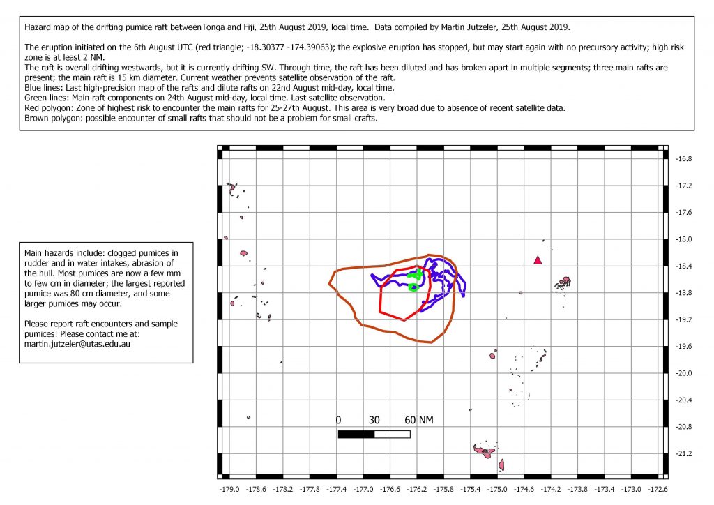
The eruption initiated on the 6th August UTC (red triangle); the explosive eruption has stopped, but may start again with no precursory activity; high-risk zone is at least 2NM.
The raft is overall drifting westwards but is currently drifting SW. Through time, the raft has been diluted and has broken apart in multiple segments; three main rafts are present; the main raft is 15km diameter. Current weather prevents satellite observations of the raft.
Blue lines: Last high-precision map of the rafts and dilute rafts on 22nd August, mid-day, local time.
Red polygon: Zone of highest risk to encounter the main rafts for 25th to 27th August. This area is very broad due to the absence of recent satellite data.
Brown polygon: Possible area in which you may encounter small rafts that should not be a problem for small craft.
Reported August 20, 2019:
Shannon Lenz and Tom Whitehead on board SV Finely Finished reported to Noonsite that they encountered the slick of pumice on August 9, 2019 when they were about nine hours out of Vava’u on passage to Fiji.
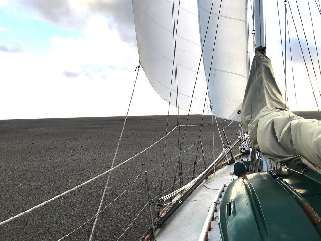
- SV Finely Finished sailing through a “raft of pumice”, August 9, 2019
Gulf Harbour Radio in New Zealand also confirmed the presence of the pumice field to Noonsite, providing information from Michael and Larissa Hoult onboard the catamaran Roam who encountered the slick on August 15, 2019, also on their way to Fiji.
A “raft of pumice”
Reporting the pumice field to Noonsite, Shannon of SV Finely Finished said they first encountered intermittent streaks of small pumice and rocks at about 14.30. An hour later pumice and rocks in large patches appeared when they were at position 18° 24.049’ S 174° 39.765’ W.
“We were motor sailing at the time we hit the patch, so quickly shut down the engine,” said Shannon. “The pumice plugged up the head but we were able to flush it out. At about 16:30 we were sailing through a thick mat of pumice approximately 15 centimeters thick which completely covered the ocean to the horizon.
“Our position at this point was 18° 22.068’ S 174° 50.800’ W.
“I don’t know the exact time we exited the field but sometime around 22:00 on a heading of 290°.”
View this video footage of the pumice slick from Tom and Shannon.
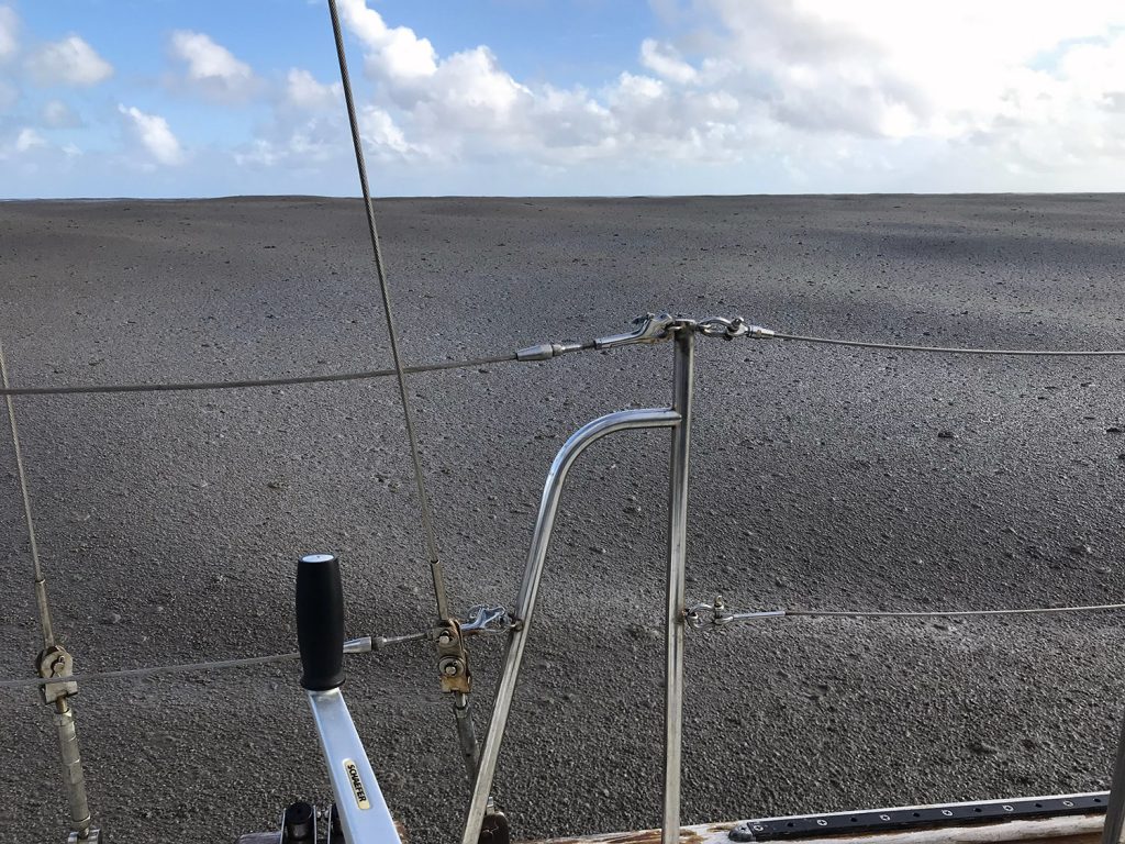
- Pumice as far as the eye can see from SV Finely Finished
Floating rocks and the smell of sulfur
Michael and Larissa Hoult on the catamaran Roam reported to Gulf Harbour Radio in New Zealand that they encountered the slick on August 15, 2019, noting that it covered the surface to such an extent that water was not visible.
“We had heard the previous day on email of “pumice fields” 50NM north of Vava’u,” Michael reported. “We saw none as we rounded north of Vava’u earlier in the day on our route from Bora Bora. Sailing on 255T we started seeing some floating rocks of random sizes (marbles to tennis balls) from position 18 46′ S 174 55’W, so we reduced sail to slow our speed.
“At position 18 50′ S 175 05′ W we had a faint but distinct smell of sulfur. TWD = 115T at the time had us down wind of Home Reef which is charted as an area of volcanic activity. We continued sailing at reduced speed on 250T. At position 18 54’S 175 19’W we started to see and strike larger floating rocks. We took down all sail and allowed the boat to continue on bare poles at 2-3kts on COG 255T. As we could no longer smell the sulfur we assumed we would be soon clear of the rubble so elected to continue at slowest speed. “
Surrounded by pumice of all shapes and sizes
“At approx 07:00 UTC (19:00 local) 15/8/19 at position 18 55′ S 175 21′ W we entered a total rock rubble slick made up of pumice stones from marble to basketball size. The waves were knocked back to almost calm and the boat was slowed to 1kt. The rubble slick went as far as we could see in the moonlight and with our spotlight. We made a turn to starboard and managed to sail clear of the rubble slick under staysail.”
Michael said the slick was extensive in all other directions and their steering became temporarily and partially fouled by rocks jamming between rudders and hull.
“Once clear of the rubble we acted with caution and retraced our course under 3rd reef main and staysail before turning south and then west,” he said. “We contacted other vessels in the immediate area and remained in touch to update one another on our status and the conditions in area.
“Our intention was to return to the east and sail around the windward side of Home Reef and surrounding charted areas of volcanic activity some 35NM to our SE. The two other yachts we informed of the rubble slick found clear water going south and turning west from 19 00′ S 175 05′ W so we followed them. We have since cleared all sign of volcanic rock and
are continuing to Fiji.”
Pumice excites vulcanologists
The pumice field has also excited vulcanologists from the University of Tasmania in Australia. Via RCC New Zealand and Gulf Harbour Radio in New Zealand, Dr. Martin Jutzeler of the University has asked for co-operation from cruisers that encounter this current, floating pumice field in the form of data, photos and samples.
Dr. Jutzeler’s request:
1. Sightings (although I would enjoy having data from within the large rafts, I do not recommend boating through them, especially not with engines on).
- Lat/Long
- Length/width of the raft
- Thickness
- Photos
- Are the pumices touching each other?
- What is the range in pumice size? (e.g. peas, coconut, or metric system)
- Is the surface of the pumice rough or rounded?
- Is there life growth on them already?
Send the sightings data and photos to:
martin.jutzeler@utas.edu.au
2. Samples:
- If crews cannot send the samples, they can simply take photos in front of an even background. Close-ups are important as well.
- All sizes
- All shapes
- Any interesting pumice, but don’t forget to sample the most common ones.
- Sample set labeled with location and raft size/thickness
- Pumices should be individually wrapped in toilet paper so they do not crush
- Send to me in a cardboard box with mention of: Rock with NO SOIL-NO PEST
Send samples to the following address:
Dr. Martin Jutzeler
Lecturer in Earth Sciences & Honours coordinator
Earth Sciences & CODES | School of Natural Sciences
University of Tasmania
Private Bag 79
Hobart TAS 7001
Australia
T: +61 3 6226 2406
Related Reading: