Pacific Weather: NOAA Announces Gridded Forecasts now Operational

NOAA’s National Hurricane Centre (NHC) has announced that offshore and high seas gridded forecasts for the Pacific Basin have gone from experimental to operational.
Published 4 years ago

This major forecasting milestone for mariners took place on October 28, 2021. ![]() The forecasts originate from the Tropical Analysis and Forecast Branch (TAFB) of the National Hurricane Center (NHC), the Weather Forecast Office (WFO) in Honolulu, Hawaii, and the Ocean Prediction Center (OPC).
The forecasts originate from the Tropical Analysis and Forecast Branch (TAFB) of the National Hurricane Center (NHC), the Weather Forecast Office (WFO) in Honolulu, Hawaii, and the Ocean Prediction Center (OPC).
There are five elements making the transition:
- 10-meter (33-feet) wind speed;
- 10-meter wind direction;
- 10-meter wind gusts;
- significant wave heights (or “seas”); and
- marine hazards.
Transitioning these forecasts to operational status is another milestone for the
NWS National Digital Forecast Database (NDFD) and follows a similar move in December
2017 with the Atlantic offshore grids.
Users do not need to take any action when the experimental forecasts transition to operational status. An example of the wind and wave grids from NHC/TAFB are shown below for a forecast valid at 1200 GMT Tuesday, October 26th, 2021:
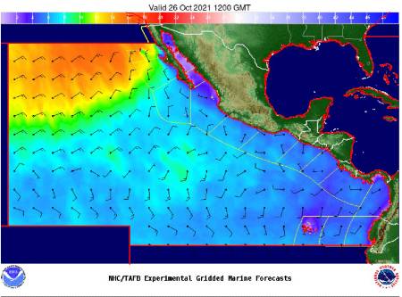
The wind barbs represent wind speed (one barb = 10 knots) and direction. Significant
wave height is represented by the colored shading in feet.
Graphics depicting the gridded winds, seas, and hazards are available through NHC/TAFB’s Marine Graphical Composite Forecast Map at:
https://www.nhc.noaa.gov/marine/forecast/enhanced_epacfull.php .
The gridded forecast files are online via https and ftp at:
ftp://tgftp.nws.noaa.gov/SL.us008001/ST.opnl/DF.gr2/DC.ndfd/AR.oceanic/VP. 001-003/
https://tgftp.nws.noaa.gov/SL.us008001/ST.opnl/DF.gr2/DC.ndfd/AR.oceanic/V P.001-003/
ftp://tgftp.nws.noaa.gov/SL.us008001/ST.opnl/DF.gr2/DC.ndfd/AR.oceanic/VP. 004-007/
https://tgftp.nws.noaa.gov/SL.us008001/ST.opnl/DF.gr2/DC.ndfd/AR.oceanic/V P.004-007/
The gridded forecast graphics can be found at:
- https://digital.weather.gov/
- https://digital.mdl.nws.noaa.gov
- https://ocean.weather.gov
- https://weather.gov/hfo
For further information Contact: NHC Public Affairs: nhc.public.affairs@noaa.gov
…………………………………………………………………………………………………………………………………………
Related Links
NOAA – Pacific Grids Announcement
…………………………………………………………………………………………………………………………………………
Noonsite has not independently verified this information.
Related to following destinations: Alaska, American Samoa, Cook Islands, Easter Island, Federated States of Micronesia, Fiji, French Polynesia, Galapagos, Global, Guam, Hawaii, Kiribati, Marshall Islands, Mexico, New Caledonia, New Zealand, Niue, Norfolk Island, Northern Marianas, Palau (Belau), Pitcairn Island, Samoa, Solomon Islands, Tonga, USA, Vanuatu, Wallis and Futuna, West Coast (Mexico), West Coast (USA), Western Samoa
Related to the following Cruising Resources: Circumnavigation, Circumnavigation, Pacific Crossing, Routing, Weather, Weather Websites
Comments