Current Hurricane and Typhoon Updates

September tends to bring increased storm activity in both the Atlantic and Pacific basins. Right now there are 4 named storms in the Atlantic and a super typhoon in the western Pacific about to threaten the northern Philippines.
Published 7 years ago, updated 6 years ago
Atlantic
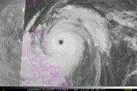
- Mangkhut: Image from https://www.ssd.noaa.gov Florence (near the North Carolina coast), on Tropical Storm Helene (located over the eastern Atlantic Ocean), on Tropical Storm Isaac (located in the eastern Caribbean Sea) and on Tropical Storm Joyce (located about 1000 miles WSW of the Azores).
The US National Hurricane Center is today issuing advisories on Hurricane
With sustained winds of 90 mph, Florence has been downgraded to a category 1 storm and is very slow moving, with storm surge (10-15 feet) and heavy rainfall potentially the biggest problems. It is expected to move onshore by Friday morning. Officials declared a state of emergency in Georgia, South Carolina, North Carolina, Virginia and Maryland in preparation for significant rainfall, flooding storm surge, and damaging winds.
The US National Hurricane Center said that storm Helene is packing winds of 140km/h, but it is expected to weaken from a tropical storm as it moves north from the Azores towards Ireland and the UK, bringing wet and windy weather.
Weakening Tropical Storm Isaac passed over the Leeward Islands Thursday bringing gusty winds and heavy rain with winds of 70km/h. It is now moving off to the west and is expected to weaken into a tropical depression.
Joyce, previously a sub-tropical storm, transitioned to a tropical storm on Thursday. With maximum sustained winds of 65 km/h, little change in strength is expected during the next couple of days and Joyce is forecast to gradually turn toward the northeast on Friday.
Pacific
The BBC reports that Super Typhoon Mangkhut (known locally as Ompong) has gathered strength as it barrels towards the Philippines. The storm has already pummelled the Northern Mariana Islands and Guam and with a diameter of 900km, will be powerful enough to remain a “considerable threat” even if it slows down before making landfall.
Last-minute preparations are underway before it makes landfall on the northern tip of the main island of Luzon by Saturday. Authorities say they expect storm surges of up to 7m (23 feet) and are warning that heavy rains could trigger landslides and flash floods.
Accuweather report that as of early Friday, EDT, the eye of Mangkhut is located about 375 miles northeast of Manila, Philippines, moving WNW at 14 mph, has maximum sustained winds of 125-130 mph and gusts to 180 mph.
Related Content
USA: Strengthening Hurricane Florence to pose a serious threat to US East Coast later this week
Related to following destinations: Luzon (Northern Region), Philippines, Subic Bay, USA
Related to the following Cruising Resources: Atlantic Crossing, Caribbean Sea, Hurricanes and Tropical Cyclones, Pacific Ocean West, Routing, Weather
Comments