Safety Board Investigated Collision and Fire as Possible Causes of the Tragedy
According to news reports at the time of the yacht’s disappearance, officials believed the two bodies were that of 70-year-old man and a 60-year-old woman from British Columbia, Canada. They had been reported missing one week after leaving Halifax Harbour on board their sailboat Theros bound for the Azores. The couple had a YouTube Channel, promoting their eco-friendly sailboat, powered with auxiliary electric propulsion and solar panels.
Their bodies were found in a dinghy on July 10 on Sable Island which is about 95 nautical miles from the closest point on Nova Scotia.
An investigation by the Transportation Safety Board of Canada (TSB) looked closely at the possibility of a collision at sea as the cause but said evidence of a fire was more persuasive:
The investigation concluded: “The data collected is consistent with an occurrence involving a fire on board the sailing vessel.” The following is the report from Marine Transportation Safety Investigation M24A0262, issued on February 12:
Abandonment of Pleasure Craft
Southwest of Sable Island, Nova Scotia 13 June 2024
On 10 June 2024, the sailing vessel Theros departed Halifax Harbour, Nova Scotia, with two people on board for a two-to-three-week voyage to the Azores, Portugal. The vessel was fitted with a Class B automatic identification system (AIS) that was automatically transmitting the vessel’s position to nearby vessels and shore receivers, in addition to AIS satellites. The vessel also had a commercially available satellite communication device that was automatically transmitting the vessel’s position to a website, which could also be used by the crew to send and receive text messages.
On 18 June, the Joint Rescue Coordination Centre (JRCC) in Halifax received a phone call from a concerned individual indicating that the vessel’s position had not been updated recently on the website for the satellite communication device. The last position update was at 1636 Atlantic Daylight Time (ADT) on 13 June, when the sailing vessel was 34 nautical miles southwest of Sable Island, Nova Scotia. The individual also advised the JRCC that the vessel had an emergency position-indicating radio beacon (EPIRB).
The JRCC checked the EPIRB registry and discovered that the vessel’s EPIRB was unregistered and that there was no recent EPIRB activity in the area where the vessel had been transiting. JRCC then checked for the Theros’s AIS signal and noted that the AIS had stopped transmitting a signal as of 1221 ADT on 13 June. The website for the satellite communication device showed the Theros on a consistent course between 1221 and 1636, it showed the Theros on a consistent course of 105° true at speeds of between 3.25 and 4.9 knots. The JRCC used various means to try contacting the Theros directly, but did not receive a response. The JRCC then communicated the situation to other relevant authorities and made ongoing broadcasts to vessels in the area of the Theros’s last known position requesting to be informed of any sightings of the vessel.
Without a distress signal from the Theros and without it being overdue at its destination, there was no way to determine its status. Given that the JRCC had not received any alerts from unregistered EPIRBs that could be linked to the Theros, and the Theros had no formal sailing plan with defined expectations for communication from the crew, the absence of communication was not considered a concern.
By 02 July, approximately three weeks later, the Theros had not arrived in the Azores as planned and was therefore considered overdue. The JRCC sent a Canadian Armed Forces Hercules aircraft to the Azores and back to do a communications and radar search. The JRCC also deployed an aircraft to search the area around the Theros’s last known position. Neither of these searches found any sign of the Theros.
On 10 July, two bodies were found in a dinghy washed up on the south side of Sable Island. The bodies were later confirmed to be those of the crew from the Theros, indicating that the crew members had abandoned the vessel. The Theros was not found.
On 11 July, analysis by the JRCC and the Marine Rescue Coordination Centre in Ponta Delgada, Portugal, identified that based on the predicted course and speed of the Theros at its last known position and the path of a commercial tanker in the area around the same time, it was possible that the two vessels collided on 13 June (see Figure 1). The JRCC advised the TSB of this possibility.
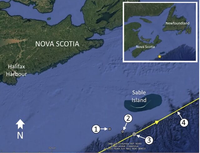
Figure 1. Location of the Theros’s last AIS signal (1), the Theros’s last known position (2), possible collision location with the tanker (3), and the tanker’s AIS track (4), with inset image showing a larger view of the area (Source: Google Earth, with TSB annotations)
TSB involvement
Based on the information received from the JRCC, the TSB collected further data to assess the situation and attempt to determine if a collision had occurred.
TSB assessment
The TSB took the following steps to assess the circumstances:
- Compared the tanker’s track and the Theros’s last known position. At its closest point, the tanker passed just under 10 nautical miles away from the sailing vessel’s last known position.
- Collected data from the commercial tanker, including bridge recordings, AIS data, and radar data. None of the data indicated that the Theros was in the vicinity while the tanker passed south of Sable Island.
- Requested that the JRCC perform drift modelling using the location where the dinghy was found to see if it was possible to determine whether the dinghy had originated from the potential collision location. The drift modelling showed that the dinghy likely came from a location south of Sable Island along the vessel’s anticipated route but was inconclusive as to the specific location.
- Collected data regarding the Theros, including information about its propulsion system, emergency equipment, communication equipment, and crew. The data indicated the following:
- The Theros had an inflatable life raft on board with a hydrostatic release.
- The life raft and the EPIRB were stored in the centre of the vessel near the main hatch to the cabin.
- Neither the life raft nor the EPIRB were found.
- The Theros’s crew were experienced sailors.
- The vessel had at least two flotation suits that were typically worn by the crew members when they were outside the cabin.
- One crew member was found wearing a flotation suit that had fire damage. The suit was melted on the left side from top to bottom. The fire damage had occurred while the crew member was wearing the suit; it would not have been possible to don the suit in the damaged condition.
- The flotation suit was the only item found that was damaged by fire.
- The other crew member was not wearing a flotation suit. There was a flotation suit in the dinghy.
- The crew had been planning to stow the dinghy on the vessel’s stern for the duration of the voyage.
- The vessel’s propulsion system had been retrofitted with an electric system that incorporated an electric car battery.
Conclusion
A collision involving a commercial vessel is reportable to the TSB as a transportation occurrence. There was no report of such an occurrence made to the TSB by the tanker when it was operating in the area of the Theros’s last known position.
The TSB has conducted investigative work to determine if there was a definitive connection between the tanker operating south of Sable Island and the disappearance of the sailing vessel on 13 June 2024. The TSB investigation has not identified any link between commercial vessel traffic operating south of Sable Island and the missing sailing vessel. The data collected is consistent with an occurrence involving a fire on board the sailing vessel.
………………………………
Related News:
- Tragic Outcome in Search for Missing Sailors (Noonsite July 2024)
- Two People Found Dead in Lifeboat Washed Ashore Near Nova Scotia’s Sable Island (The Globe and Mail)
- Video – Global News – Tragic End for BC Sailors found dead in a lifeboat off Nova Scotia
- Facebook Sailing and Cruising
………………………………
Noonsite has not independently verified this information.
………………………………
Find out all news, reports, links and comments posted on Noonsite, plus cruising information from around the world, by subscribing to our FREE monthly newsletter. Go to https://www.noonsite.com/newsletter/.
Leave a comment
You must Login or Register to submit comments.