Australia: Queensland Braces for Tropical Cyclone Kirrily

A tropical low that formed in the Coral Sea is expected to strengthen and reach the Queensland coast later this week as a category three severe tropical cyclone.
Published 3 months ago

Australia’s WeatherZone website said the low pressure system will gain strength as it draws energy from the warm surface water of the Coral Sea and will be named Kirrily when it reaches tropical cyclone strength.
Current forecast model guidance has Kirrily reaching the Queensland coast on Thursday 25 January, most likely as a category three severe tropical cyclone – on the Australian scale this can produce maximum mean wind speeds of 118 to 159 km/h and gusts of 165 to 224 km/h.
Australia’s Bureau of Meteorology expect the cyclone to cross the coast between Innisfail and Airlie Beach and a severe impact is likely, particularly if the system crosses near or south of the city of Townsville.
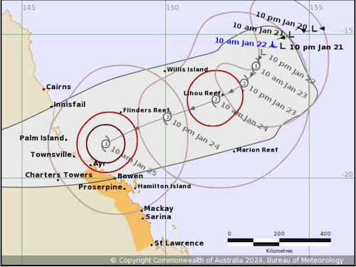
As the system approaches the coast, a Storm Tide is possible between Ayr and St Lawrence with large waves possibly producing minor flooding along the foreshore.
After the cyclone crosses the coast, it is then expected to weaken to a tropical low and move further south, bringing heavy rainfall to inland areas.
………………………………
Related News:
- Queensland Bracing for Severe Tropical Cyclone Impact
- Chaotic 120km/h wind gusts, intense rainfall forecast to lash Queensland
- Potential Cyclone Impact Zone Widens
………………………………
Related Links:
- Australia Government Bureau of Meteorology – Tropical Cyclone Warnings
- WeatherZone.com.au
- Noonsite Weather Resources
………………………………
Find out all news, reports, links and comments posted on Noonsite, plus cruising information from around the world, by subscribing to our FREE monthly newsletter. Go to https://www.noonsite.com/newsletter/.
Related to following destinations: Cairns, Mackay, Port Douglas, Queensland, The Whitsunday Islands, Townsville
Related to the following Cruising Resources: Hurricanes and Tropical Cyclones, Weather
Comments