Sailing to South Africa
Important factors to consider when going down the Mozambique Channel
One is the Agulhas Current running north to south and the other is the two prevailing wind directions.
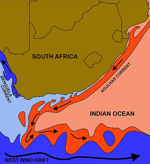
The Agulhas Current
The rate of current is around 1 – 2kn on average up north, and around 2 – 5kn down south – assisting in your passage south.
The prevailing NE wind
The prevailing NW wind runs with the current and in general ranges from around 12 to 25kn on average. The wind strength does however occasionally top 40kn, making conditions very uncomfortable.
The counter-prevailing SW wind
The counter prevailing wind being a SW wind driven by polar fronts peeling off from the lower latitudes – is the worrisome one. These winds usually take the form of a strong to very strong pre-frontal ‘buster’ that averages around 35kn at first and then eases up to an average of 15 to 20kn for a day or two. The more intense fronts can deliver winds up to and over 50kn and even stronger.
The SW wind creates a wind over current situation that creates steep waves at close intervals, making it more dangerous.

Durban to East London
As you progress south of Durban the current accelerates up to and over 5kn and even quicker at times. Not only does the current accelerate, but it also moves a lot closer to shore than up north.
SW busters in this area regularly reach the 40kn range and the sea state easily reaches 6 to 8m+, making it a very dangerous section of coastline.
Short weather windows
The weather window period between fronts is usually around 3 to 4 days in times when the systems are stable.
In periods of instability it goes down to a 40-to-48-hour cycle. This is rather important as you have to bank on a minimum of a 48 hour window to do the 250nm passage from Durban to East London. This 48 hour allowance would include a safety window of 8 to 10 hours in case of a sudden change (happens reasonably often) in the weather forecast model(s).
No shelter
Keep in mind that between Durban and East London there are no safe harbours or hiding holes to shelter from the SW fronts.
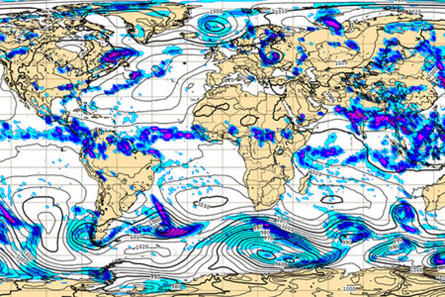
Climate Models for the SA Coast
A note on the climate models for the southern African coastline.
The ECMWF model is the most accurate in general.
South Africa has 42 coastal reporting stations, but a large number of these stations are out of action or only transmit data intermittently to NOAA. The result of this is that the weather models for the region are ‘smoothed out’ to allow for the missing information – which means it is an approximation and can therefore contain errors. It does for example not have information on small isolated weather anomalies that occur often on the Wild Coast and can affect your passage south.
Sail with one eye on the barometer at all times.
How to Identify the Agulhas Current
- The smell of the ocean changes quickly.
- The colour changes to a deep dark blue – almost deep purple.
- The temperature is approximately 2 to 3 degrees warmer than the water out of current. Check you inlet water temperature or an “old school” thermometer will do the trick.
- There is often a line of clouds running parallel to the coastline (more prevalent in winter) emanating from the higher rate of evaporation and condensation over the current.
Remember:
Timing and patience is everything in selecting the best possible window for your passage. Enjoy your passage and relax at your stops. Explore and see the sights. Your window will present itself in good time.
Remember that if you get it wrong the penalty can be rather severe – as this coastline is a known “boat breaker”.
Read: Extensive Search Underway for Missing Sailing Vessel Katouska Off Eastern Cape Coast (17 October, 2025)
Switch your AIS on when you are travelling along the South African coast! It is an imperative for your own safety.
Guidance Article by Vince Nel
OSASA Director (Offshore Sailing Association of South Africa)
OCC Port Officer Representative for Durban (Ocean Cruising Club)
RNYC Member of the General Committee (Royal Natal Yacht Club)
……………………..
Related Articles on Noonsite:
Madagascar and Mozambique Channel (by Des Cason)
The Challenge of Passage Planning in the SW Indian Ocean (by SY Sofia)
……………………..
© 2025 Noonsite. This content was edited by Noonsite. Do not reproduce without permission. All rights reserved.
The opinions expressed in this article are the author’s own and do not reflect the view of Noonsite.com or World Cruising Club.
If you have found this information useful, become a paid member to enjoy unlimited use of Noonsite plus many other perks. Your membership fees really help our small, dedicated team keep country information up-to-date in support of cruisers worldwide. Find out more about Noonsite Membership levels and benefits here.
Subscribe to our FREE monthly newsletter.
Leave a comment
You must Login or Register to submit comments.