UK & Med: Imray Digital Charts now available on Raymarine chartplotters
Designed and published in England for nearly 200 years, Imray charts feature popular, carefully edited and award-winning cartography. Having worked with Johnson Outdoors Canada Inc. (formerly Northport Systems Inc.) Imray has now made these digital versions available.
Published 8 years ago, updated 6 years ago
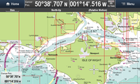 Updated quarterly, Imray Digital Charts use raster images. This means that they correspond exactly to the equivalent Imray paper charts. Each digital chart pack is geo-referenced and quilted to zoom and pan smoothly among hundreds of the equivalent Imray paper charts for that area. In addition, Imray’s acclaimed large-scale harbour plans, also found on the paper charts, usefully provide all necessary information in one place.
Designed for small and leisure craft
Based on the latest licensed Hydrographic Official surveys alongside information supplied by experts, local sources and experienced mariners such as Rod Heikell in the Mediterranean and Don Street Jr. in the Caribbean, Imray charts are meticulously edited by skilled cartographers.
Carefully plotted and edited scales enable navigators to plot courses between destinations with the minimum number of chart sheets. Reflecting Imray’s long experience and knowledge of the navigator’s requirements, they offer more intelligent schemes than other series where official data has been reformatted and forced into the page.
Thorough editing ensures that only the information useful to small craft navigation is presented, avoiding clutter. Shoreside detail is included, but only where useful for navigators.
Use of IMO approved signs and symbols. Imray digital charts may be used alongside official charts.
Familiar colours
For current users of Imray charts, the colour scheme will be familiar. For new users, Imray’s chart colours are logical; blue for sea, green for land, drying depths in yellow and white.
Approved for use on small craft by the UK’s Maritime and Coastguard Agency.
Imray charts have been awarded official MCA (Maritime and Coastguard Agency) recognition for use on code vessels and fishing vessels under 24m in length.
Imray chart packs now available for Raymarine chartplotters
ID30 West Coast of Britain & Ireland
ID40 Atlantic France & Iberia, ID70 Eastern Mediterranean & Aegean Seas and ID100 Eastern Caribbean to follow soon.
Imray Digital Charts for Raymarine are compatible with Lighthouse II Raymarine Plotters
Available via the Raymarine Lighthouse Chart Store (choose Brand>Imray).
Related to the following Cruising Resources: Books, Charts, Cruising Information, Equipment
Comments