Northeastern Pacific Ocean: New Satellite Improves Weather Forecasting
NOAA’s GOES-17 satellite improves our ability to forecast the weather over Alaska, Hawaii and the northeastern Pacific Ocean.
Published 5 years ago
As reported by https://www.nesdis.noaa.gov
NOAA’s GOES-17 satellite has reached an exciting new milestone: On November
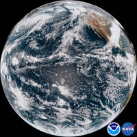
13, 2018, the satellite began transmitting its first high-definition images of Alaska, Hawaii, and the Pacific Ocean. The new imagery became available shortly after GOES-17 finished moving to its new orbital position at 137.2 degrees west longitude, where it will become NOAA’s operational GOES-West satellite on December 10, 2018.
With GOES-17’s coverage area now centered over the Pacific Ocean, we now have high-resolution geostationary satellite coverage of Alaska, Hawaii and much of the Pacific Ocean for the very first time.
Launched March 1, 2018, from NASA’s Kennedy Space Center, GOES-17 is the second in a series of NOAA’s next-generation geostationary weather satellites. Like GOES-16, its sister satellite operating as GOES East, GOES-17 is designed to provide advanced imagery and atmospheric measurements of Earth from 22,300 miles above the equator.
The Advanced Baseline Imager (ABI) on-board GOES-17 is identical to the instrument on GOES-16. The GOES-17 ABI will offer the same high-resolution visible and infrared imagery in GeoColor and 16 different channels, allowing us to track and monitor cloud formation, atmospheric motion, convection, land surface temperatures, fire and smoke, volcanic ash, sea ice, and more.
GOES-17 will significantly enhance our ability to forecast the weather in the western United States, especially in Alaska and Hawaii. With its expanded satellite coverage at high latitudes, GOES-17 will provide a significantly clearer view of the state of Alaska, where it will improve our ability to track environmental conditions, such as sea ice, volcanic ash, snow cover and wildfires. GOES-17 will also provide more and better data over the northeastern Pacific Ocean, where many weather systems that affect the continental U.S. begin.
Related to the following Cruising Resources: Pacific Ocean East, Routing
Comments