South Indian Ocean: Navigational Warning for Mozambique Channel
Warning for vessels travelling between Madagascar and South Africa to be on the lookout for a slow moving survey vessel which is unable to manoeuvre.
Published 11 years ago, updated 5 years ago
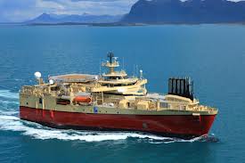 A seismic survey vessel will be operating in the Mozambique Channel for several months. The vessel travels at 2.5 knots towing a cable 8000 meters long and cannot deviate from course and speed for any reason whatsoever. All vessels are required to give wide clearance.
Current boundary coordinates are (as at 5th October 2013) :
17 deg 18min South 42 deg 29 min E
17 deg 22 min South 42deg 14 min E
16 deg 58 min South 42 deg 08 min E
16 deg 55 min South 42 deg 23 min E
These coordinates will change every few weeks.
It is on the route for vessels between NW Madagascar and Richard’s Bay.
Our thanks to Roger Morgan of Yacht “Wapiti” for this information.
Related to following destinations: Madagascar, Mozambique, South Africa
Related to the following Cruising Resources: Indian Ocean, Routing
Comments