
Bora Bora: New Anchoring Restrictions for all Yachts – 2019

New legislation has been introduced to restrict anchoring inside Bora Bora Island in order to protect the environment and ensure the peaceful coexistence of all users of the waterways.
Published 5 years ago
 Translated from this French Voiliers Association report with assistance from Chuck Houlihan on SV Jacaranda, Price and Gail (Benny) Powell
Restrictions Introduced for Internal Waters of Bora Bora
November 2018: Government officials in French Polynesia have met to finalize the new restrictions being put in place for regulating the mooring of vessels in the internal waters of Bora Bora Island.
Restrictions have been put in place in order to protect the environment and the safe navigation of boat traffic in the inland waters of Bora Bora Island. The new restrictions will also assist in maintaining the harmonious coexistence of users in the public maritime domain.
The internal waters of Bora Bora have been divided into zones dedicated to authorized anchorage with specific restrictions applying to each.
Vessels 10+ meters in length or anchorage of 24 hours or more are strictly forbidden outside areas dedicated to authorized anchorage.
The anchorage of any vessel, for any length of time, is strictly forbidden in the navigation channels.
Exemptions may be provided to ships engaged in public service or in a rescue operation.
Delineation of Zones
Zone A – Anchorage areas for vessels with a length greater than or equal to 20 meters.
Only anchorage of vessels with a length greater than or equal to 20 meters is authorized on the following points:
Denomination, Longitude, Latitude, Radiation radius
Ahuna 1 151 ° 46,121’0 16 ° 29.246’S 150 meters
Faanui 1 151 ° 45.449’0 16 ° 28.838’S 150 meters
Hitiaa 1 151 ° 44.4590 16 ° 27.978’S 150 meters
Hitiaa 2 151 ° 44,051’0 16 ° 28.223’S 150 meters
Hitiaa 3 151 ° 43.719’0 16 ° 28,413’S 150 meters
Toopua 1 151 ° 46.664’0 16 ° 31,361’S 130 meters
Vaitape 1 151 ° 45,760’0 16 ° 30.838’5 150 meters
Vaitape 2 151 ° 45.670’0 16 ° 31,07515 150 meters
Zone B – Zone dedicated to the anchorage of vessels with a length of less than 20 meters.
Only the anchorage of vessels with a length of less than 20 meters is allowed on the following points.
The perimeter of each zone is determined by the reference points indicated by zone.
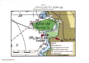
1. The delimitation of the area of Nunue Bay is defined by the following points:
 Denomination, Longitude, Latitude
BN-1 151 ° 45.180’0 16 ° 30.028’S
BN-2 151 ° 45.129’0 16 ° 36.052’S
BN-3 151 ° 45,159’0 16 ° 30.109’5
BN-4 151 ° 45.254’0 16 ° 30,119’S
BN-5 151 ° 45300’0 16 ° 30.097’5
BN-6 151 ° 45.307’0 16 ° 30.065’S
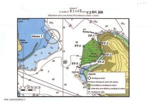
2. The delimitation of the zone of Fare Piti is defined by the following points:
 Longitude, Latitude
FP-1 151 ° 45.656’0 16 ° 29,270’S
FP-2 151 ° 45.575’0 16 °29,322’S
FP-3 151 °45.544’0 16 °29,444’S
FP-4 151 °45.629’0 16 °29,522’S
FP-5 51 °45.796’0 16 °29,571’S
FP-6 151 ° 45.761’0 16 ° 29,354’S
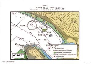
3. The delimitation of the Faanui zone is defined by the following points:
 Denomination, Longitude, Latitude
FA-1 151 ° 45.165’0 16 °28,899’S
FA-2 151 °45.190’0 16 °28.948’S
FA-3 151 °45238’0 16 °28,949’S
FA-4 151 °45,268’0 16 °28,898’S
In this area, the anchorage of vessels is strictly limited to five (5) vessels.
The duration of stay of vessels in this area may not exceed thirty-six (36) hours.
4. The delimitation of the Hitiaa area is defined by the following points:
 Denomination, Longitude, Latitude
11I-1 151 ° 44.2490 16 °28,266’S
HI-2 151 °44,276’0 36 °28,316’S
III-3 151 °44.324’0 16 °28,316’S
HI-4 151 °44.355’0 16 °28,266’S
In this area, the anchorage of vessels is strictly limited to five (5) vessels.
The duration of stay of vessels in this area may not exceed thirty-six (36) hours.
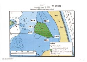
5. The delimitation of the Motu Fareone area is defined by the following points:
 Denomination, Longitude, Latitude
MF-1 151 °42.319’0 16 °31..772’S
MF-2 151 °42.130’0 16 °32,091’S
MF-3 151 °42267’0 16 °32111’S
MF-4 151 °42.595’0 16 °31,983’S
MF-5 151 °42.585’0 16 °31,846’S
MF-6 151 °42.518’0 16 °31,726’S
6. The delimitation of the area south of Povai Bay is defined by the following points:
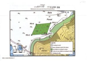 Denomination, Longitude, Latitude
P0.1 151 ° 44.442’0 16 °31410’S
P0.2 151 °44,520’0 16 ° 31.618’S
P0-3 151 ° 44.82316 ° 31.645’S
P0’-4 151 ° 44,728’0 16 ° 31.437S
7. The delimitation of the zone west of the Toopua Motu is defined by the following points:
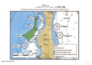 Denomination, Longitude, Latitude
T0-1 151 ° 46313’0 16 ° 30,623’S
TO.2 151 ° 46.343’0 16 ° 30,942’S
T0-3 151 °46.4080 16 °31,090’S
T0-4 151 °46.5620 16 °31,236’S
To.5 151 °46.707’0 16 °31,088’S
T0-6 151 °46.4010 16 °30,870’S
To.7 151 °46.372’0 16 °30,619’S
The delineation of the authorized anchorage zones is available from the Polynesian Maritime Affairs Department (DPAM) and on the website www.maritime.gov.pf and www.service-public.pf/dpam/.
Access and Rules of Navigation Inside Areas Dedicated to Anchorage
Access to dedicated areas is permitted for vessels in a state of navigation, as well as for those in danger of damage.
Access to dedicated areas by vessels in danger or in damaged condition is only allowed for a limited stay, justified by the circumstances.
Access and movement within the areas designated for authorized anchorage shall be carried out in accordance with the rules of navigation, in particular, those laid down in the International Regulations for Preventing Collisions at Sea.
Within the limits of these dedicated zones, the maximum speed of vessels is fixed at 3 knots.
Except in the case of emergency, vessels are only allowed to move within the dedicated zone to access or leave an anchorage point.
Declaration of Entry and Departure
Any ship intending to anchor in one of the authorized anchorage areas shall, upon arrival, notify the authorized manager and make an entry declaration by any appropriate means (telephone, fax, e-mail, VHF) to transmit the following:
1. A photocopy of the ship’s documents (registration certificate, flag identification and vessel owner)
2. A photocopy of the owner’s passport or, if applicable, the user of the ship. Accurate contact details of the owner, or if applicable, the vessel’s user (phone numbers, email).
3. The expected date of departure from the mooring area. In case of modification of this date, a declaration is made without delay to the authorized manager of the authorized zone;
The authorized manager must also be notified of departure.
Note: Noonsite is in contact with La Direction Polynésienne des Affaires Maritimes (DPAM), in an attempt to determine exactly how skippers contact the Authorized Manager and the contact details.
Use of Zones Dedicated to Authorized Anchorage
The master of every ship is responsible for ensuring that the ship, at all times and in all circumstances, does not cause damage to other vessels or interfere with the use of the anchorage area authorized by other users.
In case of necessity, all precautions, maneuvers or displacements, changes of location prescribed by the authorized manager, must be respected or executed, in particular when they are considered necessary to facilitate the movements of the other ships or to ensure the safety of the navigation and traffic in the inland waters of Bora Bora Island.
Within the limits of the zones dedicated to the authorized anchorage, the practice of any nautical, aquatic, or underwater activity is strictly forbidden for reasons of safety of the navigation.
Hygiene and pollution
Vessels at anchorages in one of the areas designated for authorized anchorage may not discharge into the water their garbage or refuse of any kind, nor any water polluted or loaded with hydrocarbons, oils or toxic products. Any discharge to the sea is strictly forbidden.
All waste must be deposited in land-based facilities provided for this purpose. The discharge of wastewater is subject to special regulations.
It is forbidden to perform on the moored vessels in the authorized anchorage areas any repair, product applications, or paints.
Removal of Shipwrecks and Abandoned Vessels
All vessels staying in areas designated for authorized anchorage must be kept in a good state of maintenance, buoyancy and safety.
If the authorized manager ascertains the presence of a wreck or a ship is in a state of manifest abandonment or lack of maintenance, and presents, in whole or in part, a dangerous character for navigation, fishing or the environment, the access to a port or the stay in a port, that it poses a potential to cause damage to the ships, to the surrounding works or to the environment, the authority is responsible for giving the owner notice to take any measure necessary to eliminate the dangerous nature of the vessel.
In the event of inaction by the owner of the vessel within the prescribed period, the competent authority shall proceed ex officio with the operations necessary for the costs and risks of the owner to put an end to the risk of danger or injury to the public maritime domain. For the removal of the wreck, the owner of the ship shall comply with the requirements issued by the competent authority.
Related content
Related to following destinations: Bora Bora, French Polynesia, Society Islands
Related to the following Cruising Resources: Anchorages, Cruising Information
Related to the following Services, Goods and Amenities: Docking


Waypoint BN-2 should read 16 30.052S