Cook Islands, Aitutaki : Updates from Cruisers
Two cruiser reports that provide information on the entrance to the lagoon and tips while visiting.
Published 7 years ago, updated 5 years ago
 Aitutaki: The good, the bad and the ugly – posted September 2017
Other cruisers will be pleased to know this before visiting Aitutaki.
The Good
Meeting the amazing Nolan family. Renting their scooters for island tours and hiring their boat Wahoo. They became friends in a few days rather than just business.
Enjoying the dining and entertainment at the Thursday Island night.
The Bad
Absolute max draft 1.7 at high tide, be prepared to bump. Charts 1.5 at LW is wishful thinking.
A place for approx 5 yachts med-mooring style, side onto prevailing wind in the harbor. Can be done, but involves lots of messing about.
Place for max 3 other small boats in the channel in front of the harbor.
The lagoon suffered a bleaching event early in 2017. Lagoon corals are mostly dead.
The Ugly
One official is enforcing no access to the lagoon unless with a licensed operator. This includes no dinghy, SUPs, kitesurfers, divers, fishing basically nothing allowed by yourself. Water taxi rides to the kite spots are NZ $35 per head/day, no group or multiple rates from the site operators. We found this extortion, especially when one is paying 250 for a kitesurf lesson or renting gear already.
We originally chose to pick one Cook island and spend a month there, only to find the restrictive nature of Aitutaki and the prohibitive costs for a family wanting to kite, dive, and paddle for a month. Unless you have very deep pockets or are not interested in the lagoon, after your land tour, you will be confined to your boat in a muddy harbor.
This is on top of already expensive official fees that are well documented on Noonsite. There are no printed rules, no notice boards or web site information to warn upfront, and is just enforced by a chap yelling and intimidating yachties and their families from the wharf – which is a bit late.
We took this unfairness up with the Mayor in person, Tourism office and customers office, and nobody would confirm, deny or provide rules, but rather took the lazy way out of the discussion by saying that it is Local Council rules from their forefathers. We waited a few days while the Mayor considered our request for leniency or could provide written rules. This was however not granted and we were advised: “you don’t want to break the Law”.
It remains a mystery to us and other cruisers how come the mystery rules only started getting enforced mid-August 2017 since they were made by council forefathers. Ourselves along with 4 other buddy boats left on the next weather window cutting the time short in Aitutaki by 3 weeks and moving onto countries that are interested in Tourism.
Such a disappointing end to something that we thought would be a highlight of the Pacific. Hopefully, Aitutaki can put their heads together sometime soon but suspect this could take a long time.
Barry Boswell
Yacht Jadean
Useful Directions for the Pass – posted August 2013
Detailed directions for entering the anchorage at Aitutaki in the southern Cook Islands and a warning to not rely on electronic navigation.
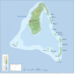
If arriving from the south you will need to be slightly north of the pass before you see it clearly as the pass runs in a southwesterly direction. Under no circumstances rely on electronic charts, they are well out as a badly damaged steel boat here can confirm.
The pass is narrow but do-able especially if you have someone on the pulpit with polarized sunglasses. At the time I arrived the pass had been deepened slightly to help ferry boats from a small cruise liner. A boat drawing 6 feet failed to get in on the top of High Water Springs and had to be towed off. A draught of 1.7 meters at high water is the absolute maximum. Do NOT rely on your electronic charts for the times of high and low water
When you identify the pass you will see a long (not quite straight) line of white stakes. All the stakes are white. Leave them all to port EXCEPT the last two which, amazingly you leave to starboard – if you leave them to port you will be well aground. This brings you to the inner anchorage where you will anchor fore and aft with fenders on each side. It is like sardines but has good shelter.
If the inner anchorage is full there is another anchorage a couple of hundred yards towards the reef which will hold at least three boats. Before you reach the starboard hand stakes there is a clear but narrow channel to starboard where you can again anchor fore and aft. You will need to anchor well as the wind comes from every direction so pick a spot where you will be clear of reefs, sandbanks, and bombers. You will definitely need somebody high in the bow to get in here.
Conventional wisdom says do not attempt to anchor outside the reef – it is a graveyard for anchors
Good luck; it is a lovely island and worth the trouble.
Anthony Swanston
SV Wild Fox
Related content
Related to following destinations: Aitutaki, Cook Islands, Southern Cook Islands
Related to the following Cruising Resources: Cruising Information, Routing


Update 30.5.2023
The channel has been dredged to 2.2m (that was the lowest water level we measured during entry). However if your draft is more than 1.7m you will find it very difficult to find a spot without ground contact. Anchoring in the harbour and using stern line to the pier – we did it and were forced to leave by bio security people (we came from French Poly and they were afraid that we import insects when our boat has land contact). Anchoring in the harbour area: we did it and had several ground contacts. Several spots have less than 1.8m in spite of the port authority confirming to us, that the area is dredged to 3+ meters.
Sorry to say: in the current condition Aitutaki is a no go place for boats with more than 1.7m draft.